
Ostrzeszów
| Ostrzeszów | |||
|---|---|---|---|

|
|
||
| Basic data | |||
| State : | Poland | ||
| Voivodeship : | Greater Poland | ||
| Powiat : | Ostrzeszów | ||
| Area : | 12.00 km² | ||
| Geographic location : | 51 ° 26 ' N , 17 ° 56' E | ||
| Height : | 150 m npm | ||
| Residents : | 14,137 (Jun. 30, 2019) |
||
| Postal code : | 63-500 | ||
| Telephone code : | (+48) 62 | ||
| License plate : | POT | ||
| Economy and Transport | |||
| Rail route : | Kreuzburg – Poznan | ||
| Next international airport : | Poses | ||
| Gmina | |||
| Gminatype: | Urban and rural municipality | ||
| Surface: | 187.00 km² | ||
| Residents: | 23,918 (Jun. 30, 2019) |
||
| Population density : | 128 inhabitants / km² | ||
| Community number ( GUS ): | 3018073 | ||
| Administration (as of 2014) | |||
| Mayor : | Mariusz Witek | ||
| Address: | ul.Zamkowa 31 63-500 Ostrzeszów |
||
| Website : | www.ostrzeszow.pl | ||

Ostrzeszów [ ɔ'stʃɛʃuf ] ( German Schildberg ; 1943–1945 Schildberg (Wartheland) ) is a city in western Poland and belongs to the Greater Poland Voivodeship . It is the district town of Powiat Ostrzeszowski and the seat of the town and country municipality of the same name . Ostrzeszów is located about 130 km southeast of Poznan and about 100 km northeast of Wroclaw in the middle of the Wzgórza Ostrzeszowskie, a ridge on the border between Greater Poland and Lower Silesia .
history

The beginnings of the settlement from which Ostrzeszów emerged go back to the times before the Christianization of Poland under the Piasts . Ostrzeszów was promoted to town between 1261 and 1283. In the 14th century there was a first boom under King Casimir the Great , which began as a result of the expansion of the city into a border fortress with city walls and a castle. His successor Ludwig I gave his loyal vassal Wladislaus II of Opole the whole of Wielun, to which Ostrzeszów also belonged at the time. Since then, the city has been in closer contact with other cities under the rule of the Duke of Opole. In 1386 he confirmed a protective alliance of 21, mostly Silesian cities, including “Schiltberg”, concluded at his instigation, to ensure peace. The location of the city on the important trade route from Breslau via Kalisch to Thorn was mentioned by King Sigismund I the Old . The Polish rulers tried to promote the development of the city through a salt privilege, the establishment of a Starostei and a Powiat.
At the beginning of the second Swedish-Polish war, the city was besieged and conquered by Swedish troops in 1656 , who then burned down the fortress in particular. A reconstruction of the fortifications, which was considered by the Polish Reichstag, was not implemented. The city lost its importance and, when it passed to Prussia as a result of the second partition of Poland in 1793, only had about 1000 inhabitants; the German place name Schildberg hardly appeared at that time.
From 1807 to 1815 Ostrzeszów was part of the Duchy of Warsaw and a district town in the Kalisch department, in 1810 there are 1,300 inhabitants. After the Congress of Vienna, the city again belonged to Prussia and was confirmed as a district town in 1818. From 1832 onwards, the German term Schildberg , which was rarely used in the past, was used almost exclusively for the town and district of Ostrzeszow.
During the Prussian era, the city's population increased slowly at first, but then sharply: 1525 inhabitants are given for 1816, 42 years later (1858) there were first 2289, 1871 then 2576 and 1910 even 5471 inhabitants.
After the First World War and the return to Poland in 1918, economic and social life began to revive. In 1925, in the presence of General Józef Haller in Ostrzeszów, the monument commemorating the Poznan Uprising (1918-1919) was unveiled.
The occupation by the German Reich during the Second World War from 1939 to 1945 brought severe reprisals to the population. The Wehrmacht maintained a large POW camp in Ostrzeszów, in which up to 125,000 Polish and Allied POWs were interned. The part of the camp called Heilag XXI (returnees' camp) was used to keep Norwegian prisoners of war. His remains can be seen in the Norwegian POW Museum in Ostrzeszów .
After the liberation in 1945, war damage was cleared up and the city's population grew steadily over the post-war decades. Due to the Polish territorial reform of 1998, Ostrzeszów has been the district town of the newly established Powiat Ostrzeszowski since January 1, 1999 .
traffic
Ostrzeszów is on the Kluczbork – Poznań railway line ; earlier there was also the Ostrzeszów – Namysłaki railway .
Attractions
In Ostrzeszów, the remains of the old town fortifications from the first half of the 14th century with bastion and city wall, the former Bernardine monastery from the second half of the 17th century and the town parish church, the wooden church of St. Nicholas (18th century) and the Monument to the Wielkopolska Uprising.
In the immediate vicinity, the village of Antonin, 12 km to the north, with an aristocratic residence that is well worth seeing, and the local recreation area of Kobyla Góra with the highest elevation in Greater Poland, 8 km southwest in the Wzgórza Ostrzeszowskie, are worth a visit.
local community
The urban and rural parish ( gmina miejsko-wiejska ) Ostrzeszów consists of the following localities:
| Surname | German name (1815-1918) |
German name (1939-1945) |
|---|---|---|
| Bledzianów | Bledzianow 1908-1918 Blessenau |
Blessenau |
| Jesiona | Jeschune | Those |
| Kochłowy | Kochlow |
1939–1943 Kochel 1943–1945 Kochlau |
| Korpysy | Ottosberg | Ottosberg |
| Kotowskie | Kottowski | Kotowski |
| Kozły | Cäcilienthal | Cecilia Valley |
| Kuźniki | Falcon Grove | Falcon Grove |
| Marydół | Marienthal | Mariental |
| Myje | Kamillenthal | Chamomile Valley |
| Najmów | Naumannshof | Naumannshof |
| Niedźwiedź | Bärwalde | Bärwalde |
| Olszyna | Olszyna | Silgendorf |
| Ostrzeszów | Schildberg | Schildberg |
| Ostrzeszów-Pustkowie | Pustkowie | ? |
| Potaśnia | Maria Alois | Maria Alois |
| Rejmanka | Reymannshof | Reymannshof |
| Rogaszyce | Rogaszyce | Horneck |
| Rojów | Rojow | Royhof |
| Siedlików | Siedlikow | Old hut |
| Szklarka Myślniewska | Szklarka Myslniewska 1908–1918 Luisenthal |
Luisental |
| Szklarka Przygodzicka | Glass village | Glass village |
| Turze | Turze | Tischendorf |
| Zajączki | Zayontschki | Hasenheide |
sons and daughters of the town
- Ismar Elbogen (1874–1943) German-Jewish scholar and rabbi
- Gotthold Rhode (1916–1990), German historian
- Jacek Mencel (* 1966), former soccer player
Twin cities
- Stuhr - Germany
Image gallery
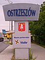
Place-name sign

town hall

monastery
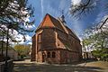
Church of the Assumption of Mary

Christ the King Church

Water tower

map


_ID_653902.jpg)
_ID_653900.jpg)

_ID_653908.jpg)

literature
- Heinrich Wuttke : City book of the country Posen. Codex diplomaticus: General history of the cities in the region of Poznan. Historical news from 149 individual cities . Leipzig 1864, pp. 434-435.
Web links
- Official website of the city - Polish, English, German, French
Individual evidence
- ↑ a b population. Size and Structure by Territorial Division. As of June 30, 2019. Główny Urząd Statystyczny (GUS) (PDF files; 0.99 MiB), accessed December 24, 2019 .
- ↑ Order about a change of place name in Reichsgau Wartheland in the ordinance sheet of the Reich Governor in Warthegau of May 18, 1943 (pdf; 1.9 MB)
- ↑ Tzschoppe and Stenzel: Document collection on the history of the origins of cities ... in Silesia and Upper Lusatia, 1832, p. 243.
- ^ Leonhardi (Earth Description of the Prussian Monarchy, Vol. 5, p. 137) gives 165 chimneys for Schildberg.
- ↑ Timetable on "Kreis Kempen" on territorial.de (in the "Handbook on the Royal Prussian Court and State" the district and the Friedensgericht are still called Ostrzeszow until 1832, and Schildberg from 1834)