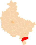
Powiat Ostrzeszowski
| Powiat Ostrzeszowski | |
|---|---|

|

|
| Basic data | |
| State : | Poland |
| Voivodeship : | Greater Poland |
| County town : | Ostrzeszów |
| Area : | 772.37 km 2 |
| Residents : | 55,404 (June 30, 2019) |
| Population density : | 72 inhabitants / km 2 |
| License plate : |
POT
|
| Circle structure | |
| Municipalities : | 0 |
| Urban and rural communities : | 3 |
| Rural communities : | 4th |
| Starostei (Stand:) | |
| Starost : | Lech Janicki |
| Address: | ul.Zamkowa 31 63-500 Ostrzeszów |
| Website : | www.powiatostrzeszowski.pl/po/ |
The powiat Ostrzeszowski is a powiat (district) in the Polish Greater Poland Voivodeship . The powiat has an area of 772.37 km², on which about 55,400 inhabitants live. The population density is 72 inhabitants / km² (2019).
Communities
The powiat comprises seven parishes, including three urban-and-rural parishes and four rural parishes .
Urban-and-rural parishes
- Grabów nad Prosną ( Grabow )
- Mikstat ( Mixstadt )
- Ostrzeszów ( Schildberg )
Rural communities
- Czajków ( Czajkowo )
- Doruchów ( Doruchow )
- Kobyla Góra ( Kobylagora )
- Kraszewice ( Kraszewice )
Web links
Commons : Powiat Ostrzeszowski - collection of images, videos and audio files
Footnotes
- ↑ population. Size and Structure by Territorial Division. As of June 30, 2019. Główny Urząd Statystyczny (GUS) (PDF files; 0.99 MiB), accessed December 24, 2019 .
