
Droga ekspresowa S2
| Droga ekspresowa S2 in Poland | |||||||||||||||||||||||||||||||||||||||||||||||||||||||||||||||||||||||||||||||
| Południowa Obwodnica Warszawy | |||||||||||||||||||||||||||||||||||||||||||||||||||||||||||||||||||||||||||||||

|
|||||||||||||||||||||||||||||||||||||||||||||||||||||||||||||||||||||||||||||||
| |
|||||||||||||||||||||||||||||||||||||||||||||||||||||||||||||||||||||||||||||||
| map | |||||||||||||||||||||||||||||||||||||||||||||||||||||||||||||||||||||||||||||||
 |
|||||||||||||||||||||||||||||||||||||||||||||||||||||||||||||||||||||||||||||||
| In operation In construction | |||||||||||||||||||||||||||||||||||||||||||||||||||||||||||||||||||||||||||||||
| Basic data | |||||||||||||||||||||||||||||||||||||||||||||||||||||||||||||||||||||||||||||||
| Operator: |
|
||||||||||||||||||||||||||||||||||||||||||||||||||||||||||||||||||||||||||||||
| Start of the street: |
Ożarów Mazowiecki ( 52 ° 12 ′ N , 20 ° 51 ′ E ) |
||||||||||||||||||||||||||||||||||||||||||||||||||||||||||||||||||||||||||||||
| End of street: |
Halinów ( 52 ° 12 ′ N , 21 ° 16 ′ E ) |
||||||||||||||||||||||||||||||||||||||||||||||||||||||||||||||||||||||||||||||
| Overall length: | 35.0 km | ||||||||||||||||||||||||||||||||||||||||||||||||||||||||||||||||||||||||||||||
| of which in operation: | 14.6 km | ||||||||||||||||||||||||||||||||||||||||||||||||||||||||||||||||||||||||||||||
| of which under construction: | 20.4 km | ||||||||||||||||||||||||||||||||||||||||||||||||||||||||||||||||||||||||||||||
| Requirement for use: | Truck route toll | ||||||||||||||||||||||||||||||||||||||||||||||||||||||||||||||||||||||||||||||
| Development condition: | 2 × 3 lanes | ||||||||||||||||||||||||||||||||||||||||||||||||||||||||||||||||||||||||||||||
 |
|||||||||||||||||||||||||||||||||||||||||||||||||||||||||||||||||||||||||||||||
| The S2 at the W.-Opacz junction in the direction of Konotopa | |||||||||||||||||||||||||||||||||||||||||||||||||||||||||||||||||||||||||||||||
|
Course of the road
|
|||||||||||||||||||||||||||||||||||||||||||||||||||||||||||||||||||||||||||||||
The Droga ekspresowa S2 ( pol. For "expressway S2") is partly completed or mostly planned expressway in Poland . It is also known as the Warsaw South Bypass (Południowa Obwodnica Warszawy) . In the future it will connect the A2 motorway between the Konotopa and Warszawa Lubelska motorway junctions . The S2 expressway will be part of Europastraße 30 and should be completed by 2020.
Planning history
A southern bypass around Warsaw was planned as early as the 1970s. However, this was planned as a motorway and should become part of the Autostrada A2. After several protests by the affected population of Warsaw and Ursynów , the government decided in 2004 to implement the southern bypass of Warsaw as an expressway. However, the course of the planned route was not changed.
Completed sections
|
Konotopa - Warszawa Południe
This 10.4 km long section of the S2 leads from node Konotopa to node Warszawa Południe ( "Warsaw-South").
Warszawa Południe - Warszawa Puławska
This 4.2 km long section of the S2 leads from the Warszawa Południe junction ("Warsaw South") to the Warszawa Puławska junction.
Sections under construction
| section | length | Contract signing |
construction time | building-costs | planned completion |
|---|---|---|---|---|---|
| Warszawa Puławska Knot - Warszawa Przyczółkowa Knot | 4.6 km | December 11, 2015 | 2015-2020 | 1.22 billion zloty (306 million euros) |
August 2020 |
| Warszawa Przyczółkowa Knot - Warszawa Wał Miedzeszyński Knot | 6.5 km | December 11, 2015 | 2015-2020 | 758 million zlotys (190 million euros) |
August 2020 |
| Warszawa Wał Miedzeszyński Knot - Warszawa Lubelska Knot | 7.5 km | December 11, 2015 | 2015-2020 | 562 million zlotys (141 million euros) |
August 2020 |
| Warszawa Lubelska node (S2 / A2 / S17) | 1.8 km | July 25, 2017 | 2017-2020 | see below (a) | October 2020 |
| total | 20.4 km | 2.54 billion zlotys (637 million euros) |
|||
Warszawa Puławska - Warszawa Przyczółkowa
This 4.6 km long section runs from the Warszawa Puławska node to the Warszawa Przyczółkowa node. It is carried out along its entire length with two lanes, each containing three lanes.
The main component is the approximately 2,300 m long Ursynów tunnel , which is led through a free corridor between residential buildings in the Warsaw district of the same name . The tunnel passes under the M1 line of the Warsaw Metro . Each carriageway in the tunnel will be 14.5 m wide and contain three lanes and an approximately 3.75 m wide hard shoulder. There are escape routes one meter wide to the left and right of both lanes.
The Ursynów Zachód (“Ursynów-West”) and Ursynów Wschód (“Ursynów-East”) junctions are planned at both ends of the tunnel, although both junctions do not contain all of the connection ramps. At the Ursynów Zachód junction, it is only possible to enter the S2 in a westerly direction and exit from the S2 from the west, while at the Ursynów Wschód junction it is only possible to exit from the S2 from the east and join the S2 in an easterly direction is possible.
Warszawa Przyczółkowa - Warszawa Wał Miedzeszyński
Warszawa Wał Miedzeszyński - Warszawa Lubelska
Warszawa Lubelska
A 1.8 km long section of the S2 is being built as part of the Warszawa Lubelska motorway junction.
photos

Course and knot of the S2

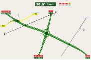
Scheme of the Konotopa knot
Scheme of the Warszawa-Opacz junction, consisting of a motorway junction, a full and a partial junction

Signs for the S2 / S7 / S8 in the direction of the Konotopa junction


Web links
- Construction of the section Warszawa Puławska – Warszawa Lubelska (Polish)
- GDDKiA (Polish)
- Details on the S2 and S79 at siskom.waw.pl
Individual evidence
- ^ S2 Puławska - Lubelska GDDKiA
- ↑ Eugeniusz Buszma: "Drogowiec" No. 8 from 1971 ( Memento from December 18, 2007 in the Internet Archive ) (Polish)
- ↑ Decision of the Regional Council of March 15, 1972 ( Memento of December 18, 2007 in the Internet Archive ) (Polish)
- ↑ Decision of the regional council of January 23, 1976 ( memento of September 27, 2007 in the Internet Archive ) (Polish)
- ↑ Decision of the regional council of June 14, 1985 ( memento of December 18, 2007 in the Internet Archive ) (Polish)
- ↑ ekostrada.republika.pl ( Memento of December 2, 2013 in the Internet Archive )
- ↑ autostrady.org ( Memento of March 14, 2011 in the Internet Archive )
- ↑ Network plans from 1939 to 2004
- ↑ a b Details on S2 and S79 on siskom.waw.pl; Retrieved January 22, 2011
- ↑ a b Overview map of all motorways and expressways GDDKIA
- ^ Overview map of the S2 section Warszawa Puławska - Warszawa Lubelska. Retrieved October 20, 2019 .