Droga ekspresowa S79
| Droga ekspresowa S79 in Poland | |

|
|
| map | |
| In operation | |
| Basic data | |
| Operator: |
|
| Start of the street: |
Warsaw ( 52 ° 11 ′ N , 20 ° 59 ′ E ) |
| End of street: | Warsaw ( 52 ° 8 ′ N , 20 ° 59 ′ E ) |
| Overall length: | 8.5 km |
| of which in operation: | 8.5 km |
| Requirement for use: | Truck route toll |
| Development condition: | 2 × 3 lanes |
| S79 in Warsaw | |
|
Course of the road
|
|
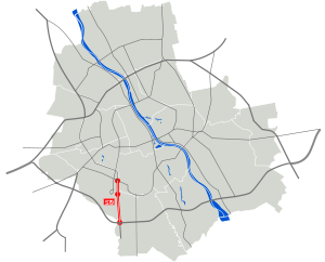
The Polish Droga ekspresowa S79 ( Polish for 'expressway S79') is a feeder road running in north-south direction to the southern Warsaw motorway ring ( S2 ), which passes east of Warsaw Chopin Airport and is intended to connect it. In the north, the S79 expressway will join a city road known as "Trasa NS", which will run from the motorway junction at Marynarska Street to the Armii Krajowej junction ( S7 / S8 ).
history
The section between the Warszawa-Marynarska and Warszawa-Południe nodes (S79; length: 4.3 km) was located together with the section between the Warszawa-Południe and Warszawa-Puławska nodes of the S2 (length: 3.9 km) from 2009 under construction until 2013 and should originally be completed by April 2012. Due to considerable construction delays, the short, 1.4 km long section from the Warszawa-Marynarska junction to the Warszawa- Lotnisko junction was initially opened to traffic on June 14, 2013. The complete completion and transfer of traffic took place together with the section of the S2 between the Warszawa junction -Aleja Krakowska and Warszawa-Poludnie on September 5, 2013.
Trasa NS
The Trasa NS expressway (Trasa Północ-Południe) is planned in a north-south direction to relieve the western Warsaw districts and as a bypass to the western motorway ring ( S2 / S7 / S8 ).
course
-
 Warszawa-Al. Armii Krajowej (cross with S7 and S8 )
 -
 Warszawa ul. Górczewska
 -
 Warszawa ul. Połczyńska
 -
 Warszawa-Aleje Jerozolimskie
 -
 Warszawa ul. Grójecka
 -
 Warszawa ul. Marynarska (continued as S79 )
Web links
- Construction of the S79 (Polish)
- Course of the S79
Individual evidence
- ^ History of the S79 at motorways.com (Polish) accessed on January 7, 2010
- ↑ Projektowana trasa NS na tle docelowego układu dróg ekspresowych w obrębie Warszawy. (PDF; 2.6 MB) - Map of the planned Warsaw route network

