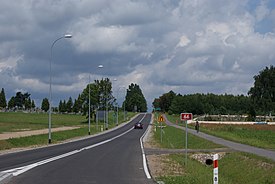
Droga krajowa 66
| Droga krajowa 66 in Poland | |||||||||||||||||||||||||||||||||||||||||||||||||||||||||||||||||||||||||||||||||||||||||||||||||||||||||||||

|
|||||||||||||||||||||||||||||||||||||||||||||||||||||||||||||||||||||||||||||||||||||||||||||||||||||||||||||
| Basic data | |||||||||||||||||||||||||||||||||||||||||||||||||||||||||||||||||||||||||||||||||||||||||||||||||||||||||||||
| Operator: |
|
||||||||||||||||||||||||||||||||||||||||||||||||||||||||||||||||||||||||||||||||||||||||||||||||||||||||||||
| Start of the street: |
Zambrów ( 52 ° 59 ′ N , 22 ° 15 ′ E ) |
||||||||||||||||||||||||||||||||||||||||||||||||||||||||||||||||||||||||||||||||||||||||||||||||||||||||||||
| End of street: |
Czeremcha ( 52 ° 28 ′ N , 23 ° 21 ′ E ) |
||||||||||||||||||||||||||||||||||||||||||||||||||||||||||||||||||||||||||||||||||||||||||||||||||||||||||||
| Overall length: | 114 km | ||||||||||||||||||||||||||||||||||||||||||||||||||||||||||||||||||||||||||||||||||||||||||||||||||||||||||||
| Development condition: | 1 × 2 lanes | ||||||||||||||||||||||||||||||||||||||||||||||||||||||||||||||||||||||||||||||||||||||||||||||||||||||||||||
|
Course of the road
|
|||||||||||||||||||||||||||||||||||||||||||||||||||||||||||||||||||||||||||||||||||||||||||||||||||||||||||||
The Droga krajowa 66 (short DK66 , pol. For 'Nationalstrasse 66' or 'Landesstrasse 66') is a national road in Poland . It leads from Zambrów in a south-easterly direction via Brańsk and Bielsk Podlaski to the Polish-Belarusian border crossing at Czeremcha . The total length is 114 km.
history

After the reorganization of the road network in 1985, several former state roads were assigned to the current course of the road. The section from Zambrów to Bielsk Podlaski became part of the national road 689. The section from Bielsk Podlaski to the state border became part of the national road 692.
With the reform of the numbering on May 9, 2001, the two sections were combined to form the new state road 66.
By 2009, the sections from Zambrów to Osipy-Lepertowizna (16.6 km) and from Kleszczele to the state border (10.5 km) were modernized. In 2010, work began on the 3.7 km long section in Brańsk and the section between Osipy-Lepertowizna and Szepietowo (14 km).
Important places along the route
- Zambrów
- Wysokie Mazowieckie
- Szepietowo
- Dąbrówka Kościelna
- Brańsk
- Bielsk Podlaski
- Kleszczele
- Czeremcha
See also
Web links
- GDDKiA website (Polish)
- Website of the Drogi Zaufania program (Polish)
Individual evidence
- ↑ Route of Landesstraße 66 on maps.google.de
- ↑ Resolution No. 192 of the Council of Ministers of December 2, 1985 on the selection of state roads. MP 1986 no. 3 poz. 16.
- ↑ Resolution No. 62 of the Council of Ministers of March 28, 2003 on the selection of state roads. MP 2003 no. 62 poz. 563.
- ↑ Drogi w programie: Droga krajowa nr 66 ( Memento from September 11, 2014 in the Internet Archive ) (Polish)
