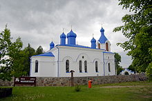
Kleszczele
| Kleszczele | ||
|---|---|---|

|
|
|
| Basic data | ||
| State : | Poland | |
| Voivodeship : | Podlaskie | |
| Powiat : | Hajnowski | |
| Gmina : | Kleszczele | |
| Area : | 46.71 km² | |
| Geographic location : | 52 ° 35 ' N , 23 ° 19' E | |
| Residents : | 1326 (December 31, 2016) | |
| Postal code : | 17-250 | |
| License plate : | BHA | |
| Economy and Transport | ||
| Street : | DK66 Bielsk Podlaski –Belarus | |
| DW685 Kleszczele– Hajnówka | ||
| DW693 Kleszczele– Siemiatycze | ||
| Rail route : | Czeremcha – Białystok | |
| Next international airport : | Warsaw | |
Kleszczele [ klɛʂˈt͡ʂɛlɛ ] ( Lithuanian Kleščelė ) is a town in the Hajnowski powiat of the Podlaskie Voivodeship in Poland . It is the seat of the town-and-country municipality of the same name with a little over 2,630 inhabitants.
Geographical location
The city is located in eastern Poland, about ten kilometers from the state border with Belarus , on the upper reaches of the Nurzec River .
history
The first written mention of today's Kleszczele comes from the 15th century. The town received town charter in 1523 from Sigismund I. Up until the 16th century all residents were from Volhynia and so there were two Orthodox churches at that time . In 1777 there was a major fire in which only 13 of the 181 houses were spared. By 1794 the number of houses had grown to 270. During the third partition of Poland , the place came to the Kingdom of Prussia in 1795 . After the Peace of Tilsit , Kleszczele became part of Russia . In 1873 it was connected to the rail network. After the end of the First World War , the place became part of the re-established Poland . During the Second World War it was occupied by the German Wehrmacht . On July 20, 1944, the 65th Army of the Byelorussian Front took the city and the place became part of Poland again. In 1950 Kleszczele lost its town charter. In 1993 the town was granted city rights again.
Incorporations
On the initiative of Queen Bona Sforza , the villages of Dobra Woda , Babicze-Kuzawa , Trubianka , Nurzec-Czeremcha and Kośna-Daszewicze were incorporated into Kleszczele as early as 1533 .
Population development
The following is a graphic representation of the population development.

local community
The town-and-country community (gmina miejsko-wiejska) includes the town of Kleszczele and 14 villages with school authorities.
Buildings
- An Orthodox church from 1870.
- A wooden bell tower from 1709
- The station building from 1900
traffic

State road 66 ( droga krajowa 66 ) runs through the city . After about twelve kilometers in a south-easterly direction, this leads to the border crossing to Belarus. After 25 kilometers in a northerly direction, the road leads through Bielsk Podlaski where it bends to the west. Furthermore, the provincial road 685 ( droga wojewódzka 685 ) begins in Kleszczele and leads in a north-easterly direction to Hajnówka . The Voivodeship Road 693 also begins in the city and leads to the southwest. It opens after 35 kilometers in Siemiatycze in the country Straße 19 .
There are regular bus services to Białystok , Bielsk Podlaski and Hajnówka.
The city is connected to the rail network. There is a direct connection to Białystok via Bielsk Podlaski. Hajnówka and Siedlce can be reached via a change in Czeremcha, seven kilometers to the south.
The nearest international airport is Warsaw Frédéric Chopin Airport , which is 170 kilometers to the west.
Web links
- Kleszczele website (Polish, English)
Individual evidence
- ↑ a b c Website of the city, Historia , accessed on January 16, 2010 ( WebCite ( Memento from January 16, 2010 on WebCite ))
- ↑ Szukacz.pl, Kleszczele - Informacje dodatkowe , accessed on January 16, 2010
-
↑ For 1533: City website, Historia , accessed on January 16, 2010 ( WebCite ( Memento from January 16, 2010 on WebCite ))
For June 30, 2009: Główny Urząd Statystyczny "LUDNOŚĆ - STAN I STRUKTURA W PRZEKROJU TERYTORIALNYM", as of dated June 30, 2009 ( WebCite ( Memento from December 13, 2009 on WebCite )) - ↑ Website of the city, Rozkład jazdy - komunikacja publiczna , accessed 16 January 2010

