
Motta Palousa
| Motta Palousa | ||
|---|---|---|
 Motta Palousa, recorded by Crap digls Anghels |
||
| height | 2143.6 m above sea level M. | |
| location | Canton of Graubünden , Switzerland | |
| Mountains | Albula Alps | |
| Dominance | 0.22 km → Piz Mitgel | |
| Notch height | 33 m ↓ Scharte towards Piz Mitgel, right next to Motta Palousa | |
| Coordinates | 765 882 / 167832 | |
|
||
| Normal way | About Promastgel | |

The Motta Palousa ( Rhaeto-Romanic in the idiom Surmiran motta for "hill", "hill", "dome" and palousa from the Latin pilosus for "hairy") is a lookout point south of Surava in the canton of Graubünden in Switzerland with an altitude of 2143, 6 m above sea level M. The Motta Palousa forms the north-western end of the Bergüner Stocks mountain range and offers a comprehensive view of the Schin , Domleschg , Lenzerheide and Albula valley as far as Davos Monstein .
Location and surroundings

The Motta Palousa belongs to the Bergüner sticks , a subgroup of the Albula Alps . It separates the Albula Valley in the north from the Oberhalbstein in the southwest . The municipal boundary between Albula / Alvra and Surses runs over the Motta Palousa.
The Motta Palousa is located in the middle of Parc Ela , a 600 square kilometer nature park opened in 2006 .
Valley locations are Surava , Alvaneu , Cunter and Tiefencastel . A common starting point is Promastgel .
Routes to the summit
About PromastgelNormal route
About spinacha
About Aclas
About Alp Era
|

panorama

gallery

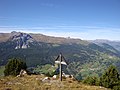
Cross at Crap digls Anghels, 400 m south of Motta Palousa
View to the west


literature
- National map of Switzerland, sheet 1236 Savognin, 1: 25000, Federal Office of Topography, 2003 edition
Web links
- Panorama from the Motta Palousa
- www.hikr.org Various tour reports
Individual evidence
- ↑ Andrea Schorta: How the mountain got its name . Small Rhaetian name book with two and a half thousand geographical names of Graubünden. Terra Grischuna Verlag, Chur and Bottmingen / Basel 1988, ISBN 3-7298-1047-2 , p. 111 .
- ↑ Bike & hiking bus timetable on the Savognin Bivio Albula holiday region website, accessed on April 8, 2018