Piz Kesch
| Piz Kesch | ||
|---|---|---|
|
Piz Kesch recorded by Älplihorn |
||
| height | 3417.7 m above sea level M. | |
| location | Graubünden , Switzerland | |
| Mountains | Albula Alps | |
| Dominance | 23 km → Piz Tschierva | |
| Notch height | 1502 m ↓ Lukmanier Pass | |
| Coordinates | 786 409 / 166.24 thousand | |
|
|
||
| First ascent | September 7, 1846 by Johann Coaz , J. Rascher, Chr. Casper and JR Tscharner | |
| Normal way | About the northeast spur | |
The Piz Kesch ( Rhaeto-Romanic [ pit͡s deʃˈt̠͡ɕa ]) is 3417.7 m above sea level. M. the highest mountain in the Albula Alps and the municipalities of Bergün and Zuoz in Switzerland . With a notch height of more than 1500 meters, Piz Kesch is one of the so-called ultra prominent peaks . Thanks to its central location, it is one of the most promising mountains in the Graubünden Alps and is therefore often visited. The view extends from the Ötztal Alps and Val Gardena Dolomites , the Ortler and Adamello over the Bernina group to the Valais and Bernese four-thousanders.
From the highest point in the west ( 3417 m above sea level ) a partly sharp ridge stretches towards the southeast to the central summit ( 3405 m above sea level ). From there the ridge continues northeast to Aguoglia d'Es-cha , also called Keschnadel ( 3386 m above sea level ).
Location and surroundings
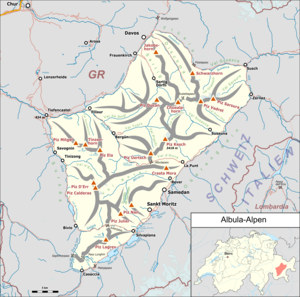
The Piz Kesch belongs to the Kesch group, a subgroup of the Albula Alps . The municipal boundary between Bergün Filisur and Zuoz runs above the summit .
The neighboring peaks include the Kesch Pitschen in the north, the Piz Porchabella and the Piz Val Müra in the east, the Piz Cotschen , the Piz Pischa , the Piz Blaisun and the Piz Üertsch in the south, as well as the Tschimas da Tisch , the Piz Darlux and the Piz Fregslas in the west.
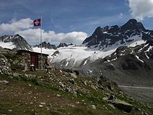
From north to east, Piz Kesch is surrounded by a glacier , the Vadret da Porchabella . To the southeast of the mountain is another glacier, the Vadret d'Es-cha .
The valley locations are Bergün and Madulain . Frequent starting points are the Kesch hut and the Es-cha hut .
Origin of the name
The German name "Kesch" probably comes from the personal name Quesch , a short form of Arquisch , Hartwig .
The Romance name Es-cha comes from the Gallic word asc , collated with asca for “willow”.
Routes to the summit
The easiest ascent is from the Kesch hut ( 2625 m above sea level ). On the ascent, you first walk over a glacier up to approx. 200 meters below the summit. At point 3008, Porta d'Es-cha, the route from the Es-cha hut joins it. The ascent to the summit is only recommended with crampons and ice ax in winter.
The Keschhütte can be reached from Bergün or via the Sertigpass from Sertig in the Davos landscape. The longest access is from the Engadine side, coming from S-chanf. A multi-day hike is called the Kesch Trek and leads from Dischma via Scalettapass from the north to the Keschhütte. It connects the Keschhütte with the Es-cha-Hütte and thus both huts on Piz Kesch.
Summer routes
The Piz Kesch was climbed on countless routes and variants, of which only two are used regularly in our time. The other routes are avoided because of the poor quality of the rock, which is disproportionate to the difficulty.
About the northeast spur
Route of first-time climbers
- Starting point: Keschhütte ( 2632 m ) or Es-cha-Hütte ( 2594 m )
- Via: From the Keschhütte to almost the Porta d'Es-cha ( 3008 m ), from the Es-cha-Hütte via the Porta d'Es-cha, through the glacier basin between the main summit and the Keschnadel to its northwest corner, then to the northeast ridge.
- Difficulty: WS
- Time required: 3 hours from the Keschhütte and from the Es-cha hut, 1½ hours from the Porta d'Es-cha
- Note: The rock in the climbing areas is quite solid, the rubble sections in between require careful walking because of the risk of falling rocks.
Over the Keschgrat
First ascent: Paul Güssfeld with Hans Grass, September 28, 1877 (perhaps already Jakob Planta, 1863)
- Starting point: Keschnadel ( 3386 m )
- Difficulty: WS
- Time required: 1¾ hours
- To the needle:
Over the Cotschengrat
First ascent: David Stokar and Karl Linnebach with Peter Mettier, July 26, 1896
- Starting point: Piz Cotschen ( 3195 m )
- Difficulty: ZS-
- Time required: 2 hours
- To Piz Cotschen:
- Note: Since the rock is not beyond doubt, the route is rarely used.
Winter routes
From the Es-cha hut ( 2594 m )
- Via: Porta d'Es-cha ( 3008 m ), Vadret da Porchabella, ski depot at approx. 3270 m, then to the northeast ridge
- Exposures: SO, O
- Difficulty: ZS-
- Time required: 3½ hours
From the Keschhütte ( 2632 m )
- Via: Almost to the Porta d'Es-cha and then as in Von der Es-cha-Hütte
- Exposures: N, O
- Difficulty: WS +
- Time required: 3 hours
panorama
literature
- Manfred Hunziker: Club Guide, Bündner Alpen, Volume VI (From Septimer to Flüela). 3. Edition. Verlag des SAC, 2000, ISBN 3-85902-187-7 , pp. 301-306.
- Vital Eggenberger: Ski tours Graubünden South. Verlag des SAC, 2010, ISBN 978-3-85902-301-7 , pp. 172-174.
- National map of Switzerland, sheet 1237 Albula Pass, 1: 25000, Federal Office of Topography, 2011 edition.
Web links
- Panorama from Piz Kesch
- Piz Kesch tour reports and photos
Individual evidence
- ↑ See list of the most prominent mountains in the Alps .
- ↑ Manfred Hunziker: Club Guide, Bündner Alpen, Volume VI (From Septimer to Flüela). 3. Edition. Verlag des SAC, 2000, ISBN 3-85902-187-7 , pp. 301-302.
- ↑ Andrea Schorta : How the mountain got its name (Small Rhaetian Name Book with two and a half thousand geographical names of Graubünden) . Terra Grischuna Verlag, 1988, ISBN 3-7298-1047-2 , p. 96.
- ↑ Andrea Schorta: How the mountain got its name (Small Rhaetian Name Book with two and a half thousand geographical names of Graubünden) . Terra Grischuna Verlag, 1988, ISBN 3-7298-1047-2 , p. 85.
- ↑ Hiking Switzerland, Graubünden; Kesch Trek on Graubünden Holidays ( Memento of the original from November 9, 2011 in the Internet Archive ) Info: The archive link has been inserted automatically and has not yet been checked. Please check the original and archive link according to the instructions and then remove this notice.
- ↑ Manfred Hunziker: Club Guide, Bündner Alpen, Volume VI (From Septimer to Flüela). 3. Edition. Verlag des SAC, 2000, ISBN 3-85902-187-7 , p. 302.


