Piz Blaisun
| Piz Blaisun | ||
|---|---|---|
|
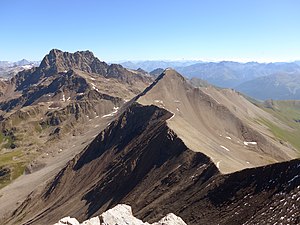
Piz Blaisun from the southwest, from Piz Üertsch, Piz Kesch to the left |
||
| height | 3200 m above sea level M. | |
| location | Graubünden , Switzerland | |
| Mountains | Albula Alps | |
| Notch height | 236 m ↓ Deepest saddle between Piz Üertsch and Piz Blaisun | |
| Coordinates | 785 712 / 164 192 | |
|
|
||
| rock | Lias slate | |
| Normal way | From Fuorcla Pischa over the north ridge | |
The Piz Blaisun ( 3200 m above sea level ) is a peak in the Albula Alps in the Swiss canton of Graubünden, northeast of the Albula Pass . It forms a striking slate pyramid, but is still somewhat overshadowed by its higher neighbors, both about two kilometers away: Piz Üertsch to the west ( 3267 m above sea level ) and Piz Kesch ( 3418 m above sea level ) to the north . ), the highest Albula peak. These three mountains differ conspicuously from a geological point of view: the Piz Üertsch consists of Trias limestone and dolomite , the Piz Blaisun of Lias slate and the Piz Kesch of gneiss .
Location and surroundings
After Piz Üertsch, Piz Blaisun is the second highest peak in the chain that runs from west to east and which frames the Albula pass road in the north. The summit sends out four ridges that run almost exactly in the cardinal directions. The west ridge connects the summit with the Piz Üertsch, the east ridge runs to Fuorcla Gualdauna and separates the Val d'Es-cha in the north from the Val d'Alvra in the south. The short south ridge ends after a little more than a kilometer in the direction of Val d'Alvra , the north ridge descends to Fuorcla Pischa , in the further course of the ridge Piz Pischa and Piz Kesch rise up. The north and east ridge are part of the Rhine-Danube watershed . There are two small lakes southwest of the summit.
Alpinism
In contrast to the neighboring Piz Üertsch, the mountain is comparatively easy to climb from all sides. The easiest ascent starts at Punt Granda on the Albula pass road about 2½ kilometers east of the top of the pass to an altitude of 2255 m. First you climb in a north-easterly direction over the pastures of the Alps d'Alvra to Fuorcla Gualdauna (2486 m). The path now crosses the upper Val d'Es-cha in a gentle up and down direction in a northerly direction , crosses the Ova Pischa brook until you reach the fork of the path to Fuorcla Pischa - the continuation of the path in a northerly direction leads to what is already visible from afar Chamanna d'Es-cha . To Piz Blaisun, follow the path in an easterly direction, leave it at Fuorcla Pischa (2867 m) and briefly reach the summit via the northern ridge of Piz Blaisun. The ascent time is given as 3½ hours, the difficulty rating on the SAC hiking scale is T3 +.
In addition to this marked ascent path, there are also some pathless climbs that are also not very difficult. For example, you can also reach the summit more directly from the height of the Albula Pass. To do this, you cross from the top of the pass over Weiden in a north-easterly direction to the high valley between Piz Üertsch and Piz Blaisun, known as the Fuora da l'Üertsch . Now you can either aim for the last deep cut of the ridge west of Piz Blaisun through this valley and reach the summit without difficulty via the west ridge. Alternatively, you can also reach your destination via the wide south ridge.
The Piz Blaisun can also be climbed as part of a ski tour.
Literature and map
- Peter Deuble: Light 3000 in Switzerland. Bruckmann Verlag, Munich 2011, ISBN 978-3-7654-4959-8 .
- National map of Switzerland, sheet 1237 Albula Pass, 1: 25,000, Federal Office for Topography
Individual evidence
- ^ Charles Knapp, Maurice Borel, Victor Attinger, Heinrich Brunner, Société neuchâteloise de geographie (editor): Geographical Lexicon of Switzerland . Volume 1: Aa - Emmengruppe . Verlag Gebrüder Attinger, Neuenburg 1902, p. 276, keyword Blaisun, Piz ( scan of the lexicon page ).
- ↑ Map section Piz Blaisun at map.geo.admin.ch
- ↑ Peter Deuble: Light 3000 in Switzerland. Bruckmann Verlag, Munich 2011, ISBN 978-3-7654-4959-8 , pp. 64-66.
- ^ Thomas Wilken: Lonely summit destinations in Graubünden . epubli-Verlag, 2020, ISBN 978-3-7502-8125-7 , Tour 12 ( limited preview in the Google book search).
- ^ Rudolf Weiss, Siegrun Weiss: Engadin: Scuol - Zernez - Samedan - Pontresina - St. Moritz. 50 ski tours. Bergverlag Rother, 3rd edition, Munich 2011, ISBN 978-3-7633-5901-1 , p. 92 ( limited preview in the Google book search).
Web links
- Piz Blaisun on hikr.org

