
Aroser Rothorn
| Aroser Rothorn | ||
|---|---|---|
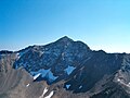
 The Aroser Rothorn seen from the northeast |
||
| height | 2980.2 m above sea level M. | |
| location | Canton of Graubünden ( Switzerland ) | |
| Mountains | Plessur Alps | |
| Dominance | 13.1 km → Piz Mitgel | |
| Notch height | 1349 m ↓ Wolfgang Pass | |
| Coordinates | 766 236 / 178 604 | |
|
||
| rock | crystalline (Silvretta blanket) | |
| First ascent | unknown | |
| Development | Mountain hiking trail (unmarked) | |

The Aroser Rothorn ( advises Piz Cotschen ) is at 2980.2 m the highest point in the Plessur Alps in the canton of Graubünden in Switzerland . At the same time, it is the highest point in the municipalities of Arosa , Lantsch / Lenz and Albula / Alvra , the borders of which converge at the summit. This means that the mountain is also on the border between the districts of Plessur and Albula .
Location and description
Three ridges start from the wide, undeveloped summit , located in the crystalline region , to the northeast ( Erzhorn ), south ( Pizza Naira - Lenzer Horn ) and northwest ( Parpaner Rothorn / Älplihorn ). The north and west flanks consist of rock steps of poor quality, from the south-east scree slopes reach up to the ridges. From the summit, the visitor can enjoy a splendid panoramic view of the whole of Central Grisons and in particular of the Arosa mountain shell, which is bordered by the Aroser Weisshorn in the northwest and the Strela chain in the east, which is practically impossible to see from the neighboring Parpaner Rothorn. Due to its outstanding location will be on August 1 ( Swiss National Day of Arosa Rothorn regularly highly visible) on the hilltop bonfires inflamed.
Routes to the summit
The Aroser Rothorn has been accessible from Arosa on a challenging hiking trail over the Erzhornsattel since 1905 . You can choose between the route over the Älplisee ( T4 ) or via Welschtobel - Ramozhütte ( T3 ). About a kilometer northwest of the Aroser Rothorn is the summit of the Parpaner Rothorn. Via the northwest ridge connecting the two peaks, the Aroser Rothorn can also be easily climbed from Lenzerheide on a path that is no longer officially marked and partly exposed ( T4 ). Finally, it is also possible to climb the southern ridge from the Ramozhütte, the Furcletta ( T4 ) and from the Alp Sanaspans ( T5 ). In winter, the main ascent leads from the Ramozhütte via Sessel to the uppermost part of the northeast ridge (route 191). In good snow conditions, the route over the northwest ridge can also be chosen from the Parpaner Rothorn (walk).
Tourist use

The first known winter ascent of the Rothorn was made by the Egger brothers from Basel together with Ed. Geigy 1886 with snowshoes from Arosa. In 1893 Fritz and Carl Egger, together with E. Toutain and Carl Stäubli, also climbed the mountain on skis for the first time. From 1914 to around the mid-twenties of the last century, summer ski races a.o. took place at the Aroser Rothorn. a. with world champion David Zogg . As a result, the Rothorn developed into a popular and often visited ski and hiking mountain, which, however, was never mechanically developed - mainly for reasons of nature and landscape protection. The Arosa Lenzerheide ski arena, which was built in 2013/14, does not affect the area around the Arosa Rothorn.
Historical
On the Aroser Rothorn and the Erzhorn , iron ores , radiolarite and other mineral resources were mined as early as the Middle Ages and smelted in the smelting furnaces in the Isel near Arosa. Because of this early development of the area and because the summit can be climbed relatively easily on various routes, the first ascent of the Aroser Rothorn has remained unknown. What is certain is that the geologist Conrad Escher von der Linth explored the area in 1806 and climbed the Rothorn. In 1879 and 1959 ibex were released on the Arosa Rothorn as part of attempts to reintroduce them .
photos
North face seen from the Älplihorn
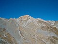
Southeast view

Northwest ridge, view from Parpaner Rothorn

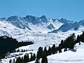
Rothorn group from the northeast
Rothorn (right) with Erzhorn via Tschuggen


swell
- Manfred Hunziker: Ringelspitz / Arosa / Rätikon, Alpine Tours / Bündner Alpen , Verlag des SAC 2010, ISBN 978-3-85902-313-0 , pp. 328-330.
- The mountains of the canton of Graubünden , Verlag Rüegger, Chur / Zurich 2003, ISBN 3-7253-0742-3 , pp. 16-19.
- Ueli Haldimann (ed.): Hermann Hesse , Thomas Mann and others in Arosa - texts and images from two centuries , AS Verlag und Buchkonzept AG, Zurich 2001, ISBN 3-905111-67-5 , p. 9 ff.
- SAC Club Guide, Bündner Alpen 1, Tamina and Plessur Mountains , Verlag des SAC, 4th edition 1988, p. 324 f.
- Alpinwandern Graubünden Nord, SAC-Verlag Bern, 1st edition 2008, p. 324 ff.
- Hans Danuser : Arosa - as it was then (1850-1907) , vol. 1, self-published by Danuser, Arosa 1997, p. 28 ff., 88 f.
- Hans Danuser: Arosa - as it was then (1907-1928) , vol. 2, self-published by Danuser, Arosa 1998, p. 174 f.
- Hans Danuser, Ruedi Homberger: Arosa und das Schanfigg , self-published by Danuser / Homberger, Arosa 1988, p. 173 f.
- JB Casty: Arosa - From the local history of the world-famous health resort , Verlag Kur- und Verkehrsverein Arosa, Arosa 1959/60, p. 118 f.
- Fritz Maron: The history of the Arosa skiing, Verlag Buchdruckerei Arosa, Arosa 1933, p. 17 ff.