Ächerli Pass
| Ächerli Pass | |||
|---|---|---|---|
|
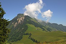
Ächerlipass; View in east direction to the Buochserhorn |
|||
| Compass direction | west | east | |
| Pass height | 1398 m above sea level M. | ||
| Canton | Obwalden | Nidwalden | |
| Valley locations | Kerns | Dallenwil | |
| expansion | Street | ||
| Built | ? | ||
| Lock | November - April | ||
| profile | |||
| Ø pitch | 7.5% (895 m / 12 km) | 9.7% (972 m / 10 km) | |
| Max. Incline | 16% | 16% | |
| Map (Switzerland) | |||
|
|
|||
| Coordinates | 668 314 / 195 283 | ||
The Ächerli is a Swiss pass that connects Wisserlen , a district of the municipality of Kerns in the canton of Obwalden , with Dallenwil in the canton of Nidwalden . The lowest point of the pass is at an altitude of 1398 m above sea level. M. , but the highest point of the pass road is a little further south at an altitude of 1458 m above sea level. M. The asphalt road with a total length of 19.6 kilometers has a gradient of up to 16 percent. With the exception of passing points, it is usually only one lane and quite narrow.

From the pass road, mountains such as the Pilatus , the Rigi , the Stanserhorn , the Buochserhorn and the summit of the Titlis can be seen.
North of the pass, on the ridge to the Stanserhorn, the Holzwang Chapel, built in 1903/04, stands at 1,444 m . Further down, in the Wiesenberg district , is the pilgrimage chapel of St. Maria, built around 1754. It stands on the site of a hermitage mentioned in the 14th century.
See also
Web links
- Ächerli Pass (Switzerland) by motorcycle Photos, map and description of the Ächerli Pass on the private website ryter-hermann.ch
- Ächerli pass on hikr.ch
Individual evidence
- ↑ Holzwang Chapel Description on wirzweli.ch accessed on January 9, 2019
- ↑ Wiesenberg Chapel Description on wirzweli.ch accessed on January 9, 2019


