Buochserhorn
| Buochserhorn | ||
|---|---|---|
|
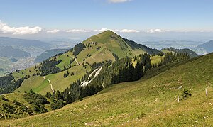
View from the Musenalp over the Bleikigrat to the Buochserhorn |
||
| height | 1806 m above sea level M. | |
| location | Nidwalden , Switzerland | |
| Mountains | Uri Alps | |
| Dominance | 4.28 km → Schinberg | |
| Notch height | 227 m ↓ bear traps | |
| Coordinates | 675 369 / 199860 | |
|
|
||
The Buochserhorn is a mountain in the central Swiss canton of Nidwalden with an altitude of 1806 m above sea level. M. The name of the mountain comes from the town of Buochs , which lies on the north side at the foot of the mountain and on Lake Lucerne .
geography
The mountain belongs to the Urner Alps , according to SAC classification to the Alpine region of the Unterwaldner Voralpen , and consists of limestone layers over a flysch base . Together with the Stanserhorn in the west, the Buochserhorn marks the entrance from the plain near Stans and Oberdorf into the Engelbergertal . In addition to the narrow valley level on the Engelberger Aa , the mountain slope near the village of Büren climbs steeply to the summit. The northern foothills of the Buochserhorn with the foothills of Nollen ( 1347 m above sea level ) and Hörndli ( 1390 m above sea level ) touches the southern shore of Lake Lucerne near Hobiel . On the east side, the valley of the Träschlibach and the Lielibach separates the mountain range from the summit of the Klewenalp . In the southeast, the Buochserhorn is connected to the Musenalp plateau via a saddle and the Bleikigrat ; in the south, deep under the rock face of the Gibelberg, there are gorges of the Buoholzbach and the village of Niederrickenbach .
The municipal areas of Buochs, Oberdorf and Beckenried meet at the Buochserhorn .
The steep valley of the Rübibach, which in the past had often caused floods and debris flows near Buochs, has been used since the 19th century to protect the densely built-up town center and later also the A 2 motorway through numerous hydraulic engineering measures such as abdominal barriers , a large retention basin and slope stabilization has been secured. There are also barriers in other steep gullies in the forest such as the Herdmattligraben and the Klein Lauigraben.
The Buochserwald on the steep northern flank of the Buochserhorn is maintained as a protective forest for the settlement in the valley.
Land survey
At the southern foot of the mountain, next to the ravine of the Buoholzbach, the geographical center of the canton of Nidwalden is marked.
The summit of the Buochserhorn has served as a second-order triangulation point since the beginning of geodetic surveying in Switzerland in the mid-19th century . It has been marked with an iron pyramid since the Unterwalden survey campaign from 1916 to 1919.
Summit cross
The Buochserhorn Cross , a 12-meter-high metal summit cross, is located on the mountain top and can be easily seen from the Lucerne region . As a replacement for an older wooden alpine cross, the Nidwalden Young Team Association erected the new mountain cross in 1961. The extensive building material was transported to the construction site with the Dallenwil- Niederrickenbach aerial cableway , a transport rope and load carriers. The solemn inauguration of the cross took place on October 1, 1961. Several times since then, storm winds have severely damaged the cross, which is anchored with eight steel cables.
tourism
Thanks to its exposed location as a mountain ledge, the Buochserhorn offers a panoramic view of the Central Swiss Alps in the south and Lake Lucerne with the mountains of the pre-Alps in the north. In contrast to the Stanserhorn, which can be reached with the Stanserhorn-Bahn , only hiking trails lead to the Buochserhorn. The only cable cars nearby are the aerial tramway from Dallenwil to Niederrickenbach and the cable car from Niederrickenbach to the Musenalp. An agricultural road connects the Alp Ochsenweid, high on the western slope of the Buochserhorn, with the Engelbergertal. The mountain is a popular area for mountain bikers who can ride routes from Buochs, Dallenwil, Niederrickenbach and Beckenried.
View from the summit of the Buochserhorn to the plain of Buochs and Ennetbürgen ; in the background the Bürgenstock
Web links
- Buochserhorn on hikr.org
Individual evidence
- ↑ a b c d e Heights & Uferort according to geo.admin.ch
- ^ H. Knecht: The Buochserhorn – Musenalp cliff group and its documents. Basel 1925. PDF
- ↑ Natural Hazard Management Rübibach Buochs ( Memento of the original dated August 29, 2016 in the Internet Archive ) Info: The archive link was inserted automatically and has not yet been checked. Please check the original and archive link according to the instructions and then remove this notice.
- ^ Buochser Wald, Buochs cooperative corporation
- ^ Geographical center of the canton
- ↑ Hans Zölly : History of the geodetic basis for maps and measurements in Switzerland. Wabern 1948. p. 161
- ↑ Hans Zölly: Geodetic basics of measurements in train and Schwyz. Historical overview. In: Swiss Journal for Surveying and Cultural Technology, 1932, pp. 161–174.
- ^ History of the Buochserhorn Cross
- ↑ Dallenwil – Niederrickenbach aerial cableway
- ↑ Musenalp Railway


