
Oberdorf NW
| NW is the abbreviation for the canton of Nidwalden in Switzerland and is used to avoid confusion with other entries in the name Oberdorf . |
| Oberdorf | |
|---|---|
 |
|
| State : |
|
| Canton : |
|
| District : | No district division |
| BFS no. : | 1508 |
| Postal code : | 6370 Oberdorf 6382 Büren 6383 Niederrickenbach |
| Coordinates : | 671807 / 200618 |
| Height : | 455 m above sea level M. |
| Height range : | 443–1806 m above sea level M. |
| Area : | 16.20 km² |
| Residents: | 3124 (December 31, 2018) |
| Population density : | 193 inhabitants per km² |
|
Proportion of foreigners : (residents without citizenship ) |
7.0% (December 31, 2,015) |
| Website: | www.oberdorf-nw.ch |
 Oberdorf NW |
|
| Location of the municipality | |
  |
|
Oberdorf is a municipality in the canton of Nidwalden in Switzerland .
geography
Oberdorf is made up of the three districts of Oberdorf (upper part of the canton capital Stans ), the hamlet of Büren and the mountain village of Niederrickenbach and is located at the entrance to the Engelberg Valley . The area of the municipality extends from the fertile plain of the Stanser Boden to the high alpine pastures and Alps on the breeze. The southwest flank of the Buochserhorn ( 1806 m above sea level ) also belongs to Oberdorf .
Only 6.7% of the entire municipal area is settlement area. A large part of the community area is covered by wood and forest with 38.3%. An even larger area of 53.0% is used for agriculture. A mere 1.9% are unproductive areas.

population
Localities
Oberdorf has changed a lot, especially in the last 30 years. Until then, the population consisted almost exclusively of farmers, craftsmen and some employees from military companies. From the 1970s, however, a strong construction boom set in, which brought the community a high level of immigration and new, scattered residential areas. In Oberdorf, these were mainly large-scale developments that formed around the Wil area. Because the Oberdorf district used to consist almost entirely of farms, it has no actual town center. In recent years, however, the municipal council has made great efforts to turn the scattered settlements into a village center.
In Büren mainly medium-sized and smaller buildings were built, which could be integrated relatively well into the existing village image. The center of the village is made up of the church, the schoolhouse and the grocery store.
The car-free but remote and best reached by cable car Niederrickenbach, on the other hand, had to fight against emigration in recent years. Since the jobs are almost exclusively in agriculture and alpine farming and the birth rate is falling, fewer and fewer young people stay in this idyllic pilgrimage village. The center is here around the Benedictine convent.
Population development
The population grew by 8.9% from 1850 to 1860. Despite a high birth surplus, it then fell for several decades (1860–1888: -5.5%). Migration to more industrialized communities was the main reason. After a brief growth spurt from 1888 to 1900, a decade-long phase of stagnation followed (1900-1930). In the period from 1930 to 1960 there was a moderately rapid population increase (1930–1960: + 25.9%). Since then the population has been growing rapidly. It doubled within half a century (1960–2010: + 103.9%). Population growth has slowed since 2010. The reasons for the rapid growth were the improvement in public transport services and, above all, the construction of the A2 . The community also became attractive for commuters because of its proximity to the Nidwalden capital, Stans, and the low building land prices.
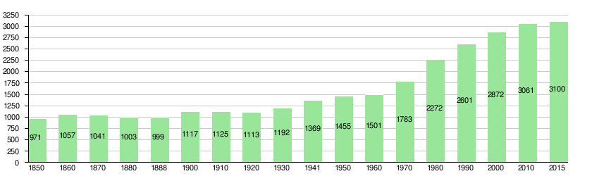
Population development of Oberdorf since 1850 Source: Population censuses (1850–2000 Federal), Federal Statistical Office (2010 and 2015)
languages
The population speaks a highly Alemannic dialect. Nidwalden German is still widely spoken. Almost the entire population speaks German as the everyday language. In the last census in 2000, 95.2% said German, 0.8% Albanian and 0.7% English were the main languages.
Religions - denominations
The population used to be fully members of the Roman Catholic Church. The denominational relationships in 2000 still show the original structure despite the mixture. 2,369 people were Catholic (82.49%). There were also 8.15% Protestant and 0.80% other Christians, 1.15% Muslims and 3.86% non-denominational. 101 people (3.52%) did not provide any information about their creed. Until a few decades ago, almost the entire population was Catholic. The secularization of the church and the high level of immigration from other parishes and abroad has led to a rapid increase in other denomination groups in Oberdorf.
Origin - nationality
At the end of 2015, 2,878 (92.84%) of the residents were Swiss nationals. Most of the immigrants come from Central and Western Europe (Germany and Great Britain), Southern Europe (Italy and Portugal), Sri Lanka and the former Yugoslavia (Serbia, Montenegro, Kosovo, Croatia and Bosnia-Herzegovina). At the 2000 census, 2,731 people (95.09%) were Swiss citizens; 98 of them had dual citizenship.
age structure
The church has a high percentage of younger people. While the proportion of people under the age of twenty makes up 28.86% of the local population, 13.79% are senior citizens (60 years and older). The largest age group is made up of people between 30 and 44 years of age.
The last census in 2000 showed the following age structure:
| Age | 0–6 years | 7-15 years | 16-19 years | 20-29 years | 30–44 years | 45–59 years | 60–79 years | 80 years and more |
| number | 258 | 399 | 172 | 363 | 707 | 577 | 341 | 55 |
| proportion of | 8.98% | 13.89% | 5.99% | 12.63% | 24.62% | 20.09% | 11.87% | 1.92% |
economy
Agriculture originally dominated Oberdorf. Small industrial companies were added in the 19th century. The Swiss Army , which operates barracks in Wil , has also been an important employer . This was recently converted to accommodate the Swissint competence center (Command for International Operations of the Swiss Armed Forces) and is now used for Swisscoy training. However, since the Army XXI reform , the Oberdorf location has been called into question.
In Oberdorf there were (2005) 996 employees in 152 companies. 21.5% of the employees in Oberdorf worked in agriculture / forestry / fishing (sector 1), 53.2% in industry and trade (sector 2) and 25.3% in service companies (sector 3). The unemployment rate in 2007 was 1.09%.
In 2017, of the 1,319 employees, 855 were male and 464 were female. The numbers for the 3 sectors are as follows:
| Companies 1st sector |
Employees 1st sector |
Full-time positions 1st sector |
Companies 2nd sector |
Employees 2nd sector |
Full-time positions 2nd sector |
Companies 3rd sector |
Employees 3rd sector |
Full-time positions 3rd sector |
Operations total |
employees Total |
Total full-time positions |
|
| number | 57 | 158 | 100 | 37 | 576 | 519 | 94 | 585 | 443 | 188 | 1319 | 1062 |
| proportion of | 30.32% | 11.98% | 9.42% | 19.68% | 43.67% | 48.87% | 50.00% | 44.35% | 41.71% | 100% | 100% | 100% |
| Source: Federal Statistical Office; Statistics of the company structure STATENT, workplaces and employees by municipality and economic sector | ||||||||||||
In 2000 there were 704 people in employment in Oberdorf. Of these, 343 (48.72%) were locals and 361 were commuters. Most of the commuters came from the region; namely from Stans (18.0%), Buochs (12.2%), Wolfenschiessen and Dallenwil (11.9% each), Ennetbürgen (8.9%) and Stansstad (6.6%). In the same year, 1,595 people from Oberdorf were gainfully employed. Thus 1,252 people worked in other municipalities. 558 people (= 44.6% of all commuters) commuted to the Nidwalden main town of Stans, 134 people (10.7%) to the city of Lucerne, 51 people (4.1%) to Buochs, 39 people (3.1%) to Stansstad %), according to Kriens 38 people (3.0%), according to Hergiswil 36 people (2.9%), according to Emmen 34 people (2.7%), according to Sarnen 32 people (2.6%), according to Engelberg 30 People (2.4%) and after Dallenwil and Ennetbürgen 28 people each (2.2% each). Thus around 60% of the people commuted within the agglomeration of Stans, a strong minority of almost 30% to the agglomeration of Lucerne (city of Lucerne, Kriens, Hergiswil, Emmen etc.) and a smaller minority of 7.5% to the canton of Obwalden (Engelberg and the Sarnen agglomeration).
traffic
The municipality of Oberdorf is connected to the public transport network through the PostBus course Stansstad (train station) - Stans (train station) - Büren (church square). This bus route replaces the Oberdorf and Büren stops of the Zentralbahn , which were canceled in 2002 . In addition, the A2 motorway can be reached in a few minutes.
Attractions
photos

Local government
Schoolhouse in Oberdorf

Spinning top in Wil

District of Büren

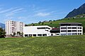
Schoolhouse in Büren

Maria Rickenbach Monastery

Pilgrimage Church of Maria Rickenbach


Web links
- Official website of the municipality of Oberdorf
- Peter Steiner: Oberdorf (NW). In: Historical Lexicon of Switzerland .
Individual evidence
- ↑ Permanent and non-permanent resident population by year, canton, district, municipality, population type and gender (permanent resident population). In: bfs. admin.ch . Federal Statistical Office (FSO), August 31, 2019, accessed on December 22, 2019 .
- ↑ https://secure.i-web.ch/dweb/nw/de/onlinemain/publikationen/?pubid=8254&action=info ( page no longer available , search in web archives ) Info: The link was automatically marked as defective. Please check the link according to the instructions and then remove this notice.
- ↑ fahrplanfelder.ch: PDF , accessed on October 20, 2010
Beckenried | Buochs | Dallenwil | Emmetten | Ennetbürgen | Ennetmoos | Hergiswil | Oberdorf | Stans | Stansstad | Wolf shooting
Former municipality: Büren
Canton of Nidwalden | Districts | Municipalities in the canton of Nidwalden