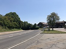
Albispass
| Albispass | |||
|---|---|---|---|
|
Albispass, in front Rüschlikon |
|||
| Compass direction | North | south | |
| Pass height | 790 m above sea level M. | ||
| Canton | Zurich | ||
| Watershed | Sihl → Limmat → Rhine | Reppisch → Limmat → Rhine | |
| Valley locations | Langnau am Albis | Mettmenstetten | |
| expansion | Street | ||
| Built | 1835-1839 | ||
| Lock | - | ||
| profile | |||
| Ø pitch | 7.7% (308 m / 4 km) | 4.0% (322 m / 8 km) | |
| Max. Incline | 8th % | 8th % | |
| Map (Switzerland) | |||
|
|
|||
| Coordinates | 681 913 / 236688 | ||
The Albispass is a road pass in the canton of Zurich . It leads from Langnau am Albis over the Albis to Mettmenstetten ; the pass is at 790 m above sea level. M.
geography
The sign at the pass indicates a height of 793 m above sea level. M. , but because the reference point for height measurements in Switzerland has changed, the lower height information is correct according to the current measurement method.
The Albispass connects the Sihltal with the Knonaueramt .
history
The forerunner of the Albis Pass was probably the more gently accessible Schnabelücke, which at 803 m above sea level. M. is only slightly higher. It lost its importance as a Gotthard access in the 15th century, was in the 19th century as a «Spinnerweg» (southern Schnabellücke) feeder for the textile industry on Lake Zurich and is now only used as a hiking trail and access (northern Schnabellücke) to the Schnabelburg ruins .
The Albis Pass was probably used as an access to the Gotthard Pass as early as the 13th century and has been served with stagecoach courses since 1790. After the road was expanded, the postbus line from Thalwil to Hausen am Albis was opened in 1935 .
tourism
The Albis Pass is part of Zurich's recreational area with a dense network of hiking trails, viewpoints and restaurants. The ski lift built by Gerhard Müller in 1955 was dismantled again in 1989 due to lack of snow.
Web links
- Website of the Albispass weather station
- Heinzpeter Stucki: Albis Pass. In: Historical Lexicon of Switzerland .
Individual evidence
- ↑ National map of Switzerland , geoserver of the Swiss Federal Administration ( information )


