
Mettmenstetten
| Mettmenstetten | |
|---|---|
 |
|
| State : |
|
| Canton : |
|
| District : | Affoltern |
| BFS no. : | 0009 |
| Postal code : | 8932 |
| UN / LOCODE : | CH MET |
| Coordinates : | 677 662 / 233183 |
| Height : | 468 m above sea level M. |
| Height range : | 432–658 m above sea level M. |
| Area : | 13.03 km² |
| Residents: | 5094 (December 31, 2018) |
| Population density : | 391 inhabitants per km² |
|
Proportion of foreigners : (residents without citizenship ) |
15.1% (December 31, 2018) |
| Mayor : | René Kälin ( independent ) |
| Website: | www.mettmenstetten.ch |
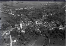
 View of Mettmenstetten from Paradis |
|
| Location of the municipality | |
  |
|
Mettmenstetten ( Swiss German : Mättmischtette or Mättmi , in the local dialect pronunciation Mäpmischtette or Mäpmi ) is a municipality in the district of Affoltern of the Canton of Zurich in Switzerland . The political community was formed in 1895 from the civil parishes of Ober- and Untermettmenstetten and the hamlets of Rossau , Dachlissen and Herferswil .

geography
Mettmenstetten is located in the southwest of the canton of Zurich and, with 13.11 km², is the second largest municipality in the Affoltern district after Hausen am Albis but ahead of Stallikon and Affoltern am Albis . The village of Mettmenstetten is 17 kilometers from Zurich and 12 kilometers from Zug . The hamlets of Dachlissen, Eigi, Grossholz, Herferswil, Hübscheren, Rossau and Wissenbach belong to the community. The largest part of the municipal area is taken up by agricultural land, which comprises 67.9 percent. Another 19 percent are forest, 7.8 percent settlement area and 5.3 percent traffic area.
In the north is the district capital Affoltern am Albis . The communities of Aeugst am Albis are located higher up towards the Albis in the northeast and Rifferswil and Kappel am Albis in the east . To the south lies Knonau , west Maschwanden and Obfelden .
geology
In geological terms, Mettmenstetten is located in the Molasse basin of the Swiss plateau . In the course of the Tertiary , the basin was filled with debris from the emerging Alps , whereby the sediments can be divided into different layers. Deposits under marine conditions are referred to as sea molasses, those under fluvial conditions as fresh water molasses . The community lies west of the Albis mountain range in a moraine landscape that opens up towards the Reuss plain .
Affoltern and the region received the decisive influence on the landscape from the advance of the Reuss Glacier during the various ice ages . The glacier deepened and widened existing valleys and created new valleys.
climate
Mettmenstetten is located in the temperate climate zone . The climate is shaped on the one hand by the winds from western directions, which often bring precipitation , and on the other hand by the bise (east or north-east wind), which is usually associated with high pressure, but brings cooler weather phases in all seasons than would be expected on average. The foehn , which is important in the Alpine valleys and on the edge of the Alps , does not normally show any special climatic effects on Mettmenstetten. The closest MeteoSwiss climate measuring stations are in Lucerne and Zurich-Affoltern , 13 and 27 kilometers away, respectively. Both stations deliver approximately the same values. This results in an average annual temperature of 8.7 ° C for Mettmenstetten. The coldest month is January with -0.4 ° C, the warmest is July with 21.0 ° C. The amount of precipitation is around 1100 mm per year, with higher amounts being measured in the three summer months than in winter due to the convective precipitation .
Flora and fauna
The flora of Mettmenstetten and the surrounding communities comprises around 1,100 plant species; without algae, fungi, lichen and moss. Deciduous forests, especially the woodruff beech forest, are widespread in Affoltern . On soils that are more humid due to the higher clay content or their location at the foot of the slope or at the edges of the hollow, the beech is increasingly being displaced by sycamore and ash . Wild garlic corridors determine their undergrowth. The Turkish League is widespread in all lime-rich mixed deciduous forests . The region is home to the typical animal species of the north-west Swiss plateau, such as the buzzard and kestrel , barn owl , gray heron , fox , badger , grass snake as well as the rare natterjack toad and common frog . The common redstart and the cuckoo , for example, have disappeared . The red kite is the largest bird of prey in the region.
history
During the Roman era, the region was sparsely populated and manors dominated the landscape. The remains of a Roman estate can still be found in Niederfeld today, well preserved in the ground. The church of Mettmenstetten is mentioned for the first time in 998 in a document from the Pfäfers monastery . The first documented mention of the village of Metemunstat dates back to 1116. Rossau is mentioned for the first time in 1221.
The first coat of arms for Mettmenstetten is mentioned in 1285 and shows an anchor cross. The ownership of the Vogtei Knonau with Ober-Mettmenstetten changes in 1309 from the Lords of Eschenbach-Schnabelburg to the Knights of Hünenberg, who introduce the coat of arms with the double unicorn, which is still valid today. Vogt Hartmann receives Vogt power over Mettmenstetten. In 1398 Mettmenstetten became the plaything of a hectic land swap. First, the Knights of Seon take over. Then ownership is transferred to the Lords of Heidegg and, last but not least, the nobles of Landenberg Mettmenstetten call them their own. The Mayor of Zurich, Johannes Meyer von Knonau, acquired the “Meyerhof” near the Linde in Ober-Mettmenstetten in 1399: court was also held there. The Wiesenbach Bridge, which is still in use today, was built in 1490 on the Zurich - Lucerne trade route. The church was expanded from 1510 to 1521 and gradually took on its current form. The people of Zurich lose their lives in the battle of Kappel and the reformer Zwingli in 1531.

The construction activities for living space were drastically restricted in 1607, construction freeze. Extension is partly allowed, so the "row houses" that still exist today are built.
Many Mettmenstetter emigrate to America at the beginning of the 18th century. A ban on emigration is issued, which is given little attention due to the great need. In 1803 five parliamentary groups (Unter-, Obermettmenstetten, Dachlissen, Rossau and Herferswil ) were merged into one civil parish. Mettmenstetten now belongs to the Horgen district. In Mettmenstetten, the first rural district school in Zurich was founded in 1826 (later called the secondary school). Mettmenstetten was assigned to the Affoltern district in 1837 and lost its status as district capital. Affoltern is the capital from now on. In 1895 Ober- and Unter-Mettmenstetten were combined. The first Catholic church was in Mettmenstetten on the Rütteli. Mettmenstetten received an S-Bahn connection in 1990 . Popular initiative to prevent the highway through the Säuliamt is rejected by the people. In 2009, the A4 motorway section was opened through the Knonaueramt as an important link between Lucerne and Zurich. Traffic is shifting more and more to the motorway. Mettmenstetten celebrated its 900 year anniversary in 2016.
Surname

The first evidence of names is Metmenstetten (998, linguistically adapted copy from the 17th century), Metemunstat (1116) and Metmonstetten (1173). In local historical publications you can read that the place name could have been the court of an Alemannic settler named Metamon or Metemun. However, there is no medieval evidence for such a personal name. Current research on place names assumes that the name Mettmenstetten is based on the Old High German adjective metamo (middle, middle) and the noun stat (place, place, place; plural: sta ). In Old High German the settlement would have been called Metamastat (middle place), Metamunsteti (middle place) or ze den Metamonstetin (with middle place / settlements).
It can only be speculated between which two places Mettmenstetten was founded: The middle of three Alemannic farms, in the middle between Zurich and Lucerne, between the hamlets of Rossau and Dachlissen, between the villages of Kappel am Albis and Maschwanden? Or was it the central position between the settlements Unterlunnern and Baar, which existed in Roman times ?
coat of arms
- In silver, two black unicorn hulls that have grown together and turned away.
It was first mentioned in 1285, when Mettmenstetten was still largely under the rule of the Barons of Eschenbach , whose emblem - an anchor cross on a yellow background - was adopted by the later Freiamt and today's Affoltern district . After the downfall of the Eschenbacher, the nobles von Hünenberg received their ownership rights in all of Mettmenstetten in 1309 . They introduced the unicorn heads in their coat of arms . When this knight family disappeared, their emblem remained as the Mettmenstetter coat of arms. The oldest evidence for the coat of arms of the municipality or the parish are the unicorn hulls in the middle of the wooden ceiling, which the Zug carpenter Jakob Winkler carved for the Mettmenstetten church in 1521.
Mättmi900 - Anniversary logo 900 years of Mettmenstetten:
A special anniversary logo was created for the 900 year anniversary (2016) of Mettmenstetten. The two black unicorn hulls are wrapped in a festive loop with the anniversary motto: "Mättmi fiiret 900 years"
population
| Population development | |
|---|---|
| year | Residents |
| 1836 | 1405 |
| 1850 | 1450 |
| 1900 | 1396 |
| 1950 | 1710 |
| 2000 | 3724 |
| 2008 | 4109 |
| 2012 | 4414 |
4,414 people live in Mettmenstetten (as of the end of 2012). 13.5 percent of the residents registered in Mettmenstetten, that is 594 people, do not have a Swiss passport. In 2012, 16.4 percent of the population were younger than 15 years and 6.3 percent of the population were between 15 and 19 years of age. Around 62.9 percent of the population are between 20 and 64 years of age. 14.3 percent of the population were older than 64 years.
The official and lingua franca of German, which is spoken predominantly as Zurich German in everyday life .
Today the Evangelical Reformed is the largest religious group with 53.1 percent, followed by the Roman Catholic Church with 27.8 percent. More and more people in Mettmenstetten describe themselves as non-denominational; the proportion of those with no religious affiliation (11.3 percent) and those without a denomination (3.2 percent) was 14.5 percent in 2000.
In October 2012, 57 people in Mettmenstetten were registered as unemployed according to the statistical office of the canton of Zurich. This corresponds to an unemployment rate of 1.9 percent. The proportion of women in Mettmenstetten in 2012 was 49.5 percent.
traffic
By the municipality Mettmenstetten the 1864 by leading Zurich-train-Lucerne railway opened railway line Zurich-train ; it is served by the S 5 Zug - Affoltern a. A. - Zurich HB - Uster - Pfäffikon SZ served by the Zurich S-Bahn .
Two postbus lines operate from Mettmenstetten, train station:
230 Mettmenstetten - Uttenberg - Maschwanden
232 Mettmenstetten - Rossau - Uerzlikon - Hauptikon - Rifferswil - Mettmenstetten (circular route)
The Postbus line also runs through Mettmenstetten:
223 Affoltern aA - Mettmenstetten, Rennweg - Rifferswil - Hausen am Albis
Attractions
There are four churches in Mettmenstetten:
- The reformed church is in the center of the village. As a special feature, it has a late Gothic wooden ceiling decorated with flat carvings, which was made by Jakob Winkler in 1521.
- The Catholic Church of St. Burkhard dates back to 1968 and was expanded to include a parish center in 2000. Its predecessor was a chapel from 1935.
- The Evangelical Anabaptist Congregation (ETG) is located at Weidstrasse 20.
- The New Apostolic Church was built on Langacherstrasse .
photos

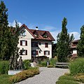
Old secondary school building and old secondary school building
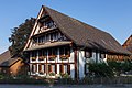
Former farmhouse from 1676
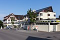
Gasthaus "zum weissen Rössli" and Volg
Sunday school students and foundling

St. Burkard Catholic Church

Reformed Church Mettmenstetten


Personalities
- Ernst Brunner (1901–1979), photographer
- Thomas Lambert (* 1984), freestyle skier
literature
- Hermann Fietz: The art monuments of the canton of Zurich, Volume I: The districts of Affoltern and Andelfingen. (= Swiss art monuments. Volume 7). Edited by the Society for Swiss Art History GSK. Bern 1938. DNB 365803030 .
Web links
- Official website of the municipality of Mettmenstetten
- Martin Illi: Mettmenstetten. In: Historical Lexicon of Switzerland .
- Link catalog on the subject of Mettmenstetten at curlie.org (formerly DMOZ )
Individual evidence
- ↑ Permanent and non-permanent resident population by year, canton, district, municipality, population type and gender (permanent resident population). In: bfs. admin.ch . Federal Statistical Office (FSO), August 31, 2019, accessed on December 22, 2019 .
- ↑ Data on the resident population by home, gender and age (community profile). Statistical Office of the Canton of Zurich, accessed on December 22, 2019 .
- ^ Heinz Gallmann: Zurich German Dictionary . Verlag Neue Zürcher Zeitung, Zurich 2009.
- ↑ Statistical data of the Mettmenstetten municipality
- ↑ Unless otherwise noted, the information refers to the Mettmenstetten village chronicle: history and stories, author Hans Huber-Hegglin, Verlag Gemeinde Mettmenstetten, 1992
- ↑ 900 year anniversary
- ↑ a b c Mettmenstetten Online: coat of arms / place name ( memento of the original from September 25, 2009 in the Internet Archive ) Info: The archive link was inserted automatically and has not yet been checked. Please check the original and archive link according to the instructions and then remove this notice.
- ↑ https://search.ortsnames.ch/de/record/802000009
- ^ Daniel Gut: Lunnern. London's twin in the Reuss Valley. A linguistic and cultural-historical location of settlement names. BoD, Norderstedt 2010, ISBN 978-3-8370-8758-1
- ↑ www.mättmi900.ch
- ↑ Community portraits / database - statistics . Website Canton of Zurich, Directorate of Justice and Home Affairs, Statistical Office. Retrieved October 21, 2013.
- ^ Website of the evangelical reformed parish of Mettmenstetten. Section wooden ceiling. Retrieved December 25, 2014.
Aeugst am Albis | Affoltern am Albis | Bonstetten | Hausen am Albis | Hedingen | Kappel am Albis | Knonau | Maschwanden | Mettmenstetten | Obfelden | Ottenbach | Rifferswil | Stallikon | Wettswil on the Albis
Canton of Zurich | Districts of the Canton of Zurich | Municipalities of the Canton of Zurich