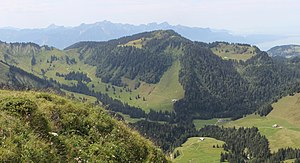
Le Molard
| Le Molard | ||
|---|---|---|
|
View from Col de Lys to the Molard, on the left the Col de Soladier , on the right Lake Geneva , in the background the massif around the Cornettes de Bise , in the foreground the valley of the Veveyse de Fégire |
||
| height | 1751 m above sea level M. | |
| location | Canton of Vaud , Switzerland | |
| Mountains | Freiburg Pre-Alps | |
| Dominance | 1.7 km → Vanil des Artses | |
| Notch height | 175 m ↓ Col de Soladier | |
| Coordinates | 563263 / 148 187 | |
|
|
||
| rock | Sedimentary rock | |
| Normal way | Mountain hiking | |
Le Molard (formerly Crêt du Mollard ) is 1751 m above sea level. M. high mountain of the Freiburg Pre-Alps on the border of the communities Blonay and Montreux in the Swiss canton of Vaud .
Surname
Molard comes from the Latin moles or molare for pile of earth, hill or hill.
location

The summit is between five valleys: the Ruisseau de Saudanne in the northwest and a flowing north on the map of Switzerland unnamed brook flowing after a few kilometers into the Veveyse de Fégire whose valley in eastern Molards located and a tributary of the Veveyse is . In the southwest lies the valley of the Avessan torrent, which flows into the Baye de Clarens after a few kilometers . In the southeast lies the valley of the Ruisseau de Malaz Chenau, which flows into the Baye de Montreux after a few kilometers . All of these rivers flow into Lake Geneva at Vevey , Clarens and Montreux .
Immediately to the east of the mountain rises the mountain range that leads from Moléson ( 2002 m above sea level ) and Dent de Lys ( 2014 m above sea level ) to Rochers de Naye ( 2042 m above sea level ) and through its distinctive Rock walls to the west are striking.
The Molard rises 175 meters saddle height above the Col de Soladier ( 1576 m above sea level. M. ) to the southeast, on the one on a demanding alpine hiking (T5) to Cape au Moine reach can. The Vanil des Artses to the north of it can only be reached by difficult alpine hiking (T6).
West of Mollard is the La Forcla pass ( 1622 m above sea level ), which rises to 1730 m above sea level. M. high Le Folly leads.
The mountain lies on the northern border of the Parc naturel régional Gruyère Pays-d'Enhaut , a park of national importance .
geology
The mountain consists of fossil leading calcite from the series of the Lower Jurassic .
Ascent
The ascent, classified as a mountain hike (T2) according to the SAC hiking scale, is possible from Villard-sur-Chamby , Les Avants , Les Pléiades or Les Paccots near Châtel-Saint-Denis .
In the Geographical Lexicon of Switzerland of 1905 it is described that the mountain was often visited by spa guests from Les Avants, Villars (today Villard-sur-Chamby), L'Alliaz and Montreux .
Web links
- Tours and photos of the Molard at hikr.org
Individual evidence
- ↑ a b c Le Molard on the national map of Switzerland .
- ^ A b c Charles Knapp, Maurice Borel, Victor Attinger, Heinrich Brunner, Société neuchâteloise de geographie (editor): Geographical Lexicon of Switzerland . Volume 3: Krailigen - Plentsch . Verlag Gebrüder Attinger, Neuenburg 1905, p. 393, keyword Mollard (Crêt du) ( scan of the lexicon page ).
- ↑ Freiburg Pre-Alps at geofinder.ch
- ^ Charles Knapp, Maurice Borel, Victor Attinger, Heinrich Brunner, Société neuchâteloise de geographie (editor): Geographical Lexicon of Switzerland . Volume 3: Krailigen - Plentsch . Verlag Gebrüder Attinger, Neuenburg 1905, p. 390, keyword Molard, Mollard ( scan of the lexicon page ).

