
Flem
| Flem | ||
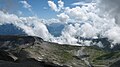
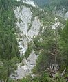
 Flem at Trin Mulin; in the background the Flimserstein |
||
| Data | ||
| Water code | CH : 303 | |
| location | Canton of Graubünden ; Switzerland | |
| River system | Rhine | |
| Drain over | Vorderrhein → Rhine → North Sea | |
| confluence | from two source streams in the area Il Vonn 46 ° 53 ′ 9 ″ N , 9 ° 13 ′ 0 ″ E |
|
| Source height | 2416 m above sea level M. | |
| muzzle | in the Vorderrhein coordinates: 46 ° 48 '44 " N , 9 ° 20' 45" E ; CH1903: 745 552 / 186 323 46 ° 48 '44 " N , 9 ° 20' 45" O |
|
| Mouth height | 608 m above sea level M. | |
| Height difference | 1808 m | |
| Bottom slope | 11% | |
| length | 16.3 km | |
| Catchment area | 82.34 km² | |
| Discharge at the estuary A Eo : 82.34 km² |
MQ Mq |
2.89 m³ / s 35.1 l / (s km²) |
| Left tributaries | Segnas Sura, Turnigla | |
| Right tributaries | Aua da Lag la Cresta | |
| Communities | Flims | |
The Flem ( ) is an approximately 16 kilometer long tributary of the Vorderrhein in the Surselva in the Swiss canton of Graubünden .
course
The water collects in the Il Vonn area between the Laaxer Stöckli in the southwest and the Ofen in the northwest. From the Upper Segnasboden Plaun Segnas Sura the glacier milk of the Segnas glacier falls in a waterfall . As Ual Segnas the brook flows via Stargels and Foppa in a south-easterly direction towards Flims , where the name changes.
Before Flims, the Flem flows through the Val Stenna with the Stennaschlucht. An old promenade led from the sawmill over several bridges to the "Känzeli", a rock with a view of the river. All of these bridges were removed during the construction of the Flims bypass. Old postcards from the turn of the century to around 1930 show the river in the Stenna Gorge and designate a fall there as the Segnes Waterfall and the gorge as the Segnes Gorge. After the gorge, the Flem divides the Flims-Dorf and Flims-Waldhaus parts.
The river flows east near Flims. After the settlement area, it continues to flow in the rubble of the Flims landslide near Marcau before it reaches the adjacent rock halfway to the Crestasee and forms the Felsbach gorge . Shortly before the Trin Mulin plain , it picks up the draining water of the Cresta Lake on the right, then turns south and is dammed by a small reservoir at the Pintrun power station . After the deeply cut ravine Val Pintrun , the confluence with the Vorderrhein is found in an uninhabited and previously inaccessible area.
New development "Trutg dil Flem"
In May 2011, the voters of the municipality of Flims narrowly agreed to the new connection trutg-dil-flem (Path of the Flem). To complement the network of hiking trails, a path has been created to follow the river from the lower Segnas floor to the nearby village. To this end, seven new bridges were built that were designed by Jürg Conzett . A book describes the path in pictures and words. Until April 2014 the museum in Flims, the Yellow House , showed an exhibition on the construction of the new bridges.
History gallery
Upper Segnesboden from Piz Dolf
Upper Segnesboden to Piz Dolf
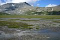
Lower Segnasboden

Lower Segnasboden with alluvial fans of the river from the Upper Segnasboden, behind it oven and Tschingelhörner

On the slide of the Flims rockslide near Punt Tarschlims

Stennaschlucht with the "Känzeli", the historical end of a walking path

Felsbachschlucht west of the Cresta lake

Pintrun power plant
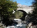
Punt da Trin at Pintrun on the course of the historic Digg-Conn-Sagogn connection

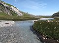
Val Pintrun towards Bargis, Flimserstein on the left, Tschep on the right on the horizon
The Flem in the last section “Val Pintrun” before reaching the Rhine in the Ruinaulta


literature
- Wilfried Dechau et al .: Trutg dil Flem Seven Bridges by Jürg Conzett . 2013, ISBN 978-3-85881-374-9 .
Web links
Individual evidence
- ↑ a b Geoserver of the Swiss Federal Administration ( information )
- ↑ Hydrological Atlas of Switzerland of the Federal Office for the Environment FOEN, Table_13
- ↑ a b Modeled mean annual discharge. In: Topographical catchment areas of Swiss waters: sub-catchment areas 2 km². Retrieved August 24, 2017 .
- ↑ Flims-Cassons