
Tschingelhorns
| Tschingelhorns | ||
|---|---|---|
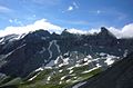
 Tschingelhörner taken from the east from point 2459. The Segnespass would then be on the right (covered). |
||
| height | 2849 m above sea level M. | |
| location | Border canton Glarus / Canton Graubünden , Switzerland | |
| Mountains | Glarus Alps | |
| Dominance | 0.83 km → furnace | |
| Coordinates | 736 008 / 195559 | |
|
||
| rock | Verrucano structure on limestone | |
| Age of the rock | Permian and Jurassic | |
| particularities | In the Bernese Oberland there are also various elevations with the name Tschingel. | |
 left oven and then Tschingelhörner seen from the lower Segnasboden. On the right is the gap of the Segnespass. |
||

The Tschingelhörner are a chain of mountain peaks in Switzerland . The summit structure consists - like that of the neighboring Ofen and Piz Segnas - of the Permian rocks of the Verrucano ceiling, which was visibly pushed over late Jurassic quinten limestone when the Alps were folded . The latter forms the base of the mountain.
Surroundings
The peaks are located south of the Segnespass , which connects Elm in the canton of Glarus with Flims in the canton of Graubünden . Nine peaks can be counted between the kiln 2873 m and the Segnespass 2625 m, the last of which stands alone on the base and has no connection through Verrucano rock to the rest above the Martinsloch . On the national map 1: 25,000 heights can only be found for 4 peaks: the higher peak at the Segnespass at 2743 meters, the great Tschingelhorn at 2849 meters, then the prominent second southernmost peak at 2843 meters and the southernmost one at the Ofen Leaning with 2817 meters.
While Verrucano often appears as red rock in the canton of Glarus, the Verrucano here is green and slate.
rise
Access is from Elm or Flims. From Elm the chairlift can be used to Nideren, from Flims the chairlift to Naraus. A mountain path leads via the Camona da Segnas ( 2102 m ) further using the Kar the lower Bless bottom up towards Segnespass. The Tschingelhörner are reserved for climbers and are prone to falling rocks. In recent years, the Swiss National Day an bonfires on the big Tschingelhorn 2849m inflamed, which is visible from Flims Waldhaus from.
Martinsloch
The Martinsloch is located to the north under the great Tschingelhorn . The approach was signposted as closed from 2008 to 2010 for safety reasons (rockfall). Among other things, relatively newly installed chains, which were used for safety, were demolished by falling rocks.
The stove and Tschingelhörner with Martinsloch from the east, Flims side

Web links
Individual evidence
- ^ O. Adrian Pfiffner: Geologie der Alpen , Verlag Haupt, Bern 2009, ISBN 978-3-8252-8416-9 , page 176.
- ↑ National map 1: 25,000 Elm, number 1174.