
Falconies
| Falconies | ||
|---|---|---|
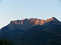
 View from the southwest |
||
| height | 2560.4 m above sea level M. | |
| location | Graubünden , Switzerland / Liechtenstein border | |
| Mountains | Rätikon | |
| Dominance | 1.3 km → Vordergrauspitz | |
| Notch height | 40 m | |
| Coordinates | 761 468 / 213 228 | |
|
||
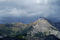
 Summit cross |
||

The Falknis is a mountain above the Rhine Valley in the Swiss canton of Graubünden and in the Principality of Liechtenstein and the westernmost peak of the Rätikon chain .
location
The summit lies on the border between Liechtenstein and Switzerland between the Bündner municipality of Fläsch and the Liechtenstein municipality of Triesen . It is accessible by a hiking trail and is located at 2560 m above sea level. M.
The view from the Falknis extends to the north as far as Lake Constance .
Surname
The name Falknis is said to be derived from the Latin falcula f. 'Kleine Sichel' or accordingly old Rhaeto-Romanic falcla s 'kleine Sicheln ' originate, from which after the language change Alemannic through consonant dissimilation and vowel elevation in the auxiliary syllable Falknis . The name originally referred to today's falconry tower far below the summit.
Ascent
There are different ways to go up:
- from Seewis in the Prättigau through the Canitobel over the Maienfeld Alps and the Fläscher Alp Sarina and further through the Fläschertal , also called Radaufis , running southeast of the mountain peak to the Fläscher Fürggli and from there to the summit
- from Malans with the Älplibahn to the Älpli and across the Jenins Alps to Sarina, from there continue as described
- from Jenins across the Jenins Alps and further as described
- from St. Luzisteig through the Gleggtobel to Fläscher Fürggli and further as described
- from St. Luzisteig to the Enderlinhütte of the Swiss Alpine Club and on to the Fläscher Fürggli - the direct and very steep ascent
- from St. Luzisteig via the former Walser settlement Guscha and the Guschagrat to the Falknishorn and on to the summit - the most exposed route
- from Triesen past the Teufelstein, then with an imposing view down into the Lawenatobel, where the legendary figures, the so-called " Tobelhocker ", sit at the stone table towards Alp Lawena , then on the ridge at the Falknishorn, through the Falknissüdwand up to the summit - very long climb, around six hours with an altitude difference of almost 2000 meters
Adjacent peaks
Neighboring peaks are the Glegghorn and Vilan in the southeast , Grauspitz and Naafkopf in the east, and the Fläscherberg with the Regitzer Spitz and the Falknishorn in the west . To the west of it the Chur Rhine Valley and the St. Gallen Rhine Valley .
Maps
- National map of Switzerland 1: 25,000, sheets 1155 and 1156
photos
from the south from the Landquart area
in spring from the west

at dusk

The falcon stands above the Maienfeld vineyards
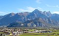
Falknis behind the Fläscherberg


source
- Manfred Hunziker: Ringelspitz / Arosa / Rätikon , Alpine Touren / Bündner Alpen , Verlag des SAC 2010, ISBN 978-3-85902-313-0 , p. 463.
Web links
Individual evidence
- ^ Stricker, Hans / Banzer, Toni / Hilbe, Herbert: The place and field names of the Principality of Liechtenstein . Vaduz: Historical Association for the Principality of Liechtenstein, Volume 5: 152; http://namesbuch.gmg.biz/