
Naafkopf
| Naafkopf (Schneetälispitz) | ||
|---|---|---|
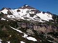
 Naafkopf, seen from Alp Gritsch (Liechtenstein) |
||
| height |
2571 m above sea level A. 2570 m above sea level M. |
|
| location | Vorarlberg , Austria / Graubünden , Switzerland / Schaan municipality , Liechtenstein | |
| Mountains | Rätikon | |
| Dominance | 1.62 km → Schwarzhorn | |
| Notch height | 223 m ↓ Ijesfürggli | |
| Coordinates , ( CH ) | 47 ° 3 '39 " N , 9 ° 36' 26" O ( 764 728 / 214477 ) | |
|
||
| rock | Breccias from the Upper Jurassic with volcanic debris made of granite and quartz porphyry , as well as limestone | |
| First ascent | No information has been handed down | |
| Normal way | from the north ( Pfälzerhütte ) over the north ridge | |
| particularities | The tri-border region between Austria, Liechtenstein and Switzerland | |

The Naafkopf , also called Schneetälispitz , with an altitude of 2,571 meters above the Adriatic (Austrian leveling ) and 2,570 meters above sea level (Swiss leveling) a climbing - and hiking mountain in the Rätikon , a mountain range in the Western Central Alps .
The survey point of the summit with a cross is exactly on the state border between the Austrian state of Vorarlberg , the Swiss canton of Graubünden and the southernmost area of the Liechtenstein municipality of Schaan . So it lies on a triangle . To the north, southeast and northwest it sends pronounced ridges of carrying the state borders: to Älpelekopf between Samina - and Gamperdonatal , for Schesaplana , with the Aebi the Grüscher Taschinesbachtals , and Falknis .
The Naafkopf looks like a flat pyramid from the east , but is very rugged when viewed from the other directions. This and its easy accessibility make it a popular destination for both climbers and hikers.
Surroundings
The Naafkopf belongs to the Naafkopf-Falknis chain and represents its eastern end point. The Vorarlberg village of Nenzinger Himmel is about four and a half kilometers to the northeast as the crow flies . Graubündner Jenins is a good seven and a half kilometers away, in a south-southwest direction . The next Liechtenstein town is Malbun, around five kilometers to the north . South of the Naafkopf there is a basin with the Alpe Ijes, about 1.5 km in diameter . The Naaftal , which is open to the north, extends to the north , and the western flank falls down to the plateau -like Barthümelalpe with its red wall . Neighboring mountains of the Naafkopf are in the course of the north ridge , separated by the Bettlerjoch crossing at an altitude of 2,108 meters, the 2,365 meters high Augstenberg , in the course of the southwest ridge , separated by the Barthümeljoch (2,305 m), the Tschingel is located at an altitude of 2,541 meters and in the southwest , separated by the Ijesfürggli , the 2,574 meter high Hinter Grauspitz , also called the Schwarzhorn .
Bases and paths
The Naafkopf is accessible through a well-developed network of trails. The Liechtensteiner Weg , which is partially equipped with rope insurance and connects the Pfälzerhütte on the Bettlerjoch and the Salarueljoch in the east, leads through its northwest flank at an altitude of around 2,200 meters .
The Pfälzerhütte of the Liechtenstein Alpine Club serves as a base for ascent of the Naafkopf on the normal route . It takes one hour to walk from the hut to the summit without difficulty. From Alpe Ijes the south, the walking time is according to the literature about 2½ hours of UIAA difficulty I . Serious climbing trips, on the other hand, lead over the west ridge, which has been climbed since 1924, in UIAA grade II to IV in free climbing ( technical : A0 ).
Literature and map
- Manfred Hunziker: Ringelspitz / Arosa / Rätikon , Alpineouren / Bündner Alpen , Verlag des SAC 2010, ISBN 978-3-85902-313-0 , p. 475
- Günther Flaig: Alpine Club Guide Rätikon , Bergverlag Rudolf Munich, 1989, ISBN 3-7633-1098-3
- Alexander Tollmann : Geology of Austria, Volume I - The Central Alps , Vienna, F. Deuticke, 1977
- National map of Switzerland 1: 25,000, sheet 1156, Schesaplana
Web links
gallery

The Naafkopf seen from the Pfälzerhütte
The Naafkopf from the east

On the summit of the Naafkopf


