Palatinate Hut
| Pfälzerhütte LAV hut category I |
||
|---|---|---|
|
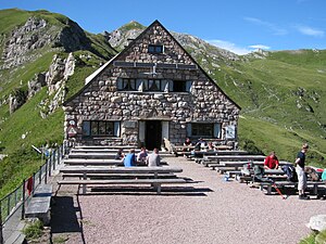
The Pfälzerhütte in August 2010 |
||
| location | Beggar's yoke ; Liechtenstein ; Valley location: Triesenberg | |
| Mountain range | Rätikon | |
| Geographical location: | 765 159 / 215 663 | |
| Altitude | 2108 m above sea level M. | |
|
|
||
| owner | Liechtenstein Alpine Club | |
| Construction type | hut | |
| Usual opening times | Mid June to mid October | |
| accommodation | 11 beds, 51 camps , 20 emergency camps | |
| Winter room | 4 bearings | |
| Web link | Palatinate Hut | |
| Hut directory | ÖAV DAV | |
The Pfälzerhütte is a refuge of the Liechtenstein Alpine Association (LAV). It is located on the Bettlerjoch at 2108 m in the Rätikon in Liechtenstein , right on the Austrian border.
history
In 1925, the association of the Palatinate Sections in the German and Austrian Alpine Association was granted permission to build a managed hut on the Bettlerjoch. From the architecture competition held in autumn 1926 and 37 drafts received, that of Ernst Sommerlad was selected. The construction time was 113 days and the construction cost 93,000 francs . The hut was opened on August 5, 1928. The first couple of hosts was Ida and Hermann Ospelt from Vaduz, who ran the hut for eleven years. The hut was looted and damaged several times during the Second World War .
After the end of the Second World War, Switzerland became the owner of the hut and in 1950 it became the property of the Liechtenstein Alpine Club, which paid 8,400 francs for it (including inventory). In 1952 the purchase became legally binding after Germany waived all claims for foreign sales that had been made up to that point. In 1964 the right to use the hut was regulated between the Palatinate and the Liechtenstein Alpine Association, who were now allowed to use the hut equally.
building
The original, two-story building consists of massive quarry stone masonry. It is a simple structure with a floor plan of around 10 × 13 meters. The terrace extending from the basement is south-facing.
Management
The hut is open from around mid-June to around mid-October; the dining room offers 60 seats. There are also eleven beds, 51 camps and a further 20 emergency camps in the adjoining building, as well as a group room for 20-25 people. The winter room in the annex is accessible without a key and offers space for four people.
Accesses
- From Malbun ( 1600 m ) via Fürstin-Gina-Weg , walking time: 1.5 hours
- From Nenzing ( 530 m ) over Nenzinger Himmel , walking time: 5 hours
- From Nenzinger Himmel ( 1358 m ) 2.5 hours
- From Steg ( 1300 m ) via Alp Valüna and Alp Gritsch , walking time: 2.5 hours
- Via the Via Alpina stage R58
Tour possibilities
Transitions to other huts
- To the Mannheimer Hütte ( 2679 m ) via Liechtensteinerweg , walking time: 4.5 hours
- To the Schesaplanahütte ( 1908 m ), walking time: 3.5 hours
- To the Enderlinhütte
- To the Silum mountain inn , walking time: 4 hours
Mountaineering
- On the Naafkopf ( 2571 m ), walking time: 1 hour 15 minutes
- Up the Augstenberg ( 2359 m ), walking time: 45 minutes
Trivia
The Pfälzerhütte is the motif of the joint stamp issue with the same motif, which Germany and the Principality of Liechtenstein jointly issued on June 14, 2012.
literature
- Manfred Hunziker: Ringelspitz / Arosa / Rätikon , Alpine Tours / Bündner Alps . Verlag des SAC , 2010, ISBN 978-3-85902-313-0 , p. 487
Web links
- A great honor for the Palatinate Hut
- Pfälzerhütte on the website of the Liechtenstein Alpine Club
- Pfälzerhütte on GeoFinder.ch
- Cornelia Herrmann: Palatinate Hut. In: Historical Lexicon of the Principality of Liechtenstein .
Individual evidence
- ^ Hermann Ospelt later became a national geometer in Liechtenstein.
- ↑ Panorama - The Liechtensteiner Alpenmagazin , November 2018, p. 36.
- ↑ Panorama - The Liechtensteiner Alpenmagazin, November 2018, p. 37.
- ↑ Christoph Maria Merki : Liechtenstein Economic Miracle: the rapid modernization of a small economy in the 20th century . Publishing house of the Historical Association for the Principality of Liechtenstein, 2007, ISBN 978-3-906393-42-1 , p. 265 ( Google Books ).
- ^ Foundation Sommerlad , website of the foundation.
- ↑ Special stamps June 2012. Federal Ministry of Finance; Retrieved June 18, 2012
- ^ German-Liechtenstein reconciliation . In: NZZ , June 18, 2012; Retrieved June 18, 2012


