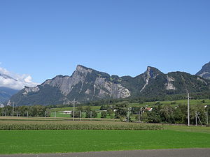
Regitzer Spitz
| Regitzer Spitz | ||
|---|---|---|
|
Regitzer Spitz left of center |
||
| height | 1135 m above sea level M. | |
| location | Switzerland | |
| Mountains | Rätikon | |
| Dominance | 2.25 km → Windegg | |
| Notch height | 422 m ↓ St. Luzisteig | |
| Coordinates | 757 150 / 211 633 | |
|
|
||
| Type | Main summit | |
| rock | limestone | |
The Regitzer Spitz is 1135 m above sea level. M. the main summit of the Fläscherberg in the Swiss canton of Graubünden . It is the westernmost branch of the Rätikon .
location
The mountain is in the area of the municipality of Fläsch , the village is slightly south between Regitzer Spitz and the Rhine in the west. The northern foot of the Fläscherberg forms the state and national border with the Principality of Liechtenstein. Its national territory does not extend anywhere higher than 660 meters on the Fläscherberg, that is only 200 meters above the valley floor near Balzers .
Only the most north-westerly spur, the Ellhorn ( 758 m above sea level ) opposite Sargans , is characteristic of the landscape. Here the Rhine comes directly to the foot of the western rock faces of the Fläscherberg, which makes the right bank of the Rhine at the state border impassable for vehicles. At Fläsch the bank of the Rhine opens up again and forms the floodplain Rhine sand .
To the east, the Fläscherberg is separated from the higher mountains of the Falknis ridge by the pass crossing of the Luziensteig at 713 meters . The second distinctive peak of the Fläscherberg is the Guschaspitz ( 1102 m above sea level ).
Regitzer Spitz in front of the towering Falknis
National geographic importance
In the canton of Graubünden, the Fläscherberg is the northernmost mountain that lies entirely within the canton.
Its location above the Rhine valley - and also its shape - predestined the Fläscherberg to a bulwark of the Swiss army. You can occasionally see crew quarters and entrances to command bunkers in the upper part and to gun bunkers in the lower part.
Development
The east side of the Fläscherberg is gently rising and makes the summit of the Regitzer Spitz a popular destination for both hikers and mountain bikers. A steep path leads directly to Fläsch and other paths enable a circular hike. The hiking trail was closed from autumn 2013 to summer 2014 due to a rock fall, and since then it has been safely accessible again with a new route.
Rockslide
On November 25, 2012, 500 tons of rock loosened for the first time in the area of Tschingel Fortress and thundered down into the valley. A second rock fall occurred on October 15, 2013 in the Schnielskopf area. Between 50 and 100 cubic meters of rock fell down and were stopped by the forest. The rock fall cut a swath of about 80 meters and knocked down numerous trees. Nobody got hurt.
Regitzer Challenge
In 2014, 2015, 2016 and 2019 the running group Grischuni-Runners organized the "Regitzer-Challenge". The aim was to climb the Regitzer Spitz as often as possible during the year by hiking, running, walking and biking ("COUNT" category). There was also a time trial (category "TIME"). The Regitzer Challenge will be held again in 2020.
Web links
- Florian Hitz: Fläscherberg. In: Historical Lexicon of the Principality of Liechtenstein .
literature
- Manfred Hunziker: Ringelspitz / Arosa / Rätikon , Alpine Touren / Bündner Alpen , Verlag des SAC 2010, ISBN 978-3-85902-313-0 , p. 458
Individual evidence
- ↑ http://www.suedostschweiz.ch/vermischtes/felssturz-ueber-flaesch-keine-verletzt
- ↑ http://www.vilan24.ch/Flaesch.114.0.html?&cHash=0a607912512d9efae1fe768fb2a36494&tx_ttnews%5Btt_news%5D=7719
- ↑ http://www.suedostschweiz.ch/vermischtes/felssturz-ueber-flaesch-keine-verletzt
- ↑ Rigitzer Challenge on grischuni-runners.ch


