Carmenna
| Carmenna | |||
|---|---|---|---|
|
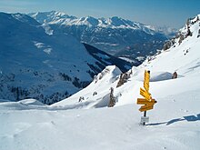
The Carmenna with plate horn |
|||
| Compass direction | east | northwest | |
| Pass height | 2368 m above sea level M. | ||
| Canton | Graubünden , Switzerland | ||
| Valley locations | Arosa | Tschiertschen | |
| expansion | trail | ||
| Mountains | Plessur Alps | ||
| map | |||
|
|
|||
| Coordinates | 767 574 / 183695 | ||
The Carmenna (also: Carmennapass, incorrect spelling: Carmänna) is an alpine pass in the Swiss canton of Graubünden . With a peak height of 2368 m above sea level. M. connects them via the Obersäss and the Urdental Innerarosa with Tschiertschen in Schanfigg .
description
A marked hiking trail, which is often used in summer, leads across Carmenna, which is located exactly between Weisshorn and Plattenhorn . This usually also serves as a southern ascent or descent route to the Weisshorn and, in conjunction with the Churer Alpweg (see below) at the northern foot of this mountain, offers a popular Arosa-Tschiertschen-Arosa round trip.
The Swiss Irontrail , which was first held in July 2012 , has been leading from Urdenfürggli - Hörnlihütte via Carmenna- Weisshorn to Arosa and from there via Medergen - Sapün - Strelapass to Davos .
Origin of name and history
The Carmenna ("adjacent alpine meadows" or possibly "roof ridge") has been the fastest connection to Chur for centuries for the Walsers, who have mainly settled in Innerarosa since the beginning of the 14th century . Compared to the much more comfortable route via Sattel-Ochsenalp-Tschiertschen (Churer Alpweg), this route was usually chosen when there was a great hurry or by travelers with little luggage. The route west of the pass at around 2330 m above sea level still testifies to the difficulty of this route . M. located, legendary " Gottlobstei ".
Carmennahütte
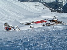
The Carmenna was, among other things, namesake of the one on the Chur Obersäss at 2134 m above sea level. M. located Carmennahütte . In summer it is an alpine restaurant and in winter it has been one of the largest and most famous ski huts in Switzerland since the 1920s . In addition to the decades of the Carmennachilbi and various sports and entertainment events - for example, bungee jumping from a 60 meter high crane in 1991/92 - the hut was often the location of large snow sculptures, such as dream castles, various animal motifs or a model of the Langwieser Viaduct . The legend of the Carmenna cowboy is at home at the Carmennahütte .
Ski lifts and chairlifts
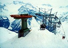
In 1938 the AG Autobus- und Skiliftanlagen (today: Arosa Bergbahnen ) opened up the area at the Carmenna with a first ski lift . The Carmennalift was built , which led from the Innerarosa ice rink to the "Untera Tüütschböda" area. This T-bar lift overcame a height of 321 meters over a length of 1256 meters. The "An der Alp" -Plattenhorn ski lift followed in 1966. In 2000 the Carmennalift - and with it the Obersäss chairlifts (demolished in 1999) and Boordried-Bänkli (demolished in 2002) that were built in this area in 1978 - was replaced after 62 years of operation by a detachable four-seater chairlift (popularly known as "Ferrari"), which now leads from the Bergkirchli in Innerarosa to the southwestern Weisshorn shoulder above the Carmenna. An intermediate exit was implemented at the former terminus of the ski lift. The Plattenhorn lift was replaced in 2002 by a four-seater chairlift.
swell
- Manfred Hunziker: Ringelspitz / Arosa / Rätikon , Alpine Touren / Bündner Alpen , Verlag des SAC 2010, ISBN 978-3-85902-313-0 , pp. 282, 298.
- Hans Danuser : Arosa - as it was then (1979-1995) , vol. 6, self-published by Danuser, Arosa 2002, p. 133.
- Hans Danuser: Arosa - as it was then (1907-1928) , vol. 2, self-published by Danuser, Arosa 1998, p. 171.
- SAC Clubführer, Bündner Alpen 1, Tamina and Plessur Mountains , Verlag des SAC, 4th edition 1988, p. 340 f.
- Fritz Maron: From mountain farming village to world health resort Arosa , Verlag F. Schuler, Chur 1934, p. 99.
Individual evidence
- ↑ Andrea Schorta: How the mountain got its name , Terra Grischuna Verlag, 3rd edition, Chur 1999, p. 73.
- ↑ Hans Danuser : Arosa - as it was back then (1979–1995). Vol. 6. Self-published by Danuser, Arosa 2002, p. 185 f.
- ↑ Photo Carmennalift (around 1940) at www.seilbahn-nostalgie.ch


