
La Dole
| La Dole | ||
|---|---|---|
 The mountain top of La Dôle |
||
| height | 1677 m above sea level M. | |
| location | Canton of Vaud , Switzerland | |
| Mountains | law | |
| Dominance | 13.93 km → Colomby de Gex | |
| Notch height | 357 m ↓ Col de la Faucille | |
| Coordinates | 497097 / 142400 | |
|
||

La Dôle is a mountain peak in the Vaud Jura in western Switzerland, ten kilometers west-northwest of Nyon . It reaches a height of 1677 m above sea level. M. and is therefore the second highest mountain in the Swiss Jura after the Mont Tendre, which is only two meters higher . The hilltop of La Barillette to the east is 1528 m high, the northeastern sub-peak Pointe de Poele Chaud (1628 m) is about 1.5 km away.
location
The mountain ridge of La Dôle is part of the southeastern chain of the Folded Jura , which is closest to the Swiss plateau . It is bounded in the southwest by the Col de la Faucille , in the northwest by the rearmost part of the Valserine valley, which flows into the Rhone at Bellegarde-sur-Valserine , in the north by the Col de la Givrine and in the southeast by the plain of the Mittelland. The border between Switzerland and France runs in the south and west near the Dôle mountain peak.
The approximately 1000 m high southeast slope of the Dôle is densely forested. The tree line is at around 1500 m , above which there are mountain pastures. In the area of the summit ridge you will find sinkholes and cart fields , the typical landscape forms for limestone mountains. The Valserine rises on the northern slope of the Dôle .
On the northwest slope of the Dôle, skiing is practiced in winter, there are several ski lifts there.
Radar station
A measuring station of the Federal Office for Meteorology and Climatology (MeteoSwiss) is located on the mountain , including a radar station that records the intensity of precipitation over the entire western part of Switzerland. The Swiss air traffic control system Skyguide also operates an air traffic control radar on the summit. There is also a Swisscom radio and television station on the Dôle , which broadcasts SRG SSR Idée Suisse programs to the Lake Geneva basin.
Accommodation was created for the employees in 1991, which were prefabricated from six elements similar to a fuselage and brought to the location by helicopter. They complement the ensemble of weather station and radome, between which they stand, and are adapted to the often almost polar weather with wind peaks of up to 200 km / h. The tubular aluminum-clad building was planned by Vincent Mangeat .
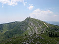
La Dôle with radar from the Pointe de Poêle Chaud

La Dole right in the background from the Lac des Rousses from

Radar systems
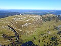
La Dôle, aerial view


Climate table
| La Dole, 1981-2010 | ||||||||||||||||||||||||||||||||||||||||||||||||
|---|---|---|---|---|---|---|---|---|---|---|---|---|---|---|---|---|---|---|---|---|---|---|---|---|---|---|---|---|---|---|---|---|---|---|---|---|---|---|---|---|---|---|---|---|---|---|---|---|
| Climate diagram | ||||||||||||||||||||||||||||||||||||||||||||||||
| ||||||||||||||||||||||||||||||||||||||||||||||||
|
Average monthly temperatures and rainfall for La Dôle, 1981-2010
Source:
|
||||||||||||||||||||||||||||||||||||||||||||||||||||||||||||||||||||||||||||||||||||||||||||||||||||||||||||||||||||||||||||||||||||||||||||||||||||||||||||||||||||||||||||||||||||
Web links
Individual evidence
- ↑ Dictionary of Skyguide AG
- ^ Out of thin air: Accommodation for civil air surveillance personnel . In: Werk, Bauen + Wohnen, Vol. 80 (1993) issue 3, pp. 64–67
- ↑ Climate table. In: meteoschweiz.admin.ch. meteoschweiz, accessed on December 13, 2018 .