St. Peters Island
| St. Peters Island | ||
|---|---|---|
| Heideweg and St. Petersinsel, looking north | ||
| Waters | Lake Biel | |
| Geographical location | 577 507 / 213356 | |
|
|
||
| length | 4.7 km | |
| width | 750 m | |
| surface | 1.76 km² | |
| Highest elevation | (the) Riedmatt 474 m |
|
| Residents | 5 (1983) 2.8 inhabitants / km² |
|
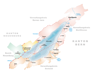
| Map of Lake Biel with St. Petersinsel | ||
The St. Peter's Island (French. Ile Saint-Pierre ) is (besides the partly flooded Bird Island ) is the only island of Lake Biel in the Bernese Seeland in Switzerland . It is located in the southwest of the lake near Erlach , has been connected to the mainland by a flat headland since the second half of the 19th century and is therefore actually a peninsula . However, an artificially created puncture at the port of Erlach that can be passed by boats separates this headland from the mainland.
The island is owned by the civic community of Bern and politically belongs to the Twann-Tüscherz community . The border to Erlach runs on the later created headland, where there is a boundary stone on the Heideweg.
geography
With a length of 4.7 kilometers in the northeast, the island is a maximum of 750 meters wide and 180 meters in places near the shore. The area is 1.76 km². The highest point, the Riedmatt with a height of 474 meters (45 meters above the lake level), is located in the very northeast. Before the first correction of the waters of the Jura , which was completed in 1891 and caused the lake level to drop by 2.5 meters, there were two islands: the then still much smaller St. Petersinsel in the northeastern area of today's island, and the even smaller Chüngeliinsel (Rabbit Island) around 700 Meters southwest of it. Like Lake Biel, the two islands emerged from the last Ice Age as remnants of the retreating glaciers. They grew together as a result of the correction of the Jura waters, and an almost three-kilometer-long extension towards the southwestern lake shore near Erlach fell dry. Since then, the Heideweg connects Erlach with the island on this headland . In extreme floods, this connection is partially flooded. The name Chüngeliinsel is still used on current maps. An elevation of 444.7 meters is recorded there, around 16 meters above the lake level.
The now and then flooded and species-rich heather trail and the forests on the island are under nature protection .
The island can be reached by ship and from Erlach on foot or by bike. The island is very popular because of the numerous barbecue areas right on the water.
history
Around 1127 a Cluniac monastery was built on the island , which today serves as an inn. The philosopher Jean-Jacques Rousseau stayed with the island tenant for six weeks in 1765 before he was driven out by Bernese aristocrats. A monument on the island commemorates him. Even Goethe , the historian Coke, Empress Joséphine and the kings of Prussia, Sweden and Bayern visited the island.
The vineyards of St. Petersinsel go back to the time of the Cluniac order, who lived on the island from the 12th century. In 1530 St. Petersinsel and the vineyards were transferred to the Niedere Spital in Bern, today's Burgerspittel. The monastery buildings were later successfully converted into a hotel and restaurant. The city of Bern's vineyards have been pressing the island wine for the civic community of Bern in La Neuveville since 1965. From 2009, the viticulture operation was leased to the vineyards of the city of Bern by the civic community of Bern, which remains the landowner on St. Petersinsel.
The island has only one building complex, today's restaurant and monastery hotel with the manor run by the island farmers, the only building inhabited all year round, as well as a group of around twenty weekend houses that were built along the Heideweg southwest of the Chüngeli island before May 19, 2003 an absolute construction freeze and the driving ban were introduced.
gallery
See also
literature
- Andres Moser, Daniel Gutscher: St. Petersinsel. (Swiss Art Guide, No. 861, Series 87). Ed. Society for Swiss Art History GSK. Bern 2010, ISBN 978-3-85782-865-2 .
Web links
- Vineyard St. Petersinsel
- Hotel Restaurant St. Petersinsel
- Kathrin Utz Tremp : Sankt Petersinsel. In: Historical Lexicon of Switzerland .
- WG Sebald on St. Petersinsel
- Map sheet Bielersee 1929
- swisstopo aerial photo of Petersinsel from May 14, 1936
Individual evidence
- ↑ PDF at www.jgk.be.ch ( page no longer available , search in web archives )


