Half of the shadow
| Half of the shadow | |
|---|---|
| State : |
|
| Canton : |
|
| Administrative district : | Interlaken-Oberhasli |
| BFS no. : | 0786 |
| Postal code : | 3860 |
| Coordinates : | 656 937 / 174209 |
| Height : | 600 m above sea level M. |
| Height range : | 594-3189 m above sea level M. |
| Area : | 31.54 km² |
| Residents: | 552 (December 31, 2018) |
| Population density : | 18 inhabitants per km² |
| Website: | www.schattenhalb.ch |
|
Rosenlauigletscher |
|
| Location of the municipality | |
Schattenhalb is a municipality in the Interlaken-Oberhasli administrative district in the canton of Bern in Switzerland .
history
The community of Schattenhalb was created in 1834 from the five farmers Falch, Geissholz, Lugen, Schwendi and Willigen , the landscape of Hasli. These are represented with five stars in the municipal coat of arms. Schwendi is no longer a farmer today. The name Schattenhalb refers to the hillside south of Meiringen on the shady side. The district of Reichenbach near Meiringen also belongs to the community .
population
| Population development | ||||||||||
|---|---|---|---|---|---|---|---|---|---|---|
| year | 1850 | 1880 | 1900 | 1930 | 1950 | 1960 | 1970 | 1980 | 1990 | 2000 |
| Residents | 767 | 850 | 772 | 864 | 954 | 888 | 830 | 754 | 706 | 574 |
geography
Schattenhalb lies in the Bernese Oberland in the Haslital, where the Aare begins behind Innertkirchen near Guttannen . The neighboring communities starting from the north in a clockwise direction are Meiringen , Innertkirchen and Grindelwald (11 kilometers as the crow flies).
The highest mountain is the Wellhorn on the south-western boundary of the municipality at 3191 m above sea level. M. The municipal area private alpine Rosenlaui / Schönenbühl and Seili and cooperative Alps Grindelwald and cold wells are. In addition to these cheese alps, there is the Ziegenalp Burgalp. Alp Grindel consists of the three panels Gschwantenmad (bottom panel), Mettlen and Chrüteren (middle panel) and Grindelfeld (top panel).
The Rosenlauigletscher lies partly in the municipality . Below this glacier is the Rosenlaui Glacier Gorge , a tourist attraction that can be reached from the valley through the Reichenbachtal .
politics
There is only one mixed church with this name. There is no separate parish . Mayor is Andreas Michel (as of 2018).
economy
Up until the 20th century, the main occupation was alpine farming and livestock farming (cattle, horse breeding, alpine dairy) with home operations in the valley and private and cooperative alps.
BKW Energie operates the Schattenhalb power plant on Reichenbach (Schattenhalb 1 and 3).
Tourism and sightseeing
There is an old tourism tradition in Schattenhalb . The Willigerbad (later Reichenbachbad) in the Reichenbach district was first mentioned in 1509. It has the only thermal spring in the canton of Bern and was granted the concession to operate the spa in 1681. In addition, the Hotel des Alpes was built in 1862, which later became the Hotel Reichenbach and now houses the Meiringen private clinic . The Reichenbachtal with the Bad Rosenlaui, the Rosenlauischlucht and the transition over the Grosse Scheidegg became a tourist destination on the so-called "Swiss Tour " of the Grand Tour at the end of the 18th century . In 1899 the Reichenbachfall Railway was opened. In 1912, the Reichenbachfall Bahn received a direct connection to the Brünigbahn station in Meiringen with the Meiringen-Reichenbach-Aare Gorge tram , which existed until 1956.
The mountaineering and hiking area has been part of the Jungfrau-Aletsch UNESCO World Heritage Site since 2007 . In September, the traditional Chästeilet takes place on Alp Gschwantenmad.
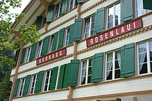
In the core settlement of Willigen in particular, Schattenhalb has numerous well-preserved, valuable individual buildings and groups of buildings from four centuries. Three tours lead past these traditional residential and farmhouses in the Bernese Oberland and other sights.
The “Kraft & Wasser Schattenhalb” foundation, newly established in 2016, was able to take over the Schattenhalb 2 plant with its historic turbines, which was shut down in 2010, and wants to make it accessible to the region's tourist offerings.
Personalities
- Christoph Blocher (* 1940), former Federal Councilor, entitled to live in Schattenhalb
- Simon Sulzer (1508–1585), reformer, born in Schattenhalb
- Raphael Urweider (* 1974), writer, grew up in Schattenhalb
- Kaspar Willi (1935–2014), mountain guide and former community clerk, author of the book Schattenhalb
literature
- Kaspar Willi: Half of the shadow. Mixed community of Schattenhalb 2015, ISBN 978-3-033-04766-2
- Community of Schattenhalb: cultural guide Willigen Rosenlaui
Web links
- Official website of the municipality of Schattenhalb
- Anne-Marie Dubler : Half of the shadow. In: Historical Lexicon of Switzerland .
- Andreas Staeger: Half of the shadow. How Christoph Blocher got a home. In: Tagesanzeiger, December 13, 2014
Individual evidence
- ↑ Permanent resident population from STAT-TAB of the BfS , municipalities see also regional portraits 2020 on bfs.admin.ch, accessed on May 29, 2020
- ↑ Daniel Salzmann: On the Alp Grindel cheese is made at 2100 meters . Swiss farmer from August 5, 1915
- ^ Community of Schattenhalb: cultural guide Willigen Rosenlaui


