
Lounging
| Lounging | |
|---|---|
 |
|
| State : |
|
| Canton : |
|
| District : | No district division |
| BFS no. : | 1405 |
| Postal code : | 6078 |
| UN / LOCODE : | CH LGN |
| Coordinates : | 655061 / 181 876 |
| Height : | 712 m above sea level M. |
| Height range : | 562–2480 m above sea level M. |
| Area : | 46.47 km² |
| Residents: | 2120 (December 31, 2018) |
| Population density : | 46 inhabitants per km² |
|
Proportion of foreigners : (residents without citizenship ) |
11.6% (December 31, 2,015) |
| Website: | www.lungern.ch |
 Lounging |
|
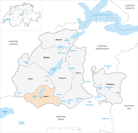
| Location of the municipality | |
  |
|
Lungern is a municipality in the canton of Obwalden in Switzerland and is located on the Lungerersee at the foot of the Brünig Pass .
geography
Lungern is in the uppermost part of the canton of Obwalden. The village center is at an altitude of 712 m above sea level. M. , the train station at 752 m above sea level. M. As the highest altitude village in Sarneraatal it lies in a valley, which is open only to the north and is enclosed on the other sides by steep, wooded slopes and rocks. The municipal ban extends over an area of 4647 hectares, of which 1775 hectares are meadow and pasture land, 463 hectares of garden and humusified area, 2022 hectares of forest, 17 hectares of built-up area, 80 hectares of traffic area, 208 hectares of water and 81 hectares of unused area.
The village is divided into three districts. At the northern end of the lake lies Kaiserstuhl-Bürglen on the adjacent hills , while the actual village center has settled on the eastern shore of the lake. The hamlet of Obsee adjoins the southern shore of the lake and can be described as the best-preserved part of the old village. Here you can still find old houses in their original arrangement.
history

The first documentary evidence of Lungern can be found in 1275 in a tax code of the diocese of Constance . Individual finds from the Mesolithic , Bronze and Roman times attest to the prehistoric settlement as well as the inspection of the route over the Brünig Pass . In 1987, during drilling and explorations on the Römerweg in Lungern, fragments were found that were dated to the time of 1000 BC. During further excavations a knife made of rock crystal was found, which was assigned to a time around 6000 years before Christ.
- 1275: first documentary evidence of Lungern
- 1861: Construction of the old Brünigstrasse
- 1886: first stagecoach across the Brünig
- 1888: the last stagecoach across the Brünig
- 1888: The road from Brienz to Alpnachstad is opened
- 1887: The Eibach is flooded and the old church is swept away
- 1893: Blessing of the newly built neo-Gothic church
- 1922: Construction of the power station
- 1942: electric train across the Brünig
- 1960: Lungern-Schönbüel cable car
Lowering and re-damming of the Lungernsee
To reclaim land, the population of Lungern decided towards the end of the 18th century to deepen their lake. The company split the village population into two parties, namely "diä Nasse and diä Trochenä". What was utopian and impracticable for some was a necessary act to improve living conditions for others.
After measurements had shown that about 180 hectares of pastureland could be obtained by lowering the lake by 35 m, the reports required for the state government were drawn up. In 1790 the actual construction work could begin. Political unrest, lack of money and sectarian tensions delayed the whole project. On January 9, 1836, the last blast was carried out on the 410 m long canal through the rock that closed the lake basin at its northern end near Bürglen. This lowered the lake level by 35 m and thus gained new pastureland.
Almost a century later, the Centralschweizerische Kraftwerke (CKW) in Lucerne bought the whole lake with the ground and the existing houses as well as a small sawmill. At that time there were about twelve residential buildings in the lake floor. Various well-preserved houses were demolished and rebuilt in the municipality of Lungern. In order to operate the power plant on Lungernsee, the CKW dammed the lake again in 1922 and increased the level again in 1926. The Elektrizitätswerk Obwalden (EWO) has been operating the Lungerersee power station since 1982 .
coat of arms
Originally the municipality of Lungern had a blue coat of arms with a silver (white) straight-armed paw cross . Early 19th century was felt the old coat of arms as a very simple and it was decided in Milan to give a new coat of arms (Mailänderli) in order. A Milanese artist designed a fantasy coat of arms without any reference to the municipality of Lungern. At the Maiengemeinde in 1952, the Lungernians decided to recognize the old coat of arms again as the community coat of arms.
population
In the 18th century there was a strong growth in the population despite the high child mortality rate. Between 1743 and 1900 the number of residents grew by around 110 percent. In the following decade the population decreased. The reason for this was the lack of jobs and the resulting migration to other regions of Switzerland and overseas. A second growth phase followed between 1910 and 1950 (+10.7 percent). After that, due to the remote location far from metropolitan areas, it stagnated until 1990. Since then, the population has grown by 14.04% or 261 people.

Population development of Lungern since 1743. Source: Cantonal censuses, Federal censuses (1850–2000), Federal Statistical Office (2010)
languages
Almost the entire population speaks Obwalden German, a high Alemannic dialect in Swiss German. In the 2000 census, 94.8% said German, 2.2% Albanian, 0.7% French, 0.5% each Portuguese and Serbo-Croatian and 0.3% Italian as their main language.
Religions - denominations
The population used to be fully members of the Roman Catholic Church. The denominational relationships in 2000 still show this original structure: 1,634 people were Catholic (83.16%). There were also 7.99% Protestant and 1.02% other Christians (mostly Orthodox Christians), 2.24% Muslims and 2.19% non-denominational. 63 people (3.21%) did not provide any information about their creed. The secularization of the church and immigration from other parishes and abroad has led to an increase in other confessional groups in Lungern.
Origin - nationality
| origin | Share in percent |
|---|---|
| Community citizen | 54.3 |
| Swiss citizen | 35.0 |
| Foreigners (without Swiss citizenship) | 10.7 |
Of the 2,120 residents at the end of 2018, 1,892 (89.25%) were Swiss citizens. The majority of the immigrants come from Central Europe (Germany 63, Austria 18 and United Kingdom 9 people), Southern Europe (Portugal 26, Italy 11 and Spain 7 people), the former Yugoslavia (Serbia 10, North Macedonia 9 and Kosova 2 people), Africa (Eritrea 29 people) and Asia (Sri Lanka 6 and Syria 5 people). At the 2000 census, 1,827 people (92.98%) were Swiss citizens; 33 of them had dual citizenship.
age structure
The municipality has a high proportion of middle-aged residents. While the proportion of people under the age of twenty makes up 20.28% of the local population, 28.73% are senior citizens (60 years and older). The largest age group are people between 45 and 59 years. For every 100 people of working age (20–64 years; 1223 people) there are 35 young people (430 people) and 38 people (467 people) of retirement age.
The following age structure emerged at the end of 2018:
| Age | 0–6 years | 7-15 years | 16-19 years | 20-29 years | 30–44 years | 45–59 years | 60–79 years | 80 years and more | |||
| number | 148 | 197 | 85 | 253 | 342 | 486 | 473 | 136 | |||
| proportion of | 6.98% | 9.29% | 4.01% | 11.93% | 16.13% | 22.92% | 22.31% | 6.42% | |||
| Source: Federal Statistical Office, population by age at the end of 2018 | |||||||||||
economy
In economic terms, agriculture, forestry and the timber industry are predominant. For example, Holzbau AG Lungern (founded in 1926, active until 1983) also delivered numerous buildings outside of Obwalden. The village has also had a tradition in the field of sculpture since around 1920, which can also be seen from the numerous grave monuments in the Lungern cemetery. In addition, a number of specialist companies are located in Lungern, such as Gasser Felstechnik and Westiform Holding .
In 2008 there were 1036 employees in 146 companies in Lungern. 13.5% of the employees in Lungern worked in agriculture / forestry / fishing (sector 1), 46.4% in industry and trade (sector 2) and 40.1% in service companies (sector 3). The unemployment rate in 2011 was 0.68%.
In 2017, 776 of the 1,161 employees were male and 385 female. The numbers for the 3 sectors are as follows:
| Companies 1st sector |
Employees 1st sector |
Full-time positions 1st sector |
Companies 2nd sector |
Employees 2nd sector |
Full-time positions 2nd sector |
Companies 3rd sector |
Employees 3rd sector |
Full-time positions 3rd sector |
Operations total |
employees Total |
Total full-time positions |
|
| number | 54 | 142 | 88 | 40 | 677 | 596 | 83 | 342 | 217 | 177 | 1161 | 901 |
| proportion of | 30.51% | 12.23% | 9.77% | 22.60% | 58.31% | 66.15% | 46.89% | 29.46% | 24.08% | 100% | 100% | 100% |
| Source: Federal Statistical Office; Statistics of the company structure STATENT, workplaces and employees by municipality and economic sector | ||||||||||||
Agriculture
The rights, duties and benefits of the Alps, the forest and part of the garden have always been regulated in the “Einig” (litter regulation) and in the Forest Ordinance. The management of the Alps during the summer months has always been of existential importance, as valley and hillside properties are insufficient to feed the cattle all year round. While the hay is brought in in the valley and the barns are filled with winter supplies, the farmers move their cows and cattle to the Alps. The foothills of the Alps are bumped around the beginning of June, after a few weeks the alpine farmers move to the high Alps and then back to the foothills in mid-August, after which they return to the valley.
traffic
The main road 4 (Brünigstrasse) combines lounging with the neighboring village of Giswil and over the Brünigpass to Meiringen in the Bernese Oberland . The Lungern bypass tunnel , which relieves the village of through traffic, was put into operation in December 2012 after a 6-year construction period.
Lungern can be reached with the Zentralbahn (formerly Brünigbahn ). There are two stops, Kaiserstuhl and Lungern . The trains no longer stop at the former Käppeli stop a little above the village. For the ascent to the Brünig Pass and for the descent from Kaiserstuhl-Bürglen to Giswil , the railway uses a cogwheel support .
Culture and leisure

- Panorama world Lungern-Schönbüel , mountain region at 2205 m above sea level. M.
- Brünig Indoor , underground shooting range
- Brünig Park, venue
Attractions
Churches


The old parish church of St. Katharina was hit by a series of floods from the Eibach in the 1880s. The flood in 1887 was so severe that it tore away the entire church and ossuary except for the tower. The late Romanesque tower made of quarry stones was dated to 1389 using dendrochronology and has been a listed building since 1991.
The new church is the work of architect Josef Tugginger from Alsace . It is built like a cathedral in the neo-Gothic style. The construction work took place in the years 1891/93. The new church was consecrated on All Saints' Day in 1893 by Bishop Johannes Fidelis Battaglia of Chur in honor of the Sacred Heart of Jesus as well as St. Catherine and St. Beat .
In the former ossuary next to the old parish church of St. Katharina, there was a dance of death painting from around 1621 with probably eight dancing couples (pope, cardinal, bishop, priest, emperor, king, knight, farmer) until 1887. The earlier monologues of the death figure have been preserved.
Personalities
- Hans Gasser (1902–1985), national councilor, government councilor and entrepreneur
- Hans-Heini Gasser (* 1932), councilor, civil engineer, pioneer of ski jumping hill construction
- Albert Gasser (* 1938), theologian and church historian
- Luke Gasser (* 1966), filmmaker, sculptor, painter, musician, actor and book author
- Karl Imfeld (* 1953), sculptor
- Karl Vogler (* 1956), member of the National Council and lawyer
literature
- Albert Vogler: Chronicle of Lungern. Self-published, Lungern 2008.
Web links
- Official website of the municipality of Lungern
- Josef Halter: Linger. In: Historical Lexicon of Switzerland .
Individual evidence
- ↑ Permanent and non-permanent resident population by year, canton, district, municipality, population type and gender (permanent resident population). In: bfs. admin.ch . Federal Statistical Office (FSO), August 31, 2019, accessed on December 22, 2019 .
- ↑ http://www.statistik-obwalden.ch/index.cfm?navid=83&docid=83
- ^ National map of Switzerland 1: 25000, sheet 1210 Innertkirchen
- ↑ Numbers, facts, data information page on the website of the municipality of Lungern, accessed on August 28, 2012
- ↑ Hans-Heini Gasser : The early history of Lungern. In: Parish history of Lungern. Küchler Druck, Giswil 1994.
- ↑ Numbers, facts, data from Lungern Information page on the website of the municipality of Lungern, accessed on February 23, 2020
- ^ Frank Bürgi: Early modern architecture from the factory. Holzbau AG Lungern 1925-1935 , Schwabe Verlag, Basel 2015
- ↑ The Lungerer School . In: Obwaldner Zeitung, October 19, 2016
- ↑ «Gravestones were a surefire thing» . In: Obwaldner Zeitung from October 31, 2016
- ↑ Gasser's work of art is back in Lungern . In: Obwaldner Zeitung from October 31, 2014
- ↑ Lungern will be bypassed with immediate effect , online article in the Neue Zürcher Zeitung from December 10, 2012
- ↑ Project description bypass Lungern on the web server of the Obwalden civil engineering office
- ^ Website of the mountain area Panoramawelt Lungern-Schönbüel
- ↑ Website of the Brünig Indoor underground shooting range
- ↑ Brünig Park - experience «Fascination Rock»! Retrieved May 3, 2017 .
- ↑ Hans Georg Wehrens: The dance of death in the Alemannic language area. «I have to do it - and don't know what». Schnell & Steiner, Regensburg 2012, ISBN 978-3-7954-2563-0 , p. 198.