
Giswil
| Giswil | |
|---|---|
 |
|
| State : |
|
| Canton : |
|
| District : | No district division |
| BFS no. : | 1403 |
| Postal code : | 6074 |
| Coordinates : | 656 920 / 187179 |
| Height : | 484 m above sea level M. |
| Height range : | 469–2343 m above sea level M. |
| Area : | 85.91 km² |
| Residents: | 3658 (December 31, 2018) |
| Population density : | 43 inhabitants per km² |
|
Proportion of foreigners : (residents without citizenship ) |
10.8% (December 31, 2,015) |
| Website: | www.giswil.ch |
 |
|
| Location of the municipality | |
  |
|

Giswil is a municipality in the canton of Obwalden in Switzerland .

geography
The village of Giswil is located in the south of the valley area of the canton of Obwalden dominated by Lake Sarnen at an altitude of 484 m above sea level. M. as well as mountain areas west of the valley. The lowest point is the Sarnersee at 469 m above sea level. M. , the highest point is 2220 m above sea level. M. , just below the summit of the Brienzer Rothorn ( 2349.7 m above sea level ).
The north-western mountain area consists of an unstable rock stratification ( flysch ) made of sand-lime stone, clay and gypsum and is mainly used for forestry. The mountain areas in the southwest and in the east consist of stable rocky limestone and are used for agriculture and forestry. The mountain foot region in the west consists of fluvial scree deposits and is used for agriculture, as settlement area and for gravel extraction, and the valley floor consists of largely drained wetlands and is used as settlement, industrial and agricultural areas.
The total area of the municipality is 8,597 hectares , of which 4,541 hectares (52.8%) are wooded areas (with forest and scrub), 3,195 hectares (37.2%) are usable areas (such as meadows, fields, Alps), 158 hectares (1, 8%) settlement areas and the rest (703 ha 8.2%) unproductive (bodies of water, mountains without vegetation).
With an area of almost 86 km², Giswil is the same size as the city of Zurich. In a comparison of the size of the 2750 Swiss municipalities, Giswil ranks 68th.
The development in the community of Giswil extends over a large area, so in large parts the place has the character of a scattered settlement . Giswil has no administratively or politically delimited subdivision, but is made up of the settlement areas Grosteil , Kleinteil , Rudenz and Diechtersmatt , which can therefore be described as districts. The now closed settlement around Diechtersmatt has grown together with the older district of Rudenz to the south. This area, in which the train station is also located, now forms a kind of village center. Aaried, adjacent to the south, was created when the Rudenzersee was drained in the 19th century and is mainly used as pastureland. The Kleinteil district is located more than two kilometers southwest of the village between the Altibach and Laui streams at the northeastern foot of the Giswilerstock. Closer to the village is the main settlement of Schribersmatt in the Grossteil district with its school and sports facilities. Numerous farms and alpine farms, which spread over an area of several square kilometers, belong to the district of Grossteil between Laui and Steinibach.
Waters
The water from the Lungerersee is used to generate electricity after a pressure pipe with a 190 meter gradient in the Unteraa power plant (formerly Lungerersee power plant). The turbines and generators of the power plant are located in the underground cavern center Unteraa , which is located in the area of the municipality of Giswil. From there the water flows as the Sarner Aa (also simply called Aa , Aawasser or Giswiler Aa in this section ) in a canalised stream bed until it joins the Laui and the Kleine Melchaa to form the Dreiwässerkanal. This flows into Lake Sarnen after about 2 km . The community of Giswil has a small part of the Sarnersee, namely in the area west of the mouth of the Dreiwässerkanal.

The community is shaped by the Laui. This has often brought mischief to the community. So in 1629 they swept away the old parish church and forced the Giswilers to give up an entire part of the village. This catastrophe fell in the era of the witch hunts . Someone was to blame for this flood and the destruction of the Church. The pastor recognized the culprits in his parish, and so it came to the largest witch hunt in the history of Switzerland in Giswil. Sixty-three people, in addition to the "witches" seven men and five children (four boys and one girl), were tortured, sentenced to death by the sword, executed, quartered and burned. According to tradition, the execution took place at the place where the old church stands today, which was built on the foundations of the tower of the destroyed church.
With severe thunderstorms and prolonged rainfall in its unstable source region, the Laui can still pose a threat today. The danger of the creek was reduced with high dams and other measures. A gravel works is operated in its streambed.
The Kleine Melchaa leaves the last narrow gorge of the Kleiner Melchtal east of the district of Diechtersmatt and then flows through the middle of the district. Between 1936 and 1984 severe weather events in the Kleiner Melchtal resulted in floods in the Diechtersmatt settlement area five times. Even when the Alpine floods in 2005 , the Kleine Melchaa had become a torrent, and large parts of the settlement area were severely damaged. Therefore, the hydraulic engineering project Kleine Melchaa was started in 2011 to improve flood protection . The construction work, with a planned cost of 16 million francs, includes the construction of the Gorgen sediment collector and the relocation of the channel from the Gorgen area in a direct line to the Sarnersee. The sediment collector Gorgen has a wall around 12 meters high and over 100 long with space for 70,000 m³ of debris and is being built east of the Diechtersmatt district. The construction work started in September 2011 and should be completed by 2015.
population
Population development
The number of residents stagnated between 1744 and 1799. This is because of the small amount of agricultural land in the swampy plain south of Lake Sarnen and natural disasters in the form of floods. The population in the municipality then grew sharply between 1799 and 1850 (1799-1850: +55.3%). The reason for this was a strong surplus of births and the draining of swampy areas. There was a small population decline between 1850 and 1860, but this was more than made up for in the 1860s. In the years between 1870 and 1888 there was a strong wave of emigration to the industrialized areas of Switzerland and overseas (Brazil and the United States). This stopped thanks to the connection to the Brünig Railway in 1888. There was then a growth phase until the beginning of the First World War (1888–1910: + 22.5%). This was followed by a decade of zero growth. The population grew over the next eighty years of the 20th century, apart from a period of stagnation in the 1950s and a decline in the 1970s (1970–1980: −6.0%). Overall, the number of residents rose by 1,585 or 80.9% between 1920 and 2000. However, it has only grown slowly since the turn of the millennium.
The reason for the increase was the improvement in public transport and, above all, the construction of the A8 . The community also became attractive for commuters because of its proximity to the Obwalden capital Sarnen and the city of Lucerne .
| year | 1744 | 1799 | 1850 | 1860 | 1870 | 1880 | 1888 | 1900 | 1910 | 1920 | 1930 | 1941 | 1950 | 1960 | 1970 | 1980 | 1990 | 2000 | 2010 |
|---|---|---|---|---|---|---|---|---|---|---|---|---|---|---|---|---|---|---|---|
| Residents | 1,040 | 1,037 | 1,610 | 1,579 | 1,782 | 1,786 | 1,579 | 1,711 | 1,934 | 1'959 | 2,382 | 2,437 | 2,653 | 2,656 | 2,760 | 2,595 | 3,085 | 3,435 | 3,613 |

languages
Almost the entire population speaks Obwalden German, a high Alemannic dialect in Swiss German. At the last census in 2000, 95.5% said German, 1.02% Serbo-Croatian and 0.82% Portuguese as their main language.
Religions - denominations
The population used to be fully members of the Roman Catholic Church. The denominational relationships in 2000 still show the original structure despite the mixture. 2,913 people were Catholic (84.80%). There were also 7.13% Protestant and 0.87% Orthodox Christians, 1.57% Muslims and 3.23% non-denominational. 72 people (2.10%) did not provide any information on their creed. Until a few decades ago, almost the entire population was Catholic. The secularization of the church and the high level of immigration from other communities and abroad has led to a rapid rise in other confessional groups in Giswil.
Origin - nationality
Of the 3,658 residents at the end of 2018, 3,249 (88.82%) were Swiss citizens. The majority of the immigrants come from Central Europe (Germany 112, Poland 12 and Austria 8 people), Southern Europe (Portugal 125, Italy 17 and Spain 10 people), the former Yugoslavia (Kosova 33 and Serbia 9 people) and Sri Lanka (9 people). At the 2000 census, 3,180 people (92.58%) were Swiss citizens; 63 of them had dual citizenship.
Of the 3,662 inhabitants at the end of 2019, according to the municipality, 1157 (31.59%) were municipality citizens, 2085 (54.75%) were Swiss residents and 420 (11.47%) were foreigners.
age structure
The church had a high percentage of younger people in 2000. While the proportion of people under the age of twenty made up 30.42% of the local population, 16.86% were seniors (60 years and older).
The last census in 2000 showed the following age structure:
| Age | 0–6 years | 7-15 years | 16-19 years | 20-29 years | 30–44 years | 45–59 years | 60–79 years | 80 years and more |
| number | 314 | 539 | 192 | 372 | 884 | 555 | 457 | 122 |
| proportion of | 9.14% | 15.69% | 5.59% | 10.83% | 25.74% | 16.16% | 13.30% | 3.55% |
The community now has a high proportion of middle-aged residents. While the proportion of people under the age of twenty makes up 20.69% of the local population, 24.08% are senior citizens (60 years and older). The largest age group are people between 45 and 59 years. For every 100 people of working age (20–64 years; 2282 people) there are 33 young people (757 people) and 27 people (619 people) of retirement age.
The following age structure emerged at the end of 2018:
| Age | 0–6 years | 7-15 years | 16-19 years | 20-29 years | 30–44 years | 45–59 years | 60–79 years | 80 years and more | |||
| number | 252 | 360 | 145 | 442 | 680 | 898 | 705 | 176 | |||
| proportion of | 6.89% | 9.84% | 3.96% | 12.08% | 18.59% | 24.55% | 19.27% | 4.81% | |||
| Source: Federal Statistical Office, population by age at the end of 2018 | |||||||||||
politics
Giswil is run by a municipal council with 7 members. Beat von Wyl has been the mayor since July 2012; Bruno Enz previously held the office. A community meeting takes place twice a year. The Giswilers have been sending five representatives to the Obwalden cantonal council since 2014 , previously there were six representatives because of the higher proportion of the population at the time.
economy
Gainful employment
Up until the 20th century, most of Giswil's residents lived from raising cattle. There was also the milk processing industry (cheese dairy) and a little timber industry. Today there are also companies in the areas of construction, electric motor construction, refrigeration technology and measuring devices.
In Giswil there were (2008) 1,326 employees in 273 companies. 23.6% of the employees in Giswil worked in agriculture / forestry / fishing (sector 1; the municipality has the highest proportion in the entire canton), 31.2% in industry and trade (sector 2) and 45.2% in Service companies (sector 3). The unemployment rate in 2011 was 1.02%.
In 2000 there were 1,077 people in gainful employment in Giswil. Of these, 789 (73.26%) were locals and 288 were commuters. Most of the commuters came from the region; namely from Sarnen (25.0%), Sachseln (24.3%), Lungern (10.1%), Kerns (8.0%) and Alpnach (5.6%). In the same year, 1,721 people from Giswil were gainfully employed. Thus 932 people worked in other communities. 274 people (29.4% of all commuters) commuted to the Obwalden main town of Sarnen, 193 people (20.7%) to Sachseln, 109 people (11.7%) to the city of Lucerne , 62 people (6.7%) to Lungern ), according to Alpnach 49 people (5.3%), according to Kerns 35 people (3.8%), according to Stans 32 people (3.4%), according to Kriens 22 people (2.4%) and according to Emmen 21 people (2.3%).
In 2017, 767 of the 1,338 employees were male and 571 female. The numbers for the 3 sectors are as follows:
| Companies 1st sector |
Employees 1st sector |
Full-time positions 1st sector |
Companies 2nd sector |
Employees 2nd sector |
Full-time positions 2nd sector |
Companies 3rd sector |
Employees 3rd sector |
Full-time positions 3rd sector |
Operations total |
employees Total |
Total full-time positions |
|
| number | 103 | 290 | 178 | 72 | 392 | 341 | 164 | 656 | 442 | 339 | 1338 | 961 |
| proportion of | 30.38% | 21.67% | 18.52% | 21.24% | 29.30% | 35.48% | 48.38% | 49.03% | 45.99% | 100% | 100% | 100% |
| Source: Federal Statistical Office; Statistics of the company structure STATENT, workplaces and employees by municipality and economic sector | ||||||||||||
post Office

The first traces of non-invoicing mail filing in Giswil go back to 1849. After it was converted into a deposit account subject to invoices and money orders in 1866, it was classified as a post office in 1871 (money orders up to CHF 200 possible). In 1888, a contract was signed with the Jura-Bern-Lucerne Railway to rent a post office in the new railway station building. In 1901 the post office was relocated to the house of the postman at the time, Cherubin Steudler. During the Second World War, Giswil also served as a war internment camp post for interned Poles, Italians and Russians. When postmaster Steudler retired in 1947 after 45 years of service and Julius Limacher took over the post office, it was moved to a new building on the small town of Melchaa. The Giswil post office was run by the Limacher (-Lötscher) family until the 1990s. As a result of the strong increase in postal traffic, a more modern and larger post office with a branch of the Obwaldner Kantonalbank is opened in 1991 . It is right next to the building from 1948 in which the Café Alte Post is located.
history
The earliest known mention of Giswil is in a document from 840. At that time it was written “Kisewilare”, which means “belonging to the courts of Giso / Kiso or Kiselbert”.

Giswil was a farm of the Murbach monastery in Alsace. For the Obwalden valley it was also the seat of the monastic administration officials.
In the 13th century the barons of Wolhusen succeeded in uniting Meieramt and Vogtei and largely removed them from the abbot's control. Murbach therefore sold all of his territories in what is now Switzerland to the Habsburgs in 1291.
The Kleinteil district was the center of the community until the church fell in 1629 . In 1607 a first chapel was built for the most part, but only because the way to the parish church was dangerous in the small part. Already in 1429 there were signs of independence for large and small parts. Documents mention two corporations “part rütihalb” and “part kilchehalb”.
As the last valley station on Brünigstrasse, Giswil experienced a strong boom in the second half of the 19th century. With the construction of the Brünigbahn (completed in 1889) the economic rise began. The draining of the Aaried, a swamp area in which marsh fever was spread, also contributed to this. The water power of the Lungerersee could also be used. As a result, the emigration that had been common up until then, which for a long time was subsidized by the municipality with travel money, fell significantly.
During the Second World War , the Giswil replenishment base was an important logistics location for the Reduit (transport and storage of military material) on the axis through the Bernese Oberland . The 8th Division of the Swiss Army erected in 1940 in addition to the Brünig route a winter safe castling Route military cableways from central Switzerland to the Bernese Oberland. Two private cable cars were taken over by the army: The 1927-built cable car room space ( 642 m above sea level. ) ⊙ after Talwald ⊙ (MSB52) and the cable car from the Talalpeli ⊙ to Schälf / Iwi (MSB53) ( 1308 m above sea level. ) ⊙ .
Horse transport has been set up from Schälf / Iwi to Mörlialp . From the valley station Mörlialp (now Berghaus Mörlialp) ⊙ the four-kilometer-long cable car Military MSB50 led on the angle station in Glaubenbielen ⊙ after Habchegg (Mariental, Sörenberg ) ⊙ . From there the road via Salwideli, Kemmeribodenbad to Habchern ( Habkern ) was used. In 1941 the army built a funicular (MSB54) ⊙ from Talwald to Hohnegg (1227 m) .
From autumn 1941, Polish internees built connecting roads across the heights into Entlebuch: Glaubbielenstrasse , Weg zum Sattelpass, Höhenkarrweg Glaubbielen – Sattelpass– Glaubberg and Kilchweg in Giswil.
traffic

The community lies at the northern foot of the Brünig Pass . Both the Brünigbahn and today's Zentralbahn with the S5 of the Lucerne S-Bahn, as well as a main road, which is run as the A8 motorway to Giswil , cross the village. The Giswil bypass tunnel has been relieving the town of heavy through traffic since 2004 , after which, after decades of noise and stench, calm has returned to the tranquil village. The two connections Giswil-Süd and Giswil-Nord still enable optimal transport connections.
For the Brünigbahn, the cogwheel-supported route to Kaiserstuhl OW and on to Lungern and the Brünig Pass begins immediately south of Giswil station .
The road over the Brünig Pass to Meiringen in Oberhasli ( Canton Bern ) was built in the years 1861–1868. Furthermore, the panorama road leads with a gradient of up to 12% past the Mörlialp ski area over the 1611 m high pass Glaubbielen via Sörenberg into Entlebuch to Schüpfheim .
Attractions
The landscape is shaped by Lake Sarnen and the valley floor, surrounded by mountains. The Giswilerstock is particularly striking . In the municipality of Giswil there are many special boulders, so-called name stones .
The historic Giswil hiking trail leads past numerous cultural assets.
The parish church of St. Laurentius stands on the former castle hill of Hunwil. The castle ruins supplied a large part of the material for the new construction of the parish church, which was inaugurated in 1635. Immediately next to it is the ossuary chapel of St. Michael, which was built between 1657 and 1661 and renovated in 2001.
Between the Brünigbahn and Brünigstrasse you will find the Rudenz castle ruins , the former seat of the von Rudenz family. The remains of the Rosenberg castle ruins are in the Kleinteil district between the chapel and the Alpenrösli Hotel.
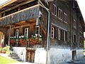
In the valley floor of Giswil there are numerous medieval wooden buildings such as the Schrotenhaus in Schrotenmatt. Through dendrochronological studies it was found that the wood for this house was felled in autumn / winter 1466/67 and then built. This house is probably the oldest house in Giswil or even in the entire canton of Obwalden.
The flail saw from 1877 in the Kleinteil district was rebuilt in 2002 and is thus probably the only operational saw of this type in Switzerland.

Small part with Giswilerstock

St. Laurentius Parish Church

Rudenz castle ruins
Semi-detached house in the Grütli, Kleinteil, 16th century

St. Anton chapel in the small part, built 1664–1667

Doppelspycher Brend, small part, 17th century


Personalities
Honorary citizen
- Ruedi Rymann (1933–2008), yodeler, singer and composer. He is considered one of the most famous Swiss yodellers. His folk song “Dr Schacher Seppli” was voted the biggest Swiss hit in 2007.
Sons and daughters
- Meinrad Burch-Korrodi (1897–1978), goldsmith and collector of graphic art
- Hans Halter (* 1939), Roman Catholic theologian
- Carlo von Ah (* 1940), manager, entrepreneur and writer
literature
- Niklaus von Flüe : Giswil in the 19th century: a village in political and economic change. Edited by the Giswil Local History Association. Giswil 2006 (= Giswil history booklet, issue 6).
- Hans Richard, Jürg Keller: Military cable cars / Téléfériques militaires . Association of Historical Military Facilities Freiburg / Bern VH + MA, annual issue 2016
- Mike Bacher: The military cable car Mörlialp – Glaubbielen – Mariental. In: Around the Giswilerstock. Issue 15 from the series «Giswiler Geschichtsheft». Local History Association Giswil, Giswil 2018.
Web links
- Official website of the municipality of Giswil
- Urs Abächerli: Giswil. In: Historical Lexicon of Switzerland .
- A village center for the population ( memento from March 18, 2012 on WebCite ), article in the ONZ Obwalden and Nidwalden newspaper from April 30, 2010. Archived from the original online version on March 18, 2012.
- The community of Giswil introduces itself in the Aktuell Obwalden , article from February 12, 2014 on obwalden.net, also appeared in the information sheet Aktuell Obwalden .
Individual evidence
- ↑ Permanent and non-permanent resident population by year, canton, district, municipality, population type and gender (permanent resident population). In: bfs. admin.ch . Federal Statistical Office (FSO), August 31, 2019, accessed on December 22, 2019 .
- ↑ http://www.statistik-obwalden.ch/index.cfm?navid=83&docid=83
- ^ Federal Statistical Office FSO: Areal Statistics Standard (NOAS04) 2004/09
- ↑ Federal Statistical Office FSO: Generalized municipal boundaries, level 3: Geodata, 2009, file GG09_XYZ.XLS ( Memento from September 11, 2012 in the Internet Archive ), accessed on September 11, 2012
- ↑ Chapter “Witches' pursuit” in: Pirmin Meier : Switzerland. Mysterious landscape in the shadow of the Alps . Goldmann (Magisch Reisen), 1993, ISBN 978-3-442-12298-1 .
- ↑ Report of the Government Council 2008
- ↑ Current projects, Kleine Melchaa information page on the flood protection website of the canton of Obwalden, accessed on September 15, 2012
- ↑ 3000 cubic meters of concrete for a wall Article in the Neue Obwaldner Zeitung from April 28, 2012
- ^ Giswil online, community in numbers
- ↑ Post structures - PTT archive. Retrieved September 1, 2019 .
- ^ Hans Richard, Jürg Keller: Military cable cars / Téléfériques militaires. Association of Historical Military Facilities Freiburg / Bern VH + MA, annual issue 2016
- ↑ Poland routes through Switzerland
- ↑ Website of the Mörlialp ski area
- ↑ Giswil historical hiking trail (PDF), accessed on October 28, 2019
- ↑ Jakob Obrecht: The Meier Tower small part. In: The castles of Giswil. Zwingel, Rudenz and Rosenberg . Edited by the Giswil Local History Association. Giswil 2008, pp. 31–39 (= Giswil history booklet, issue 10)
- ↑ Media release 6/2004 of the community of Giswil from July 23, 2004 ( memento from September 24, 2015 in the Internet Archive ) on the website of the Giswil Local History Association
- ↑ Article on the small pieces flail saw ( memento from May 3, 2013 in the Internet Archive ) on the website of the Giswil Local History Association
- ↑ Youtube: Kleinteiler flail saw Giswil