
Schüpfheim
| Schüpfheim | |
|---|---|
 |
|
| State : |
|
| Canton : |
|
| Constituency : | Entlebuch |
| BFS no. : | 1008 |
| Postal code : | 6170 |
| UN / LOCODE : | CH SPF |
| Coordinates : | 643 877 / 200070 |
| Height : | 719 m above sea level M. |
| Height range : | 690–1978 m above sea level M. |
| Area : | 38.38 km² |
| Residents: | 4219 (December 31, 2018) |
| Population density : | 110 inhabitants per km² |
|
Proportion of foreigners : (residents without citizenship ) |
8.2% (December 31, 2,015) |
| Website: | www.schuepfheim.ch |
 |
|
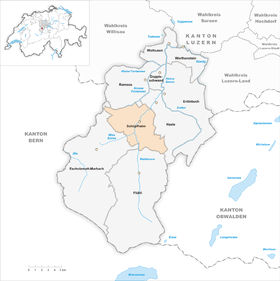
| Location of the municipality | |
  |
|
Schüpfheim ( Swiss German Schüpfe ) is a municipality in the Swiss canton of Lucerne . It belongs to the Entlebuch constituency .
geography
The community is located in the southwest of the canton of Lucerne on the Kleine Emme . In the village itself the Mannenbach flow from the left and the Kirchenbach and the Trüebenbach from the right . The smaller part of the municipality is on the left bank of the Kleine Emme. This part is called the sunny side (Swiss German: Sonnesite ) and Hinterberg . The area has been cleared except for a few forest areas. Only the bank areas on the Blettbach in the southwest and the Bienzenwald in the northwest of Schüpfheim-Dorf are an exception. The area is also heavily forested south of the Grosse Fontannen , which forms the northern municipal boundary.
A little south of the municipality, coming from the left, the Weissemme merge with the Waldemme to form the Kleine Emme. The area between the two Emmen is predominantly forested. The slope on the right bank of the Waldemme and Kleine Emme is called the shady side (Swiss German: shady side ). With the exception of large areas of forest west of the ridge called Farneren, it has been almost completely cleared.
As it runs from south to north, the Waldemme crosses the Lammschlucht gorge it has dug (3–4.5 kilometers south of the village). Coming from the right, the Staubbach flows into it.
The northern boundary of the municipality goes from the Zinggenbrücke , which crosses the Kleine Emme, in a north-westerly direction to the ridge on the sunny side. There she turns to the southwest to Voglisbergegg ( 1039 m above sea level ). From this it goes north to the Grosse Fontanne and then the course of the river in a south-westerly direction upstream to Unter- and Ober Freimoos just before the canton border with Bern . From there it goes in a southerly direction to the Bocken brook , along this, west of the Hinterberg - until it comes to the Weissemme at the Gerbi homestead . In a southerly direction you continue to Gsteigegg , where the border line to Schafmatt ( 1979 m above sea level ; highest point of the municipality) takes an easterly direction. After the mountain, the direction briefly changes along the ridge to the northeast. Then, at Engellauenengrat ( 1902 m above sea level ) the direction turns north. The Engellauenenbach , which rises from the ridge, forms the border up to its confluence with the Grosse Entlen . From there it goes back to the Farneren and then along the Bibernbach to the north. It leaves this to come back to the Zinggen Bridge in the northwest.
The community consists of the village, which continues to expand along both the left and right banks of the Kleine Emme, and numerous groups of houses and individual farms.
60.0% of the municipal area of over 38.51 km² is agricultural land. Another 32.8% are covered by forest and wood and 5.3% are settlement areas.
Schüpfheim borders on Entlebuch , Escholzmatt-Marbach , Flühli , Hasle and Romoos .
population
| Population development | |
|---|---|
| year | Residents |
| 1650 | 1,000 |
| 1781 | 2,180 |
| 1798 | 2,600 |
| 1816 | 3,430 |
| 1837 | 3,333 |
| 1850 | 3'125 |
| 1860 | 2,859 |
| 1888 | 2,793 |
| 1930 | 3,601 |
| 1950 | 3,763 |
| 1970 | 3,773 |
| 1980 | 3,537 |
| 1990 | 3,649 |
| 2000 | 3,897 |
| 2008 | 3,790 |
| 2012 | 4,061 |
| 2013 | 4096 |
| 2014 | 4118 |
| 2015 | 4167 |
| 2016 | 4189 |
| 2017 | 4187 |
| 2018 | 4220 |
| 2019 | 4204 |
The population grew rapidly until 1816 (1798–1816: +31.9%) and then fell again by 1860 as a result of rural exodus (1816–1860: −16.4%). After a phase of stagnation until 1888, there was strong population growth until 1930 (1888–1930: +28.9%). This is very unusual for the Entlebuch. But Schüpfheim benefited from its political importance as the capital of the Entlebuch office. The population grew slightly until 1950, after which it came to a standstill and plummeted in the 1970s (1970–1980: −6.3%). In the following two decades there was great growth, but then the number of inhabitants decreased again. The reason for this is the lower birth surplus, which in previous years more than compensated for the loss of emigration.
languages
The population uses a highly Alemannic dialect as colloquial language. This differs in part from the one spoken in the city of Lucerne and has many similarities with the neighboring Bernbiet (Canton Bern). At the last census in 2000, 96.02% stated German, 1.21% Serbo-Croatian and 0.95% Albanian as their main language.
Religions - denominations
In earlier times the entire population was members of the Roman Catholic Church. In order to prevent the spread of the strong Anabaptism in the neighboring Emmental, there were frequent visitations to check the faithfulness of the Entlebuchers. Of the inhabitants in Schüpfheim today (as of 2000) 87.22% are Roman Catholic, 5.21% Evangelical Reformed and 1.54% Orthodox Christians. There are also 1.10% Muslims and 1.03% non-denominational.
The Catholics belong to the diocese of Basel under canon law or to the Catholic Church in the Canton of Lucerne under constitutional law , the Reformed to the Evangelical Reformed Church of the Canton of Lucerne .
Origin - nationality
At the end of 2014, of the 4,111 residents, 3,780 were Swiss and 331 (= 8.0%) were foreigners. The population consisted of 92.0% Swiss citizens. At the end of 2014, the foreign residents came from Germany (21.8%), Serbia including Kosovo (15.7%), Portugal (3.0%), Italy (1.8%) and Turkey (1.5%). 18.1% came from the rest of Europe and 38.1 % came from outside Europe.
history

The current municipality of Schüpfheim was settled by Alemanni in the 9th century. Their first settlements were on the terraces along the range of hills on the sunny side. Settlement of the valley floor can only be documented from 1173 onwards. The community is mentioned for the first time as Schipfen in Acta Murensia , the property register of the Muri monastery . For a long time the community belonged to the barons of Wolhusen. Around 1300 they sold their property to the Habsburgs . They pledged the area to Peter von Thorberg around 1350 due to financial difficulties . He made himself so hated by the population that the entire Entlebuch concluded an eternal alliance with the city of Lucerne in 1385 . The Lucerne people interpreted the federal government as submission to their rule. The Entlebuch rose against Lucerne several times (1434 for the first time, then in 1513 in the so-called onion war and in 1653 in the Swiss Peasants War ). After the end of the Old Confederation, Schüpfheim was the capital of the Schüpfheim district from 1798 to 1803. Thereafter, the community was the main town of the then newly created Entlebuch office , until its abolition in 2007. On May 27, 1829, the village was ravaged by a devastating village fire. Of the 34 village houses, 22 burned down completely. The reconstruction was accompanied by disputes between the village population and the Lucerne authorities. Points of contention were the alignment of the new Dorfstrasse and the strict building regulations. Finally, an agreement was reached on the construction of today's broad village street. The community of Schüpfheim in its current size was created in 1836 when the community of Flühli was separated from Schüpfheim.
Attractions
politics
Municipal council
The community council of Schüpfheim consists of five members and is set up as follows:
- Christine Bouvard Marty (CVP): Mayor; Presidium / culture / trade
- Wendelin Emmenegger (CVP): Finance / Construction / Infrastructure
- Regula Heuberger Häfliger (CVP): Social affairs / health
- Reto Zemp (FDP): Youth / Education / Sport
- Erwin Dahinden (SVP): Security / Economics / Spatial Planning
Community clerk is Willy Schmid
Cantonal elections
In the 2015 Cantonal Council elections for the Canton of Lucerne, the share of the vote in Schüpfheim was: CVP 44.6%, SVP 29.3%, FDP 17.8%, GPS 4.4%, SP 3.9%.
National Council elections
In the 2015 Swiss parliamentary elections, the share of the vote in Schüpfheim was: SVP 34.4%, CVP 33.5%, FDP 16.2%, SP 8.2%, GPS 3.2%, glp 2.8%, BDP 0, 9%.
traffic

Schüpfheim is on the Lucerne – Bern railway line and has a train station. There is also a post bus line from Schüpfheim via Flühli and Sörenberg via Glaubbielen to Giswil in the canton of Obwalden (called Panoramastrasse).
On October 17, 1943 there was a railway accident in Schüpfheim . The station manager placed the entry point under the penultimate car of a passing Lucerne – Bern express train . The two cars derailed and hit the locomotive of the opposite train waiting for the train to cross . The two cars were badly damaged, six people died and around fifty passengers were injured, some seriously.
The community is located on Hauptstrasse 10 , which connects Schüpfheim with Lucerne, Wolhusen, Langnau BE and Bern. The closest motorway is the A2, 35 km away, with the motorway connections Emmen Nord and Emmen Süd. The next motorway connection for traveling north is also on the A2 in Dagmersellen, 36 km away.
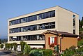
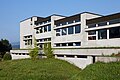
photos

Schüpfheim

Village schoolhouse
Schoolhouse Moosmättli

Moosmättli sports facility
Cantonal school / grammar school

Capuchin monastery

Alpine descent


Personalities
- Kaspar Unternährer (1621–1653), farmer leader
- Anton Unterährer, called Mettlentoneli (1759–1824), carpenter, miracle doctor and founder of the antinomist sect of the Antonians
- Joseph Gaspard Schumacher (1776–1847), military person in Napoleonic service
- Emil Enzmann (1921–2016), doctor and car designer
- Joseph Röösli (1935–2018), clergyman, composer and church musician
- Walter Wobmann (* 1957), car mechanic, businessman and National Councilor of the SVP
- Bruno Schaller (* 1958), teacher, journalist and pilot
- Fabian Schnyder (* 1985), ice hockey player
literature
- Heinz Horat: The art monuments of the canton of Lucerne. New edition, Volume I: The Entlebuch Office (= Art Monuments of Switzerland. Volume 80). Edited by the Society for Swiss Art History GSK. Bern 1987, ISBN 3-7643-1900-3 , pp. 289-356.
- Peter Mulle: Schüpfheim. In: Historical Lexicon of Switzerland .
Web links
- Official website of the community of Schüpfheim
- Community profile of the cantonal statistical office (PDF; 111 kB)
Individual evidence
- ↑ Permanent and non-permanent resident population by year, canton, district, municipality, population type and gender (permanent resident population). In: bfs. admin.ch . Federal Statistical Office (FSO), August 31, 2019, accessed on December 22, 2019 .
- ↑ Permanent resident population according to nationality category, gender and municipality ( memento of the original from January 1, 2015 in the Internet Archive ) Info: The archive link was inserted automatically and has not yet been checked. Please check the original and archive link according to the instructions and then remove this notice. (Permanent resident population)
- ↑ Josef Bühler (1939): Changes in the landscape, economy and settlement of Entlebuch , sheets for local history from Entlebuch No. 10-12, p. 918
- ^ Emil Emmenegger (1978): Schüpfheim through the ages, p. 94 f.
- ↑ Balance of the permanent resident population according to demographic components, institutional structure, nationality and gender (Federal Statistical Office, STAT-TAB)
- ↑ LUSTAT: Community profile Schüpfheim ( Memento of the original from May 8, 2016 in the Internet Archive ) Info: The archive link was automatically inserted and not yet checked. Please check the original and archive link according to the instructions and then remove this notice.
- ↑ Heinz Horat (1987): The art monuments of the Canton of Lucerne, the Entlebuch office, p. 290
- ↑ Emil Emmenegger (1929): The village fire of Schüpfheim sheets for local history from the Entlebuch, No. 1–3, pp. 1 and 8.
- ^ Emil Emmenegger (1978): Schüpfheim im Wandel der Zeiten , p. 92 f.
- ↑ LUSTAT: Community profile Schüpfheim ( Memento of the original from May 8, 2016 in the Internet Archive ) Info: The archive link was automatically inserted and not yet checked. Please check the original and archive link according to the instructions and then remove this notice.
- ↑ National Council elections 2015: strength of the parties and voter turnout by municipality. In: Results of the National Council elections 2015. Federal Statistical Office, 2016, accessed on June 1, 2016 .
- ^ Results of the accident statistics for the sixth five-year observation period 1943–1947. (PDF, 2.3 MB) Swiss Accident Insurance Fund, accessed on October 18, 2013 .
Doppleschwand | Entlebuch | Escholzmatt-Marbach | Flühli | Hasle | Romoos | Schüpfheim | Werthenstein | Wolhusen
Former municipalities: Escholzmatt | Marbach | Chess | Wolhusen Market
Canton of Lucerne | Constituencies of the Canton of Lucerne | Municipalities of the Canton of Lucerne