Romoos
| Romoos | |
|---|---|
| State : |
|
| Canton : |
|
| Constituency : | Entlebuch |
| BFS no. : | 1007 |
| Postal code : | 6110 (Fontannen near Wolhusen) 6113 (Romoos) 6167 (Bramboden) |
| Coordinates : | 644 736 / 206778 |
| Height : | 790 m above sea level M. |
| Height range : | 605–1371 m above sea level M. |
| Area : | 37.39 km² |
| Residents: | 666 (December 31, 2018) |
| Population density : | 18 inhabitants per km² |
|
Proportion of foreigners : (residents without citizenship ) |
2.8% (December 31, 2,015) |
| Website: | www.romoos.ch |
|
Village center of Romoos |
|
| Location of the municipality | |
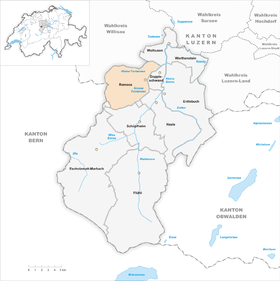
Romoos is a municipality in the Entlebuch constituency in the canton of Lucerne in Switzerland .
geography
The municipal boundary of Romoos runs almost exclusively along natural borders. The Great Fontanne forms the eastern and southern borders. Shortly before the border with the canton of Bern , at Unter Freimoos , it turns north and meets the border with the canton of Bern at the Hängelenfluh farmstead . This then runs along a ridge in a northerly direction to the Hengst ( 1372 m above sea level ). The Krachenbach rises north of the stallion . The municipality boundary to Hergiswil near Willisau runs along its course . After a few kilometers, the Krachenbach flows from the left into the Kleine Fontanne , which rises to the east of the Hengst. The Kleine Fontanne then forms the border to the communities of Menznau and Wolhusen until it merges with the Grosse Fontanne zur Fontannen .
The entire municipality is located in the foothills of the Alps, in the eastern part of the Napfbergland and is very hilly, sometimes even mountainous, and in many cases heavily forested. The hills between the individual streams are partly cleared.
Romoos-Dorf is located on a hill between the Grosse Fontanne in the east and the Altmühlebach in the west and north. In the Altmühlebach which flows from left computing Lochbach one. Shortly after this union, it flows into the Grosse Fontanne from the left. The Goldbach rises to the east of the Bernese cantonal border and flows first eastwards and then southwards and joins the Seeblibach . This rises, however, much further south than the Goldbach, also near the border with the canton of Bern. It flows first in an easterly, then in a south-easterly direction and joins the Grosse Fontanne from the left.
In addition to Romoos-Dorf, there are numerous individual farms and groups of houses in the municipality. The only larger settlement is Bramboden . This is at 1053 m above sea level. M .; 4.8 km southwest of the village.
Of the municipal area of over 37 km², 61.8% is covered by forest. Only 34.8% is used for agriculture, but it is partly barren soil, the yield of which is significantly lower than in the flatlands. Only 2.2% of the municipal area is settlement area.
Romoos borders the municipality of Trub in the canton of Bern to the west . All other municipalities are in the canton of Lucerne. Clockwise, these are Hergiswil in the north-west, Menznau in the north, Wolhusen in the north-east, Doppleschwand in the east, Entlebuch (exclave Dieplischwand ) and Hasle in the south-east, Schüpfheim in the south and Escholzmatt-Marbach in the south-west.
population
| Population development | |
|---|---|
| year | Residents |
| 1780 | 1,135 |
| 1798 | 1,395 |
| 1816 | 1,451 |
| 1837 | 1,610 |
| 1850 | 1,629 |
| 1900 | 1,194 |
| 1910 | 1,244 |
| 1990 | 724 |
| 2000 | 732 |
| 2004 | 745 |
The number of residents rose sharply from 1780 to 1837 (1780–1837: +41.9%). The reason for this was the high birth surplus . After a phase of stagnation until 1850, a strong wave of emigration to the industrial centers and America began in the second half of the 19th century (1850–1900: −26.7%). After a small upswing in the 1900s, a true exodus followed until 1990 (1910–1990: −41.8%). 1990 was the year with the historically lowest number of inhabitants - 55.6% fewer inhabitants than at the highest level in 1850. Since then the number of inhabitants has grown very slightly (1990–2004: + 2.9%).
languages
The population uses a highly Alemannic dialect as their everyday language. The Entlebuch dialect is strongly influenced by the neighboring Emmental and differs significantly from the Lucerne dialect. At the last census in 2000, 98.50% said German, 0.68% Albanian and 0.41% Portuguese were their main languages.
Religions - denominations
In the past, all residents were members of the Roman Catholic Church. Even today the population is much more devout than in the urbanized regions of Switzerland. Today (as of 2000) the religious composition of the population is as follows. There are 91.39% Roman Catholic and 4.51% Evangelical Reformed Christians. There are also 0.68% Muslims and 0.41% non-denominational. The Muslims are of Albanian origin.
Origin - nationality
At the end of 2014, 653 of the 663 inhabitants were Swiss and 10 (= 1.5%) foreigners. The population consisted of 98.5% Swiss citizens. At the end of 2014, the foreign residents came from Germany (70.0%). 20.0% came from the rest of Europe and 10.0% were of non-European origin.
history
Romoos is mentioned for the first time under the name Rormoos in 1184 in a document from the barons of Wolhusen. Later it nominally belonged to the Habsburgs . Before the Battle of Sempach , the Entlebuchers joined the up-and-coming city of Lucerne . Because of the stubborn aversion of the Entlebuchers to foreign masters, the rulers often remained hostile to the rulers in the city. The first uprising of the Entlebuchers against Lucerne took place in 1434. And the Entlebuchers were very active in the Peasants' War in 1653. Romoos belonged to the district of Schüpfheim in the Helvetic Republic from 1798 to 1803 and since then to the then newly created Entlebuch office .
Attractions
politics
Municipal council
The Romoos council consists of three members and is set up as follows:
- Willi Pfulg: Mayor
- Ruedi Lustenberger: Mayor
- Jolande Unterstährer: Social Director
Cantonal elections
In the 2015 cantonal elections for the canton of Lucerne, the proportion of voters in Romoos was: CVP 56.7%, SVP 23.9%, FDP 16.2%, GPS 1.9%, SP 1.4%.
National Council elections
In the 2015 Swiss parliamentary elections, the share of the vote in Romoos was: CVP 48.4%, SVP 34.4%, FDP 11.4%, SP 2.5%, GPS 1.0%, glp 0.9%, BDP 0, 7%.
tourism
In terms of tourism, Romoos is aimed primarily at a young audience, especially families and school classes, through a cooperative called Zyberliland Romoos (the name is derived from a legend about Zibarte ).
Culture
The documentary Die Kinder vom Napf (2011) by Alice Schmid shows from the perspective of the children of Romoos, their long journeys to school, sometimes with the Schwändi-Oberlänggrat cable car, their games and their help on the farms.
traffic
Romoos is not on any traffic axis. Up until the 19th century there were no developed roads down into the valley of the Kleine Emme (Entlebuch). Romoos today by the post bus line Wolhusen-Romoos Doppleschwand-wood paths opened up by the public transport - the district Bramboden by the post bus line Hasle-Bramboden.
At the Doppleschwand-Romoos stop on the Lucerne-Bern railway line, which was closed in 1999, the road in the direction of Doppleschwand and Romoos branches off from the Wolhusen-Langnau BE road. The stop was so many kilometers from the village that it was of little importance to the residents of Romoos. The next motorway connection is 30 km away on the A2 .
Personalities
- Josef Duss (1900–1976), Grand Councilor, National Councilor
- Robert Koch (1905–1995), religious, Old Testament scholar and moral theologian
- Paul Duss (* 1936), Grand Councilor
- Ruedi Lustenberger (* 1950), National Councilor
- Alice Schmid (* 1951), writer, filmmaker
- Pius Schwarzentruber (* 1965), racing cyclist
literature
- Heinz Horat: The Art Monuments of the Canton of Lucerne, New Edition I: The Entlebuch Office. Edited by the Society for Swiss Art History GSK. Bern 1987 (Art Monuments of Switzerland, Volume 80). ISBN 3-7643-1900-3 . Pp. 268-288.
Web links
- Official website of Romoos
- Community profile of the cantonal statistical office (PDF; 189 kB)
- Willi Huber: Romoos. In: Historical Lexicon of Switzerland .
Individual evidence
- ↑ Permanent and non-permanent resident population by year, canton, district, municipality, population type and gender (permanent resident population). In: bfs. admin.ch . Federal Statistical Office (FSO), August 31, 2019, accessed on December 22, 2019 .
- ↑ Permanent resident population according to nationality category, gender and municipality ( memento of the original from January 1, 2015 in the Internet Archive ) Info: The archive link was inserted automatically and has not yet been checked. Please check the original and archive link according to the instructions and then remove this notice. (Permanent resident population)
- ↑ Balance of the permanent resident population according to demographic components, institutional structure, nationality and gender (Federal Statistical Office, STAT-TAB)
- ↑ Romoos community profile ( Memento of the original from May 8, 2016 in the Internet Archive ) Info: The archive link was inserted automatically and has not yet been checked. Please check the original and archive link according to the instructions and then remove this notice.
- ↑ LUSTAT: Community profile Romoos ( Memento of the original from May 8, 2016 in the Internet Archive ) Info: The archive link was inserted automatically and has not yet been checked. Please check the original and archive link according to the instructions and then remove this notice.
- ↑ National Council elections 2015: strength of the parties and voter turnout by municipality. In: Results of the National Council elections 2015. Federal Statistical Office, 2016, accessed on June 1, 2016 .
- ↑ www.zyberliland.ch
- ↑ Information from the film sales department , accessed on January 7, 2012.


