
Widnau
| Widnau | |
|---|---|
 |
|
| State : |
|
| Canton : |
|
| Constituency : | Rhine Valley |
| BFS no. : | 3238 |
| Postal code : | 9443 Widnau 9435 Heerbrugg |
| UN / LOCODE : | CH WNU (Widnau) CH HEE (Heerbrugg) |
| Coordinates : | 766 011 / 252 216 |
| Height : | 405 m above sea level M. |
| Height range : | 400-414 m above sea level M. |
| Area : | 4.22 km² |
| Residents: | 9619 (December 31, 2018) |
| Population density : | 2279 inhabitants per km² |
| City President : | Christa Köppel |
| Website: | www.widnau.ch |
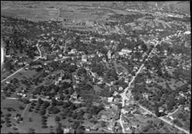
 Widnau from a bird's eye view |
|
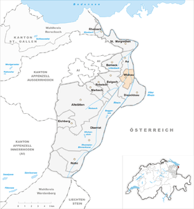
| Location of the municipality | |
  |
|
Widnau (in the eastern Swiss German local dialect Witnou [ˈʋitːnoːʊ] ) is a political municipality in the eastern Swiss canton of St. Gallen . It lies in the cultural landscape of the St. Gallen Rhine Valley and belongs to the Rheintal constituency .
geography
The political municipality of Widnau has a total area of 4.22 km², 59.4 percent of which is used as settlement area. 34.2 percent of the total area is used for agricultural purposes. The remaining 6.4 percent are wooded areas (forest and trees) and unproductive areas, including rivers and lakes. Widnau is located in the four-country corner on the western bank of the Rhine , which forms the border between the Austrian state of Vorarlberg and the Swiss canton of St. Gallen . Part of the town-like settlement of Heerbrugg also belongs to the municipality of Widnau. The Swiss neighboring communities of Widnau are Au SG in the north, Balgach in the west, Diepoldsau in the east and south; the neighboring Austrian municipality of Lustenau can be reached via the Rhine bridge at the Wiesenrain customs office. The Rhine Valley Inland Canal , a canal that runs parallel to the Rhine on the Swiss side, flows through the center of the municipality . Floods are the main geographic risk factor, as the events of 1999 and 2013 showed.
Area balance
In 2009, the Widnau community had a total of 421 ha of community space.
- Artificially created areas amount to 263 hectares.
- 100 hectares of paved land
- 51 ha building
- 6 hectares of bedding structures
- 68 hectares of lawn
- 16 hectares of trees on artificially created areas
- 22 hectares of mixed small structures.
- The grass and herb vegetation takes up 116 hectares.
- The area of the bush vegetation is 11 hectares. Thereof:
- 2 hectares of bushes
- 7 hectares of bushy land
- 2 hectares of permanent horticultural crops.
- The tree vegetation extends over 15 hectares.
- 2 hectares of closed trees
- 6 hectares of linear trees
- 7 hectares of trees.
- Water and wet areas extend over 13 hectares.
- 11 hectares of water
- 1 ha of wet sites
- 1 ha of reeds.
- The area without vegetation is 3 hectares.
climate
The climate in Widnau is mild, also thanks to the alpine foehn . As a result, palm trees and various tropical fruits such as kiwi , figs and sweet potatoes also thrive . The annual mean is around 10.5 ° Celsius.
population

The inhabitants of Widnau are called Widnouer .
Demographics
On January 1, 2020, Widnau had a population of 9,686 inhabitants, of whom 4,912 were male and 4,774 were female. 2616 people were local residents of Widnau and 2689 foreign nationals.
According to the 2012 municipal profile, of the four national languages in Switzerland, German is spoken the most frequently at 88 percent. In contrast, only 1.6 percent speak Italian, 0.3 percent French and 0.1 percent Romansh. The remaining 10 percent is spread across foreign languages.
The age structure of the resident population was distributed as follows on January 1, 2020: 20 percent were younger than 20 years, 25 percent between 21 and 40 years, 28 percent between 41 and 60 years and the remaining 19% were over 61 years old.
religion
As of January 1, 2020, 4,848 residents of Widnau were Roman Catholic. The second most common is the Protestant denomination with 1286 members. The remaining 3552 residents can be assigned to another religion or none of them.
The Catholic parish of Widnau, located in the diocese of St. Gallen , has been part of the Widnau-Balgach-Diepoldsau-Schmitter pastoral care unit since October 29, 2005, together with the Catholic parishes of Balgach and Diepoldsau-Schmitter. The Evangelical Reformed population belongs to the Diepoldsau-Widnau-Kriessern parish of the Evangelical Reformed Church of the Canton of St. Gallen .
politics


Widnau has been organized as a unified community since January 1st, 2001 .
Municipal council
| Köppel Christa (President) | Peter Weder (Vice President) | Werner Barmettler | Richard Dünser | Marco Koeppel | Stefan Sieber | Yvette Werner |
Mayor
In 1999 Christa Köppel succeeded the long-time Widnau mayor Hans Fehr. She was the first female mayor in the canton of St.Gallen. With her renewed re-election on September 25, 2016, she was confirmed for the fifth time for a further 4 years of office.
Other mayor presidents were
- Jakob Spirig (1883 to 1885)
- Ferdinand Wider (1885 to 1899)
- Clemens Köppel (1899 to 1900)
- Franz Frei (1900 to 1906)
- Clemens Köppel (1906 to 1912)
- Raimund Frei (1912 to 1919)
- Emilian Frei (1919 to 1927)
- Reimund Frei (1927 to 1936)
- Paul Wider (1936 to 1959)
- Hans Spirig (1959 to 1989)
- Hans Fehr (1989 to 1999)
Distribution of parties
| Political party | FDP | CVP | SP | SVP | BDP | EPP | GLP | GPS |
| Share of voters in percent | 12.1 | 23.2 | 12.6 | 37.1 | 2.9 | 0.9 | 5.6 | 4.3 |
Others

The police station for the Middle Rhine Valley is located in Widnau at the Metropolkreisel on Neugasse.
economy
Widnau is an important business location in the St. Gallen Rhine Valley. In 2017, Widnau had 696 companies and 5009 employees (of which 4124 full-time equivalents). 66 percent of the employees worked in the tertiary economic sector (service sector). In the secondary economic sector (industry) 33 percent of the employees were employed. In the course of the sale of industrial / commercial land by the Patronale Stiftung Viscosuisse, numerous companies were able to take the opportunity to settle in Widnau or to purchase additional commercial space.
Industry

The beginning of industrialization goes back to the advent of the hand embroidery machine around 1850. In 1879, 115 of them were already in use in Widnau. In 1897, the embroidery manufacturer Jacob Rohner built a factory in Widnau, and in 1905 Julius Bunke embroidery was added.
During the period of unemployment in 1924, the establishment of the artificial silk factory Société de la Viscose Suisse from Emmen LU - popularly known as Viscose - was a ray of hope not only for Widnau, but for the whole valley. The factory gave work and created new income opportunities - for the young men and also for many young women. The factory was the engine for the rapid economic, demographic and social development of the young community. In the 1970s, viscose employed a good 1,500 people. The railway connection built for the Viscose from Heerbrugg station to the industrial areas of Nöllen and Unterletten (formerly Viscose area ) is considered a stroke of luck. Because of her, well-known large companies are still settling in the 350,000 m² industrial park in Widnau, in one of the largest industrial parks in Eastern Switzerland.
traffic

Widnau is served by the bus route 303 of the RTB Rheintal Bus , which leads across borders to Hohenems in Austria . This company is the successor to the former Heerbrugg – Diepoldsau tram , which operated from 1915 to 1956. The municipality also offers e-bikes for rent. Motorized private transport and bicycles are the most popular means of transportation. Widnau has a very dense, modern network of roads and footpaths. The train station is not far from the municipal boundary in Heerbrugg.
Widnau can be reached via the A13 motorway junction and is around 19 km from Altenrhein Airport.
history
Naming
The first recorded name of the place - or that of a neighboring, later submerged place? - was Ibirinesouva . This is documented in a document from 891. The name means " Au des Eburin or Iburin".
The current name Widnau was mentioned for the first time in 1303 in a document from the St. Gallen monastery as Widenouwe , which originally meant "near the meadow with willows".
Middle Ages and Early Modern Times
The Rhine Valley was settled by the Alemanni from the 7th and 8th centuries . The Rhine plain was predominantly marshland, while the villages on the foothills of the foothills of the Alps and the Appenzell region were densely forested.
Widnau belonged to the Reichshof Lustenau for centuries . Although the entire valley area to the left of the Rhine came under the sovereignty of the federal places as a bailiwick in 1490, jurisdiction in the Rhine Valley remained diffuse, as the Counts of Hohenems still made claims to the low jurisdiction.
On January 6, 1593, Widnau-Haslach on the left bank of the Rhine (the area of today's communities Widnau, Schmitter and Au ) was divided off by Lustenau. On June 5, 1593, the first community meeting was held.
In 1775 the division into the three independent Rhoden Widnau, Schmitter and Au-Haslach followed.
1766–1776 came the Counts of Harrach. From 1782–1798, the von Salis-Soglio family owned not only the lower jurisdiction, but also the church patronage of Widnau until 1856.
Napoleon created new conditions in 1798 : he transferred the broken Confederation to the Helvetic Republic , and Widnau was integrated into the newly created canton of Säntis as part of the municipality of Diepoldsau .
19th century
The Helvetic project was characterized by civil war-like turmoil. For a second time, Napoleon forced the Confederation - again with military force - to issue a new constitution: the act of mediation. Six new cantons were added to the 13 cantons, including the canton of St. Gallen as it is today. In the course of the legislative work of the newly appointed Grand Council, the political communities were created in their modern form in 1803 and their tasks anchored in the constitution. Widnau thus became part of the political community of Diepoldsau. The 19th century was marked by (theoretical, political and very tangible) debates about the formation of political institutions in the course of the emergence of the modern state. The residents of Widnau did not seem to ignore this topic either: In 1879 they founded a so-called separation commission, which was to campaign for the separation of Diepoldsau and for political self-government by means of a petition to the government. 32 meetings, countless heated debates, tight votes and just as tight reconsiderations later - even the press was called in - the government council decided on May 1, 1882 to comply with the Widnauer's request for a political community of its own, after a number of preparations, such as the on-site inspection and marking the boundaries, the resolution became legally effective on July 1, 1883. Since then, no new municipality has been created in the canton of St. Gallen through territorial separation.
Like most communities in the Rhine Valley, Widnau was a poor community of small farmers. The population suffered from the annually repeated floods. The Rhine regularly stole the few cattle and the meager harvest from the "poor hawkers". When the community was founded in 1883, it was not only doubted whether there would be enough intelligence in Widnau to manage its own community successfully, but it was also assumed that the money was far from being enough. In the middle of the 19th century, individual smallholders started doing silk winding at home, then chain embroidery. The hand embroidery machine brought income opportunities to a greater extent. With the Schiffli embroidery machine and the technical development of the machine, the sideline became the main source of income. Widnau became the village of stickers. The thriving, export-oriented embroidery industry collapsed completely during the First World War . For many large families the need and poverty came back. This leads to a wave of emigration to America in the twenties.
20th century
The time after the Second World War brought an unexpected boom. New commercial and industrial companies settled here. Widnau changed from a poor farming village to a modern, progressive industrial community. The local population was very proactive and innovative economically. Numerous small “Büdeli” were founded in barns, extensions and garages, in which the whole family worked. In the sustained growth phase and the boom of the 1950s to 1970s, these small businesses developed into well-known companies, today with an international reputation and in many cases still owned by the founding families.
In 2005, plans for a merger of the municipalities of Au, Balgach, Berneck, Diepoldsau and Widnau to form the town of Heerbrugg were first taken up in 1930 . The new community would have had around 27,000 inhabitants. However, the bill was rejected on June 17, 2007 by the voters of all municipalities. One study identified fear of losing one's home as the main reason.
Art and culture
schools

Since moving into the new Schlatt school in 2016, all primary schools (Schlatt, Rüti and Wyden) as well as the upper school center Gässeli are located in the village center. The kindergartens are also located in the center and in the Girlen.
Events
The Kilbi, the Binnenfest and the Stangenfest take place in Widnau every year.
Attractions

Catholic Church of St. Joseph, built in 1904

Evangelical Chapel Widnau built in 1911

Crucifix of the Catholic parish church of St. James, consecrated in 1504
Freiraum formerly Restaurant Löwen
"Stoffel" development

In the middle of the village the Rheintaler inland canal


freetime and sports
The Aegeten sports facility in Widnau offers the following facilities:
- outdoor pool
- 3 soccer fields
- Light aletics
- Ice rink
- Multipurpose hall
- Tennis hall and outdoor courts
The Rhine Route , a well-known long-distance cycle path (Veloweg) along the Rhine, runs on the edge of Widnau .
The Mosanger nature reserve is located in the south of Widnau im Riet .
Personalities

- Gebhard Ammann (1901–1969)
- Martin Bickel (1938–2003), artist
- Leo Broder (1903–1983), art historian, teacher
- Ernst Menzi (1897–1984), entrepreneur, inventor of the walking excavator (Menzi Muck)
- Albert Wider (1910–1985), artist
literature
- Markus Kaiser: Widnau. In: Historical Lexicon of Switzerland .
- Otto Frei, Benedikt Fehr, Hans Fehr: Widnau - past and present . Ed .: Political community Widnau, local community Widnau. Rheintaler Druckerei und Verlag AG, Heerbrugg 1982, p. 288 .
- Konrad Sonderegger: The Rhine Valley around 1900 . tape 2 : 180 old postcards from Widnau, Diepoldsau-Schmitter, Rebstein, Marbach, Altstätten, Eichberg, Oberriet (with Kriessern, Montlingen and Kobelwald) and Rüthi . Appenzeller Verlag, Herisau 1990, p. 184 .
Web links
Individual evidence
- ↑ Permanent and non-permanent resident population by year, canton, district, municipality, population type and gender (permanent resident population). In: bfs. admin.ch . Federal Statistical Office (FSO), August 31, 2019, accessed on December 22, 2019 .
- ↑ a b Lexicon of Swiss municipality names . Edited by the Center de Dialectologie at the University of Neuchâtel under the direction of Andres Kristol. Frauenfeld / Lausanne 2005, p. 963.
- ↑ a b c regional portraits of the communities. (No longer available online.) Swiss Confederation, archived from the original on July 30, 2012 ; Retrieved November 21, 2013 .
- ^ Rheintaler inland canal, flood. Zweckverband Rheintaler Binnenkanal, accessed on November 21, 2013 .
- ↑ Land cover statistics: Land cover (NOLC04) by district and municipality, in hectares. Federal Statistical Office (FSO), accessed on January 7, 2020 .
- ^ STAT-TAB: The interactive statistics database, population development by region, 1850–2000. Swiss Confederation, accessed on January 10, 2014 .
- ↑ STAT-TAB: The interactive statistics database, population status. Swiss Confederation, accessed on October 16, 2019 .
- ↑ annual report of the municipality Widnau widnau.ch
- ↑ widnau.ch .
- ↑ Widnau in figures, statistics of the resident population as of January 1, 2020, accessed on February 17, 2020.
- ↑ widnau.ch .
- ↑ Municipal Council. Widnau community, accessed on January 7, 2020 .
- ↑ Handover of the office: Mayor Hans Fehr to Mayor Christa Köppel Article on tagblatt.ch from May 1, 1999.
- ↑ Widnau: A slightly different mayor article on observer.ch from July 5, 2002.
- ↑ Yvette Werner Hengartner new in the local council Article on rheintaler.ch from September 25, 2016.
- ↑ Otto Frei, Dr. Benedikt Fehr, Hans Fehr: Widnau - past and present . Ed .: Political community Widnau, local community Widnau. Rheintaler Druckerei und Verlag AG, Heerbrugg 1982, p. 56 .
- ↑ viscosuisse.ch
- ↑ a b Otto Frei, Dr. Benedikt Fehr, Hans Fehr: Widnau - past and present . Ed .: Political community Widnau, local community Widnau. Rheintaler Druckerei und Verlag AG, Heerbrugg 1982, The village of stickers, p. 148-163 .
- ↑ 100 years of thread magic. (PDF) Rodia Industrial Yarns AG, accessed November 30, 2013 .
- ↑ Portrait of the community of Widnau. Widnau community, accessed on November 30, 2013 .
- ↑ Widnau buys industrial land in the Viscose area. Widnau community, accessed on November 30, 2013 .
- ↑ a b Markus Kaiser: Widnau. In: Historical Lexicon of Switzerland .
- ↑ Thomas Arnold Hammer: The place and field names of the St. Gallen Rhine Valley. Name structure and settlement history (= Studia Linguistica Alemannica. Volume 2). Diss. Univ. Zurich. Huber, Frauenfeld / Stuttgart 1973, pp. 97 and 101; then a lexicon of Swiss community names . Edited by the Center de Dialectologie at the University of Neuchâtel under the direction of Andres Kristol. Frauenfeld / Lausanne 2005, p. 963.
- ^ Lorenz Hollenstein: Rhine Valley. In: Historical Lexicon of Switzerland .
- ^ Ludwig Welti: From the Carolingian royal court to the largest Austrian market town . In: Marktgemeinde Lustenau (ed.): Lustenauer Heimatbuch . I. Volume. Lustenau 1965, p. 86 f .
- ↑ Otto Frei, Dr. Benedikt Fehr, Hans Fehr: Widnau - past and present . Ed .: Political community Widnau, local community Widnau. Rheintaler Druckerei und Verlag AG, Heerbrugg 1982, first division of the court 1593, p. 26 .
- ↑ Otto Frei, Dr. Benedikt Fehr, Hans Fehr: Widnau - past and present . Ed .: Political community Widnau, local community Widnau. Rheintaler Druckerei und Verlag AG, Heerbrugg 1982, Second Division of the Court 1775, p. 38 .
- ↑ a b Otto Frei, Dr. Benedikt Fehr, Hans Fehr: Widnau - past and present . Ed .: Political community Widnau, local community Widnau. Rheintaler Druckerei und Verlag AG, Heerbrugg 1982, Das letzte Wegstück, p. 48-51 .
- ^ Community Widnau, history-growth phase. Widnau community, accessed on November 30, 2013 .
- ^ Project Vision "Heerbrugg Municipality", final report. Administrations of the municipalities of Au, Balgach, Berneck, Diepoldsau and Widnau, accessed on November 30, 2013 .
- ↑ Otto Frei, Dr. Benedikt Fehr, Hans Fehr: Widnau - past and present . Ed .: Political community Widnau, local community Widnau. Rheintaler Druckerei und Verlag AG, Heerbrugg 1982, p. 62 .
- ↑ Otto Frei, Dr. Benedikt Fehr, Hans Fehr: Widnau - past and present . Ed .: Political community Widnau, local community Widnau. Rheintaler Druckerei und Verlag AG, Heerbrugg 1982, p. 58 .
Remarks
- ↑ The areas are given by the Federal Statistical Office in hectares (ha).