
Thal SG
| SG is the abbreviation for the canton of St. Gallen in Switzerland and is used to avoid confusion with other entries of the name Thal . |
| Thal | |
|---|---|
 |
|
| State : |
|
| Canton : |
|
| Constituency : | Rorschach |
| BFS no. : | 3237 |
| Postal code : | 9423 Altenrhein 9422 Buechen 9425 Buriet 9422 Staad 9425 Thal |
| UN / LOCODE : | CH ATR (Altenrhein) CH THL (Thal) |
| Coordinates : | 760 632 / 259267 |
| Height : | 418 m above sea level M. |
| Height range : | 392–664 m above sea level M. |
| Area : | 9.66 km² |
| Residents: | 6571 (December 31, 2018) |
| Population density : | 680 inhabitants per km² |
| Website: | www.thal.ch |
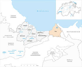
| Location of the municipality | |
  |
|
Thal is a municipality in the canton of St. Gallen . It consists of the localities Thal, Staad and Altenrhein.

geography
Geographical location


Thal and Buriet belong to the so-called inner Rhodes and Altenrhein , Buechen , Staad belong to the so-called outer Rhodes with the Buechberg (525 m) as a separation.
- Altenrhein is located at the mouth of the Old Rhine in Lake Constance .
- Buriet is located on the northeast slope of the Buechberg.
- Buechen lies between the Buechberg and the Rorschacher Berg , Staad forms a unit with Buechen and lies northwest of Buechen on Lake Constance.
- Thal is - as the name suggests - in a climatically protected valley basin between the Buechberg in the north and Lutzenberg in the south.
history
The history of the individual parts of the community is very different from one another. While Thal belonged to the Vogtei Rheintal until 1798 , Altenrhein and part of Staad were subordinate to the Prince Abbey of St. Gallen .
Thal
Thal was first mentioned in 1163 as curtis tale . The Bishop of Constance sold the in Thal, Buechen, Heiden , Lutzenberg , Rheineck , Staad and Wolfhalden existing farm valley along with the church in 1163 to Rudolf von Pfullendorf , of the 1209 converted into Reichsvogtei Rheineck Reichshof to Emperor Frederick I inherited. Niedergericht , Kirchsatz and Kelnhof Thal were pledged to the Lords of Sulzberg in 1341 . 1429 broke away Kurzenberg of Thal 1598 was a Allmend division between the Court and Thal Kurzenberg performed. In 1498 the town of Rheineck was definitively separated, and in 1770 an allmend division in the Buriet among the villagers. From 1490 to 1798, Thal was part of the Rheintal bailiff . From 1798 to 1803, Thal belonged to the Rheintal district in the canton of Säntis , then from 1803 to 1831 to the Rhine Valley district of St. Gallen and from 1831 to 2002 to the Lower Rhine Valley district .
The first church is believed to have been built around 700. The parish of Thal with the Church of Our Lady comprised Thal, Buechen, Staad, Rheineck, the Appenzell communities of Heiden, Lutzenberg and Wolfhalden and, until 1791, the Austrian Gaissau . From 1529 to 1532 Thal was reformed, then equal. In 1712 the church property was divided. In 1716 the reformed parish Thal-Lutzenberg was established, in 1790 the reformed church Buechen-Staad was built.
From the 16th century onwards, castles and country houses were built here for nobles and citizens of the city of St.Gallen . The Rhine and the streams from the Appenzell foreland caused damage again and again. Between 1889 and 1897 the building was built. A fire destroyed 49 buildings in 1806.
Until the Second World War, Thal lived mainly from agriculture, before 1850 BC. a. from agriculture with 12 mills. Sandstone has also been extracted since the late Middle Ages . Viticulture on the Buchberg is documented as early as the 10th century. In 1886 the vineyard area was 96 ha, in 1992 it was still 20 ha. In 1916, the Thal wine cooperative was founded. Next to it, industry settled down early: in 1813 a twisting mill , in 1891 a dye works, in 1836 a silk gauze factory Sefar with factory and home work and in 1862 a cardboard factory. The former foreign hospital from 1885 was converted into a community hospital in 1916 and a regional nursing home in 1979). From 1930 to 2012 the Steyler missionaries ran the Marienburg grammar school . Thanks to the connection to the autobahn in 1973, various industrial and commercial enterprises v. a. settled in the Buriet, while in Buechen residential quarters, school and leisure facilities are concentrated.
Altenrhein and Staad
→ see section history in the article Altenrhein SG
→ see section history in the article Staad SG
coat of arms
Description: In silver, a blue grapevine with green leaves.
Population development

| Population development | |
|---|---|
| year | Residents |
| 1850 | 2748 |
| 1900 | 3546 |
| 1950 | 4025 |
| 1980 | 4725 |
| 2000 | 5996 |
| 2010 | 6286 |
religion
There is a parity church in Thal, a Roman Catholic church in Staad and Altenrhein, and a Protestant church in Buechen / Staad.
politics
The municipal administration has its seat in Thal.
Culture and sights

Buildings
- With the five-part bronze bell of the Egger bell foundry a 0 - c 1 - d 1 - f 1 - a 1, the parity church of Thal has a bell ensemble that is unique in Switzerland.
- The Roman Catholic Christ the King Church, built in 1967, stands on a hill near Staad .
- Other striking buildings are the Blatten, Greifenstein and Risegg castles in the Buechen district.
- The Hundertwasser market hall , built between 1998 and 2002, is located at the roundabout between Staad and Altenrhein.
Museums
- At the airfield in Altenrhein there is an aviation museum with airplanes from the 1940s to 1980s that are kept in an airworthy condition.
Economy and Infrastructure
Established businesses
Altenrhein
Altenrhein changed from a fishing village to an industrial settlement in 1924 with the establishment of a branch of the Dornier works . The Flug- und Fahrzeugwerke Altenrhein (FFA) developed from the Dornier works after the Second World War . From 1987 the FFA was gradually sold and split up into Stadler Rail (Altenrhein) and other operations.
→ see section Economy in the article Altenrhein SG
Thal and Staad
The world's largest manufacturer of shopping trolleys , Wanzl , has had a branch in Thal since 1972.
The Egger bell foundry existed in the Staad district until 1940 and was responsible for numerous church bells in eastern Switzerland.
traffic
The St. Gallen-Altenrhein airfield (ACH) developed from the former works airfield of the aircraft factory . This was opened for scheduled air traffic in 1988 with a connection to Vienna and has since been expanded. Since 2003 it has been called St. Gallen-Altenrhein Airport . In 1998 the International Bodensee Airshow took place in Altenrhein .
In Buriet there is a connection to the A1 motorway . There is also a base for the motorway police and a maintenance service depot for the motorway. The cantonal road traffic and shipping office operates a test center in Buriet.
The villages of the political municipality of Thal are connected by PostBus lines. These also provide a connection to the SBB in the Staad and Rheineck stations .
education
In Thal is the OZ Thal, where students from all three communities (Thal, Staad, Altenrhein) graduate from 7th to 9th. Complete class.
Personalities
- Lukas Christ (1881–1958), Protestant clergyman in Pratteln
- Jessica Lutz (* 1989), American-Swiss ice hockey player
- Jolanda Neff (* 1993), racing cyclist (mountain bike), lives in Thal.
Web links
Individual evidence
- ↑ Permanent and non-permanent resident population by year, canton, district, municipality, population type and gender (permanent resident population). In: bfs. admin.ch . Federal Statistical Office (FSO), August 31, 2019, accessed on December 22, 2019 .
- ↑ Buechen-Staad. On the website of the municipality of Thal, accessed on November 1, 2019
-
^ Peter Müller: Thal (SG). In: Historical Lexicon of Switzerland .
These sections are largely based on the entry in the Historical Lexicon of Switzerland (HLS), which, according to the HLS's usage information, is under the Creative Commons license - Attribution - Share under the same conditions 4.0 International (CC BY-SA 4.0).