
Oberriet
| Oberriet | |
|---|---|
 |
|
| State : |
|
| Canton : |
|
| Constituency : | Rhine Valley |
| BFS no. : | 3254 |
| Postal code : | 9451 Kriessern 9462 Montlingen 9463 Eichenwies 9463 Kobelwald 9463 Oberriet |
| UN / LOCODE : | CH LOCATION (Oberriet) CH KSN (Kriessern) CH MNG (Montlingen) |
| Coordinates : | 760 642 / 243042 |
| Height : | 420 m above sea level M. |
| Height range : | 404-1305 m above sea level M. |
| Area : | 34.60 km² |
| Residents: | 8879 (December 31, 2018) |
| Population density : | 257 inhabitants per km² |
| Website: | www.oberriet.ch |
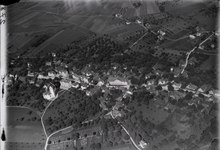
 View of Oberriet |
|
| Location of the municipality | |
  |
|
Oberriet is a municipality in the cultural landscape of the St. Gallen Rhine Valley in the canton of St. Gallen in eastern Switzerland . Politically, Oberriet belongs to the Rheintal constituency .
geography
Bounded by the Alpine Rhine in the east and the foothills of the Alpstein Mountains in the west, the municipality of Oberriet lies in the heart of the St. Gallen Rhine Valley on the border with Austria ( Vorarlberg ). With its 34.5 square kilometers, it is one of the larger communities in the canton of St. Gallen. In addition to the core settlement, the political community also includes the villages of Montlingen , Kriessern , Eichenwies and Kobelwald as well as the hamlets of Moos, Rehag, Stieg, Freienbach, Stein, Kobelwies, Watt and Hard. The highest point in Oberriet is in the Zapfen area at 1302 m above sea level. M. . The lowest point is 407 m above sea level. M. at the 3 bridges (alem. Dreibruggen ) over the Rheintaler inland canal on the connecting road between Balgach and Diepoldsau .
Oberriet also owns a special piece of land: Alp Sämtis in the canton of Appenzell Innerrhoden , near Brülisau . It is owned by the local community of Allgemeine Hof Oberriet , but is not located in the community area. This alp is called the most beautiful in the Alpstein and there have been quite a few arguments because the Appenzell wanted to get this alp back. The alp has belonged to the municipality of Oberriet or Reichshof Kriessern since the Middle Ages.
Between the villages there are various nature reserves with a great wealth of plant and animal species.
The municipal area is 3456 ha , of which 292.2 ha is a building zone. 234.7 hectares of which were largely built over.
population
As of December 31, 2019, the municipality of Oberriet had a total of 8,917 inhabitants. Separated by sex, there are 4588 male and 4329 female residents. 5872 inhabitants are Catholic, 977 Reformed and 2068 belong to another or no denomination.
In the municipality of Oberriet there lived 4561 local citizens , 1518 canton citizens and 1276 citizens of the rest of Switzerland. Oberriet hosted 1562 foreign nationals.
On December 31, 2010 the village of Oberriet had 2,711 inhabitants. That corresponds to 33% of the population of the political municipality Oberriet.
| Population development | ||||||
|---|---|---|---|---|---|---|
| year | 1798 | 1850 | 1900 | 1950 | 2000 | 2010 |
| population | 2598 | 3909 | 4277 | 5582 | 7454 | 8314 |
politics

The municipality of Oberriet consists of the 5 villages Oberriet, Montlingen, Kriessern, Eichenwies and Kobelwald (see also above). Each village is organized in a local church. Thus, the municipality of Oberriet has 5 local churches, one might think. But it has 6. Because the remnant of the Reichshof Kriessern remained the local parish “General Hof Oberriet”. All citizens of a local community in the political community of Oberriet are automatically also court citizens. So this is like an umbrella organization for all local churches.
The general yard is primarily responsible for forestry in the local communities and has its own work yard for this. Since Diepoldsau also has forests, which the "Allgemeine Hof" looks after, the local community of Diepoldsau is also a member of the farm. The farm has 6 local parishes, but the political municipality of Oberriet only has 5.
economy
Oberriet is characterized by a large area for agriculture and forestry. Thanks to the Rhine regulation at the beginning of the 20th century and the simultaneous amelioration , the agricultural area in the plain could be better used. The so-called settlements in the Riet emerged.
In addition to various small and medium-sized businesses, there are three larger industrial sites in the area of the political community; north of Montlingen (Letzau), north of Eichenwies and east of the village of Oberriet. These three areas are each dominated by a larger company. In Oberriet Ost it is the steel and plastic pipe producer Jansen AG , which with around 700 jobs is clearly the largest employer in the municipality of Oberriet. In the Eichenwieser industry, the company Rino Weder AG stands out, which produces windows, doors and facades, partly from products from the aforementioned Jansen AG. The Letzau industrial area in Montlingen is dominated by buildings belonging to Bezema AG, which is a supplier for textile producers. Among other things, the company produces textile dyes.
traffic
The community between Buchs SG and Altstätten is connected to the A13 motorway in Oberriet and Kriessern . In addition, there are 3 border crossings to Austria in the municipality, namely one each in Oberriet, Montlingen and Kriessern. In addition, there is a direct feeder to Appenzell and Egger in Oberriet, the Waldstrasse. However, this is mainly used by locals, as it is not so well known and is only a relatively narrow gravel road on Appenzell soil.
Public transport
Oberriet does have a train station, but due to a lack of regios , almost no trains stopped at the train station between the turn of the millennium and the end of 2013. It is connected by a bus line between Altstätten and Buchs SG. In December 2013 there was an expansion of public transport in the canton of St. Gallen, which mainly included a ring S-Bahn around the entire canton. The Oberriet station was reactivated in the course of this service improvement and today one train in each direction stops at the station every hour. The bus line over the Eichberg was discontinued, but the one over Montlingen / Kriessern to Kobelwald was extended. In the area of the Oberriets train station, a bus station for four buses was built, while Oberriet became a train / bus transfer point. There has also been a bus connection to Rankweil since December 2014. A few cornerstones of the station extension: An underpass was built on the other side of the tracks, which means that the sports facilities in the Bildstöckli can be reached more quickly. In addition, the two platforms and the edges of the bus stops were roofed. The goods shed was demolished and numerous bicycle and car parking opportunities arose (a plan of the extensions planned at the time is available in the following link).
history
The historical roots of the community begin over 3000 years ago on the Montlingerbergli (Monticulus). At that time the Inselberg offered protection from the floods of the Rhine to the Ur-Räts who immigrated from the south. This prehistoric settlement is on the list of cultural assets of national importance . They were later ousted by the Alemanni who moved up from the north. In addition to many customs and traditions, these brought German as a mother tongue to the Oberriet area. Even today the traditional dialects in the Rhine Valley are reminiscent of these ancestors.


The royal court of Criesserrun was established in the 8th century . The construction of a church in Montlingen in the 9th century resulted in two centers in the courtyard: the secular administration in Kriessern and the ecclesiastical center in Montlingen.
In 1229 the German king donated the farm to the St. Gallen monastery and Abbot Berchthold von Falkenstein had Blatten Castle built to defend the property . The fortified tower, the only remains of this castle, is the landmark of Oberriet today and greets all travelers from the top of the Blattenberg who are approaching the village from the Oberriet motorway exit or from customs. The castle ruins are known to the population as 'Schloss Blatten'.

Another castle ruin, the cave castle Wichenstein, also an object on the list of cultural assets of national importance, is located in a rock face on Semelenberg, below Kobelwald.
From 1490 to 1798 the entire left bank of the Rhine between Bad Ragaz and Rheineck was subject to the Confederates.
With the French Revolution in 1798, the Swiss Rheintaler received full independence from the Swiss Federal Diet. But the farm belonged to the Republic of the Rhine Valley only for a short time. For five years, the French occupied him forced the canton of Säntis, whose border against the canton of Linth ran across the Blattenberg. The political municipality of Oberriet emerged from the free Reichshof Kriessern in 1803.
The five villages developed within the parish boundaries and eventually each received its own church. As everywhere in the Rhine Valley, the main line of business here was agriculture. Later on, embroidery became more and more important. The community only slowly developed into an industrial location after the Second World War.
In the early days of the modern Oberriet community (early 19th century) the church was divided into various local churches and the school into various local schools. In 2008 and 2009, however, some schools were merged again for financial reasons and the Catholic parishes merged with the Rüthi-Lienz parish in March 2009 for personal reasons to form the Blattenberg pastoral care unit.
Archaeological sites
There are two important archaeological sites in the municipality of Oberriet.
- The prehistoric hilltop settlement on the Montlingerberg can be visited, but not very much can be seen, as the excavation sites are under agricultural land. Only a look from the audience platform at the former earth wall gives an idea of the size of the facility.
- The site of the Abri Unterkobel discovered in 2011 is on the site of a private landfill and cannot be visited. The part of the excavation site that was not recovered has since been covered up again.
Art and culture
Attractions
- Blatten Castle ruins
- Ruin of the cave castle Wichenstein
- Kobelwald crystal cave
- Municipal museum «Rothus»
Others
In 2005 and 2006 the main street in Oberriet, which runs through the middle of the village, was completely renovated. Various works to refresh the townscape were also done in the course of this measure. So all large forecourts were laid out with setting stones, modern bus shelters and new street lamps were put up.
In older editions of the Swiss School Atlas, Oberriet was shown as an example of a typical street village. The farms and restaurants were on the main road with the associated lands on the back. Until 1975, Oberriet also had an enclosed and representative square, the so-called Postplatz with its classicist buildings such as the “Rössli” inn, the Konkordia, the post office and a few other residential buildings. This place played an important role in the road lines of earlier times (including Arlberg-Switzerland) when loading goods, during overnight stays and at events for the population. Directly behind the Postplatz was the old parish office in today's “Rothus & # 157;”. The importance of the former Postplatz is expressed in the fact that in the 19th century the new train station was not built near the church, but near the Postplatz.
In the municipality of Oberriet there are many clubs with active club members. So it is in the community z. B. two NLA wrestling clubs, a football club, a pontoon driving club or youth clubs (e.g. Jungwacht and Blauring). A special feature is that there are also 5 gymnastics clubs in the community. One of them in Montlingen and two each in Oberriet and Kriessern. In the latter there is a KTV and an STV . These come from the parties before the federal foundation, on the one hand the conservatives, on the other hand the liberals. The KTV was the gymnastics club of the Catholic Conservatives and the STV (or earlier ETV) the club of the Liberals. Today the clubs are open to everyone.
Personalities
- Dionys Mattlin (1640-1700) was from 1679 to 1680 librarian at the St. Gallen monastery
- Gallus Alt (1610–1687) was as Gallus II from 1654 to 1687 Prince Abbot of St. Gallen
- Josef Jansen (born January 27, 1894 - † May 2, 1984), entrepreneur
- Guido Kolb (1928–2007), Catholic pastor and author
- René Savary (* 1949), racing cyclist
literature
- Konrad Sonderegger: The Rhine Valley around 1900 . tape 2 . Appenzeller Verlag, Herisau 1990, ISBN 3-85882-266-3 , p. 184 .
Web links
- Official website of the municipality of Oberriet
- Regula-Anna Steinhauser-Zimmermann: Blatten (SG). In: Historical Lexicon of Switzerland .
- Markus Kaiser: Kriessern. In: Historical Lexicon of Switzerland .
- Markus Kaiser: Montlingen. In: Historical Lexicon of Switzerland .
- Markus Kaiser: Oberriet (SG). In: Historical Lexicon of Switzerland .
Individual evidence
- ↑ Permanent and non-permanent resident population by year, canton, district, municipality, population type and gender (permanent resident population). In: bfs. admin.ch . Federal Statistical Office (FSO), August 31, 2019, accessed on December 22, 2019 .
- ↑ Local community of General Hof Oberriet: History of Alp Sämtis
- ↑ St. Galler Tagblat: Der Sutterhandel , August 22, 2008
- ^ Website of the municipality of Oberriet . Retrieved February 26, 2011.
- ↑ Plan of the Oberriet station area 2013 (PDF file; 3.49 MB)
- ^ Political community Oberriet: Historisches
- ^ Association directory of the municipality of Oberriet