Kobelwald
| Kobelwald | ||
|---|---|---|
| State : |
|
|
| Canton : |
|
|
| Constituency : | Rheintal constituency | |
| Political community : | Oberriet | |
| Postal code : | 9463 | |
| Coordinates : | 759 380 / 243 021 | |
| Height : | 518 m above sea level M. | |
| Residents: | 521 (December 31, 2009) | |
| Website: | www.kobelwald.ch | |
| map | ||
|
|
||
Kobelwald is a village in the Rheintal constituency of the canton of St. Gallen which belongs to the political municipality of Oberriet .
geography
About 100 meters above the Rhine plain, at the foot of a foothill of the Alpstein Mountains , Kobelwald lies like on a terrace in the St. Gallen Rhine Valley .
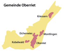
In addition to Kriessern , Montlingen , Eichenwies and the village of Oberriet, as well as the hamlets of Moos, Rehag, Stieg, Freienbach, Stein, Kobelwies, Watt and Hard, Kobelwald belongs to the political municipality of Oberriet . In the area of the municipality of Oberriet, the former Reichshof Kriessern, there are five different local parishes, which are grouped together in the local parish of General Hof Oberriet. The local communities Kriessern, Montlingen, Eichenwies and Oberriet are congruent with the respective villages.
Together with the hamlets of Moos, Rehag, Freienbach, Stein, Kobelwies, Watt, Hard and Hub (Hub is politically part of the Altstätten municipality ), Kobelwald forms the local community of Holz rhode and thus covers an area that extends far beyond the actual village. With the village church, the multi-purpose building and the primary school with the kindergarten, Kobelwald forms the center of this local community.

population
As of December 31, 2009, the village of Kobelwald had 521 inhabitants. The local community of Holzrhode has around 700 local residents. Part of the citizenry lives in the villages of Eichenwies and Oberriet.
history
Attractions
In the hamlet of Freienbach, a little above Kobelwald, you will find the Maria Visitation Chapel. Today's chapel was built in 1971 and replaced a pilgrimage chapel from 1740. As a Marian pilgrimage site, it attracts some pilgrims, especially in the month of May.
The crystal cave , which can be reached on foot in about 15 minutes from the village of Kobelwald , is known beyond the Rhine Valley .
Below the village, embedded in a rock face of the Semelenberg, are the remains of a former robber baron's castle, the Wichenstein ruins. It can only be reached via a steep footpath behind the Wichensteiner lake, a former "digger hole" in which clay was mined in the last century.
literature
- Konrad Sonderegger: The Rhine Valley around 1900 . tape 2 . Weber, Heiden 1990, p. 184 .
Web links
Individual evidence
- ^ Website of the municipality of Oberriet. Retrieved January 26, 2011
- ↑ PfarreiForum 09/2009 page 7 (www.pfarreiforum.ch)


