Alpstein
| Alpstein | ||
|---|---|---|
|
South view of the Alpstein massif |
||
| Highest peak | Säntis ( 2501.9 m above sea level ) | |
| location |
|
|
| part of | Appenzell Alps | |
|
|
||
| Coordinates | 744 178 / 234889 | |
|
Main part of the Alpstein massif in winter, seen from the Sellamatt (south) |
||
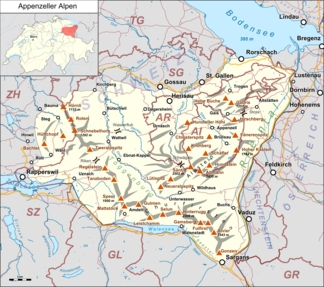
The Alpstein is a subgroup of the Appenzell Alps and belongs to the Swiss cantons of Appenzell Innerrhoden , Appenzell Ausserrhoden and St. Gallen .

Despite its rather low altitude compared to other Alpine peaks - the highest mountain is the Säntis at 2501.9 m - the Alpstein appears very powerful due to its northern «outpost position» with only a short distance to Lake Constance (just under 30 km as the crow flies).
shape
Geologically, the Alpstein, unlike the predominantly granite central Alps, is a limestone massif and thus represents a kind of western continuation of the northern limestone Alps that run further east between Germany and Austria . The limestone is interspersed with numerous cracks, caves and sinkholes . The water that drains off as a result leads to a water shortage, which some huts and Alps have to compensate for by collecting rainwater.
From a morphological point of view, the tectonic folds have essentially formed three ridges running from southwest to northeast, at the Saxer Lücke, shifted against each other by the Sax-Schwende break . They end in the east with Ebenalp , Alp Sigel and Kamor . Only the Lisengrat , the connection between the two peaks Altmann and Säntis, runs across the main ridges. Between these mountain ranges, on the Appenzell side, there are small mountain lakes embedded in the valleys of the Alpstein: Seealpsee , Sämtisersee and Fälensee . Two of the three lakes have no surface drainage; the water of the Falen and Samtisersee flows through the south-east upstream ridge into the Rhine . The easternmost ridge of the Alpstein slopes steeply towards the Rhine valley.
In western Alpstein, only the northern and middle Alpstein chain are formed up to the breakthrough of the Thur near Starkenbach , with the ridge line in the latter being significantly lower (highest point: Spisslen at 1,439 m above sea level). In between extends the Gräppelental with the Gräppelensee and the valley of Hintergräppelen.
The mountain range is rather steep and the valleys are deeply cut. The Alpstein is an ideal, partly demanding hiking area. In winter, especially between February and April, the experienced ski or snowboard can ski down from the Säntis massif down to Appenzell , Wasserauen or Brülisau or to Toggenburg to Unterwasser or Wildhaus .
climate
The climate in the Alpstein is characterized by its location on the northern edge of the Alps and the pronounced relief. In the Alpstein, for example, there is more than 1500 mm of precipitation per year, in pronounced storage areas (Schwägalp) and in the high areas (Säntis) well over 2500 mm of precipitation. In 1922 there was even 4173 mm of annual precipitation on the Säntis, and in April 1999 the highest total snow depth ever measured in Switzerland was recorded here at 816 cm.
In general, the temperatures decrease with increasing altitude; The annual mean temperature in Ebnat-Kappel (623 m above sea level) is 7.7 ° C, on the Säntis (2502 m above sea level) −1.2 ° C. In the depressions formed by karst processes without above-ground runoff ( Sämtisersee , Fälensee , Hintergräppelen, Furgglen) there are significant deviations from this rule under favorable weather conditions (dry and cold air, freshly fallen snow, clear sky, calm) and strong inversions develop . The temperature in these cold air lakes can drop by more than 25 degrees below the temperature that prevails at the same height in the free atmosphere. Minimum temperatures of below −30 ° C have already been measured both at the Sämtisersee and in the depression on Alp Hintergräppelen, in Hintergräppelen on January 7, 2017, the lowest temperature of this year in Switzerland was registered at −38.2 ° C.
|
Average monthly temperatures and precipitation for Säntis
53.25N / 9.34E 2502 m above sea level. M.
Source: MeteoSwiss
|
||||||||||||||||||||||||||||||||||||||||||||||||||||||||||||||||||||||||||||||||||||||||||||||||||||||||||||||||||||||||||||||||||||||||||||||||||||||||||||||||||||||||||||||||||||||||||||||||||||||||||||||||||||||||||||||||||||||||||||||||
summit
The highest peak is the Säntis ( 2502 m ), which can be reached with the mountain railway from the Schwägalp . The second highest elevation after the Säntis is the Altmann ( 2435 m ), the third highest is the Wildhauser Schafberg ( 2373 m ). Other striking points are the Staubernkanzel , the Hohe Kasten and the Ebenalp , all three of which are accessible by cable cars.
The Kronberg (also with cable car) and the Hundwiler Höhi , both Nagelfluhberge , no longer belong to the Alpstein, but already to the Appenzell foreland.
photos
High box ( 1795 m )
Meglisalp and Seealpsee
Berggasthaus Rotsteinpass with Lisengrat and Säntis in the background
Individual evidence
- ^ Oskar Keller: The Alpstein: Nature and culture in the Säntis area . Ed .: Hans Büchler. Revised u. added edition Appenzeller Verlag, Herisau 2014, ISBN 978-3-85882-700-5 ( verlagshaus-schwellbrunn.ch [PDF; accessed on 23 August 2018]).
- ↑ Normal values 1981–2010: total precipitation. (PDF) Federal Office for Meteorology and Climatology MeteoSwiss, accessed on 23 August 2018 .
- ↑ Records and extremes. Federal Office for Meteorology and Climatology MeteoSwiss, accessed on 23 August 2018 .
- ↑ Standard values 1981-2010: air temperature 2m. (PDF) Federal Office for Meteorology and Climatology MeteoSwiss, accessed on 23 August 2018 .
- ↑ Switzerland's lowest temperatures in winter 2016/17 measured in the Alpstein. In: Cold air lakes in Switzerland. Kaltluftseen.ch, accessed on August 23, 2018 .


