Kamor
| Kamor | ||
|---|---|---|
|
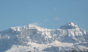
Kamor left and Hoher Kasten seen from Appenzell |
||
| height | 1751 m above sea level M. | |
| location | Cantonal border St. Gallen / Appenzell Innerrhoden , Switzerland | |
| Mountains | Appenzell Alps | |
| Dominance | 0.6 km → northern flank of the Hohe Kasten | |
| Notch height | 73 m ↓ Kastensattel ( 1678 m above sea level ) | |
| Coordinates | 754 908 / 239669 | |
|
|
||
The Kamor is a mountain between the St. Gallen Rhine Valley and Appenzell Innerrhoden in Switzerland and lies at an altitude of 1751 m above sea level. M. The name comes from the Romanic language: ganda mora , black Gand (scree slope , rock) became Gantmor as early as 1361 and from it today's Kamor (with an emphasis on the second syllable, in the dialect [kxaˈmoːr]).
Geography and nature
Less than a kilometer south of the Kamor is the summit of the Hohen Kasten at 1794 m above sea level. M. , this is accessible with a cable car . Kamor and Hoher Kasten are connected via the box saddle with a height of 1678 m above sea level. M. This means that the notch height is 73 m.
The last lamb vulture in the Alpstein was spotted on the Kamorwand in 1833 .
tourism
As early as the beginning of the 19th century, the ascent of Kamor and Hohem Kasten was described in alpine literature:
“From Gaiß, you often climb Alp Kamor and Hohenkasten, which I want to mention here, although Unterkamor belongs to Altstätten in the Rhine Valley, and Oberkamor and Kasten belongs to Lienz in the former Saxon dominion. From Gaiß, next to Fähnern, one is in four little hours at the herdsmen's huts of the Kamor, and in five hours on the back of the Hohenkastens. "
The Kamor is a bike and hiking mountain. From Kobelwald and Rüthi leads over the Montlinger sponge to about 1100 m above sea level. M. up a narrow, practically completely asphalted road that was laid out for military purposes (partly underground structures below the summit).
A simple, wooden summit cross stands on the camera .
The Kamor is also the namesake of the Kamor section of the Swiss Alpine Club .
Web links
Individual evidence
- ↑ a b c d e Kompass hiking map 112. Appenzellerland · St. Gallen · Säntis . Scale 1:50 000. Hallwag Kümmerly + Frey, Schönbühl, ISBN 978-3-85491-461-7 .
- Jump up ↑ Johannes Hoops, Heinrich Beck, Heiko Steuer: Reallexikon der Germanischen Altertumskunde, Volume 10, p. 608
- ^ Helmut Dummler: Appenzeller Land . The most beautiful valley and mountain hikes. 50 tours. 6th edition. Bergverlag Rother, Munich 2008, ISBN 978-3-7633-4086-6 , p. 109 .
- ↑ Johann Rudolf Steinmüller: Description of the Swiss Alpine and Agriculture . according to the various deviations of individual cantons: along with a brief display of the peculiarities of these Alps. Which contains the alpine and agriculture of the canton Appenzell and the St. Gallen districts Rheintal, Sax and Werdenberg. Steiner, 1802, p. 228 ( limited preview in Google Book search).
- ↑ A radio reception system is being built in Eastern Switzerland: EMD is building in a landscape worthy of protection. Freiburger Nachrichten, August 16, 1988, p. 20.
- ^ SAC Section Kamor


