Hoher Kasten (Appenzell Alps)
| High chest | ||
|---|---|---|
|
High chest |
||
| height | 1793 m above sea level M. | |
| location | Limit AI SG , CH |
|
| Mountains | Alpstein , Appenzell Alps | |
| Dominance | 3.5 km → Dustern pulpit | |
| Notch height | 204 m ↓ ridge to the Dustern pulpit | |
| Coordinates | 754 799 / 239018 | |
|
|
||
| Development | since 1964 by cable car | |
|
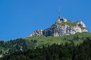
Summit area of the Hohe Kasten with cable car station, revolving restaurant and transmission tower (May 2008). |
||
|
View from Brülisau to Hohen Kasten (center) and Kamor (left). In the foreground the masts of the cable car. |
||
The high box is 1793 m above sea level. M. high mountain in the Alpstein of the Appenzell Alps and lies on the canton border between St. Gallen and Appenzell Innerrhoden in Switzerland .
In the local dialect the mountain is called de Chaschte [də ˈxaʃtə]. In the first mention of 1460 it says "on the box".
geography
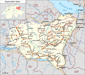
The municipalities of Altstätten and Rüte have a share , the municipality of Sennwald extends below the summit structure. Located above the St. Gallen Rhine Valley , the Hohe Kasten is the gateway to the Swiss Alps . The Hohe Kasten is also known as the « Rigi of Eastern Switzerland».
About 0.7 km as the crow flies north of the Hohen Kasten is the summit of the Kamor at 1751 m above sea level. The Kamor and Hoher Kasten are connected via the box saddle with a height of 1677 m above sea level. M. Approximately 3.5 km south-west lies the 1,860 m above sea level. M. high Staubern pulpit , which is connected to the Hohe Kasten via a mountain ridge . The lowest point of this ridge is 1590 m above sea level. M. The notch height is therefore 204 m. The distance to the pulpit also represents the dominance of the high box.
Economic and tourist use
The striking mountain peak has been accessed from the Appenzell side with a cable car since 1964 . It takes eight minutes to overcome the 871 m difference in altitude from Brülisau .
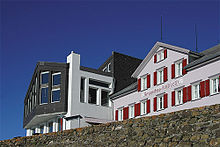
In May 2008 a revolving restaurant was opened on the mountain top.
A 72 meter high transmission tower of the telecommunications company Swisscom is located on the Hohen Kasten . It was built in 1999 and replaced a smaller transmission mast.
Since July 8, 2020, the SRF programs have been broadcast via DVB-T again. The company Kabel-TV Lampert GmbH & Co KG from Rankweil in neighboring Vorarlberg was responsible for the reactivation.
| channel | program | power | radiation |
|---|---|---|---|
| 34 | SRF 1 | 1.7 kW | D (310) |
| 34 | SRF two | 1.7 kW | D (310) |
From the high box, the radio station Radio FM1 broadcasts on the VHF frequency 103.2 MHz., The radio programs of SRF 1 SG on 104.8 MHz, SRF 2 Kultur on 97.7 MHz and SRF 3 107.4 MHz.
The box saddle is a popular starting point for paragliders , partly because it is accessible by cable car .
Historical
As early as the beginning of the 19th century, the ascent of Hohem Kasten and Kamor was described in alpine literature:
“From Gaiß you very often climb Alp Kamor and Hohenkasten, which I want to mention here, although Unterkamor belongs to Altstätten in the Rhine Valley, and Oberkamor and Kasten belongs to Lienz in the former rule of Sas. From Gaiß, next to Fähnern, one is in four little hours at the herdsmen's huts of the Kamor, and in five hours on the back of the Hohenkastens. "
hikes
The Hohe Kasten is located in the hiking area of the Alpstein .
- A more demanding high-altitude hike leads over the 1st geological hiking trail in Switzerland: With the cable car from Brülisau to the Hohe Kasten. The start is at the revolving restaurant Hoher Kasten. 14 display boards explain the geological phenomena of the Alpstein. The path leads from the Hohe Kasten over a ridge to the Staubernkanzel . This is where the Stauberen mountain inn and the mountain station of the Frümsen-Stauberen cable car are located. The valley station is in Frümsen in the St. Gallen Rhine Valley . The path continues to the Saxer Lücke and the Bollenwees mountain inn, which is located on the wild and romantic Fälensee . The descent leads back to Brülisau at the Sämtisersee and the Gasthaus Plattenbödeli. The walking time is approx. 5½ hours, dangerous places are secured by wire ropes. However, surefootedness is a prerequisite.
- A family-friendly hiking trail leads from Brülisau via Eggli, the Forstseeli and the Kamor to the Hohen Kasten. The walking time is approx. 4½ hours.
- Another hike goes from Rüthi in the St. Gallen Rhine Valley over the Brunnenberg and the Inneralp to the Hohen Kasten. The walking time is approx. 4 hours.
- Another hike is on the north side. By car from Kobelwies (municipality of Oberriet ) in the St. Gallen Rhine Valley to the Montlinger Schwamm ( 1100 m ), continue on foot over the Resspass to the Kamorsattel and then to both peaks ( Kamor and Hoher Kasten ). The walking time is 2½ hours.
Individual evidence
- ↑ a b c > SwissTopo (maps of Switzerland)
- ↑ S. Sonderegger: The place and field names of the Land of Appenzell, Vol. I: 3, Frauenfeld 1958
- ^ Helmut Dummler: Appenzeller Land . The most beautiful valley and mountain hikes. 50 tours. 6th edition. Bergverlag Rother, Munich 2008, ISBN 978-3-7633-4086-6 , p. 11, 108 .
- ↑ a b c Kompass hiking map 112. Appenzellerland · St. Gallen · Säntis . Scale 1:50,000. Hallwag Kümmerly + Frey, Schönbühl, ISBN 978-3-85491-461-7 .
- ↑ Radio FM1 now also broadcasts from Hohen Kasten ( memento from August 22, 2016 in the Internet Archive ) Tagblatt Online : September 15, 2009
- ↑ Sender directory 01/2013 ( Memento of the original dated February 3, 2016 in the Internet Archive ) Info: The archive link was inserted automatically and has not yet been checked. Please check the original and archive link according to the instructions and then remove this notice. FM transmitter p. 16
- ^ High box, 1795 meters. paragliding365, accessed January 2, 2012 .
- ↑ Johann Rudolf Steinmüller: Description of the Swiss Alpine and Agriculture . according to the various deviations of individual cantons: along with a brief display of the peculiarities of these Alps. Which contains the alpine and agriculture of the canton Appenzell and the St. Gallen districts Rheintal, Sax and Werdenberg. Steiner, 1802, p. 228 ( limited preview in Google Book search).
Web links
- Official website
- Hiking suggestion 1. Geological hiking trail in Switzerland
- Hermann Bischofberger: Brülisau. In: Historical Lexicon of Switzerland .
- Interactive 360-degree panorama from the Hohe Kasten


