Montlingen
| Montlingen | ||
|---|---|---|
| State : |
|
|
| Canton : |
|
|
| Constituency : | Rhine Valley | |
| Political community : | Oberriet | |
| Postal code : | 9462 | |
| Coordinates : | 762 529 / 244866 | |
| Height : | 419 m above sea level M. | |
| Residents: | 1843 (December 31, 2009) | |
| Website: | og-montlingen.oberriet.ch | |
| map | ||
|
|
||
Montlingen is a village in the municipality of Oberriet , in the Rheintal constituency of the canton of St. Gallen .

geography
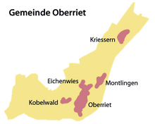
Bounded by the Rhine and the foothills of the Alpstein Mountains , Montlingen lies in the middle of the St. Gallen Rhine Valley . In addition to Kriessern , Eichenwies , Kobelwald and other hamlets, it belongs to the political municipality of Oberriet .
The older part of the village lies at the foot of the Montlinger Berg, the newer residential areas are spread around the "Bergli". On its north side is the former "Kolbenstein" quarry, which at the time of the Rhine regulation was connected with a track to the service railway of the international Rhine regulation .
The Rheintaler inland canal flows between Montlingen and Eichenwies and has the third and final barrage northeast of Montlingen with the headquarters of the Rheintaler inland canal works .
The village community is organized in the local community of Montlingen. Together with other local communities and Rhoden, it is a sub-community within the political community of Oberriet.
The local community of Montlingen owns the Montlinger Schwamm alpine area above Kobelwald , where cattle are summered in the summer months. Guests are catered for in a mountain inn.
population
As of December 31, 2009, Montlingen had 1,843 inhabitants. This corresponds to a share of 23% in the municipality of Oberriet, in which around 8,000 people live.
history
Montlingen got its name from the small Inselberg monticulus (translated: small mountain ) in the middle of the village. The history of the village began on this Montlingerberg , towering over the plain of the St. Gallen Rhine Valley . People lived here as early as the second half of the 11th century BC. Excavations from the 1920s under Hans Bessler and in the 1950s have confirmed this. The excavation site is described by the historian Werner Kuster as probably the richest prehistoric excavation site in the canton of St. Gallen .
At that time they built a large defensive wall. Due to the elevated location around 60 meters above today's village, they were also protected from the frequent floods of the Alpine Rhine . This prehistoric hilltop settlement is one of the cultural assets of national importance .
The local history museum housed in the Bergli primary school provides an overview of the 3000-year history of the village.
Infrastructure
Although Montlingen is on the A13 , it has no motorway connection. For noise protection reasons, the motorway runs for around 300 meters in a tunnel past the village center. The next two motorway connections are in Kriessern and Oberriet .
Montlingen is connected to the Austrian neighboring village of Koblach by a bridge over the Rhine. This concrete bridge, opened in 1967, replaces the old wooden bridge from 1876.
The upper school center in Montlingen belongs to the upper school community of Oberriet-Rüthi. There is also a primary school and two kindergartens.
Architectural monuments
Most of the current appearance of the Catholic parish church of Johannes Baptista dates from the last quarter of the 17th century. Only the late Gothic choir has been preserved from a previous building around 1500. During the complete restoration in 1958/59, the foundations of the first construction phase, a simple hall church from the late 8th century and a later southern extension (around the turn of the millennium) were excavated. The church should originally have been a royal own church and the ecclesiastical center of the nearby Reichshof Kriessern . In the 13th century the church lost its status as a royal own church; the patronage came to the lords of Ems , followed by various other patronage holders from the regional nobility. The church remained Catholic during the Reformation. The last renovation work was carried out at the end of the 1990s.
A way of the cross with 14 stations and at the end a wayside shrine with a statue of the 'risen Christ' leads along the way to the Montlingerberg . The St. Anna Chapel is halfway there, its age is unknown. In her choir room above the altar there is a sculpture depicting the third of Anna . There is a small Herz-Jesu chapel in Kirchweg.
Attractions
Personalities
- Hedwig Scherrer (1878–1940), Swiss artist (from 1908 lived in the studio she designed herself below the St. Anna Chapel)
- Jakob Baumgartner (1926–1996), Swiss missionary and liturgical scholar at the University of Freiburg i. Ue.
literature
- Konrad Sonderegger: The Rhine Valley around 1900 . tape 2 . Konrad Sonderegger, 1990, ISBN 978-3-85882-266-6 , p. 184 .
- Hans Rudolf Sennhauser (Ed.): Early churches in the eastern Alpine region. From late antiquity to the Ottonian period. Bavarian Academy of Sciences. Treatises - New Series, Issue 123. Publishing House of the Bavarian Academy of Sciences, Munich 2003. ISBN 3 7696 01181
Web links
- Markus Kaiser: Montlingen. In: Historical Lexicon of Switzerland .
Individual evidence
- ^ Website of the municipality of Oberriet. Retrieved on January 26, 2011 ( Memento of the original from November 29, 2012 in the Internet Archive ) Info: The archive link was automatically inserted and not yet checked. Please check the original and archive link according to the instructions and then remove this notice.
- ↑ a b Werner Kuster: Rheintaler heads . Historical-biographical portraits from five centuries. Ed .: Association for the History of the Rhine Valley. Rheintaler Druckerei und Verlag AG, Berneck 2004, ISBN 3-03300265-X , settlement, administration and politics, p. 14 .
- ↑ Sennhauser (Ed.) (2003) pp. 127–129


