St. Margrethen
| St. Margrethen | |
|---|---|
| State : |
|
| Canton : |
|
| Constituency : | Rhine Valley |
| BFS no. : | 3236 |
| Postal code : | 9430 |
| UN / LOCODE : | CH STM |
| Coordinates : | 765 661 / 257908 |
| Height : | 402 m above sea level M. |
| Height range : | 395–631 m above sea level M. |
| Area : | 6.87 km² |
| Residents: | 5890 (December 31, 2018) |
| Population density : | 857 inhabitants per km² |
| Website: | www.stmargrethen.ch |
| Location of the municipality | |
St. Margrethen , in Swiss German Sàmmagreeta , is a village and political municipality in the cultural landscape of the St. Gallen Rhine Valley in the canton of St. Gallen in eastern Switzerland . Politically, St. Margrethen is part of the Rheintal constituency .
geography
St. Margrethen is at the end of the Rhine Valley , on the banks of the Old Rhine .
The community is located between St. Gallen and Bregenz directly on the Swiss-Austrian border near the DA-CH triangle .
The Old Rhine forms the border between Austria and Switzerland. In addition to the settlement core, the municipality is divided into different areas with different geographical features. In the east, on the border with Au, is the Heldsberg with the fortress museum and the Bruggerhorn . In the south, on the road in the direction of Walzenhausen , the Schäflisberg rises , which has predominantly villa-style houses. The vineyard is the location of the historic Weinberg Castle . In between are the Heubüchel district and the Burghalde . In the west, far away from the town center, lies the hamlet of Ruderbach , which is more closely connected to Rheineck than to St. Margrethen itself. This is where the former valley station of the Rheineck – Walzenhausen cable car is located , which was built in the municipality of St. Margrethen . The area between Ruderbach and the center of the settlement is called Romenschwanden . To the north of it extends the local recreation area at Donkey's Tail , which is part of the Old Rhine and has a nature reserve. The center of the settlement of St. Margrethen is located between Hauptstrasse 13 (south) and the A13 (north) in the area between Bruggerhorn (east) and Romenschwanden (west).
Neighboring communities are Au SG and Rheineck in the canton of St. Gallen, Walzenhausen in the canton of Appenzell Ausserrhoden and Gaißau , Höchst and Lustenau in Vorarlberg .
Area balance
In 2009 St. Margrethen had a total of 686 hectares of community space. Artificially created areas amount to 231 ha. Of this, 112 ha are paved areas, 54 ha buildings, 35 ha lawns, 19 ha trees on artificially created areas, 8 ha mixed small structures, 2 ha greenhouses and 1 ha bed structures. The grass and herb vegetation takes up 183 hectares. The area of the bush vegetation is 15 hectares, 8 hectares of bushes, 4 hectares of vines and 3 hectares of bushy land. The tree vegetation extends over 213 hectares. Of this, 165 hectares are closed trees, 17 hectares are linear trees, 13 hectares of forest strips, 11 hectares of groups of trees, 4 hectares of broken trees and 3 hectares of forest areas. Water and wet areas extend over 36 ha, the area without vegetation is 8 ha.
population
| Population development | ||||||||||
|---|---|---|---|---|---|---|---|---|---|---|
| year | 1468 | 1798 | 1850 | 1900 | 1910 | 1950 | 2000 | 2005 | 2010 | 2015 |
| population | 268 | 1011 | 1129 | 1944 | 3383 | 3571 | 5285 | 5314 | 5568 | 5792 |
Due to its border location, St. Margrethen has had an increased proportion of foreigners in the past. In 2010 the proportion of foreigners in St. Margrethen was over 44%. The majority of the foreign nationals in St. Margrethen come from the Balkans , especially from Kosovo , North Macedonia , Bosnia and Herzegovina and Serbia . There is also a minority from Turkey who run the local mosque.
economy
Due to the location of St. Margrethen at the northern end of the Rhine Valley with its important Alpine passes and the proximity to the confluence of the Rhine with Lake Constance , St. Margrethen has always been an important location for transport and logistics companies . At the moment, some transport companies and logistics centers are located or have a branch in St. Margrethen. The largest bonded warehouse in the region is located opposite the train station.
The border location also explains the presence of the most important Swiss banks such as UBS , Raiffeisen Bank , St. Galler Kantonalbank and regional financial institutions such as Alpha Rheintal Bank , Rowena Bank and Volksbank AG .
With over 300 employees, Bauwerk Parkett AG is the largest industrial employer in the municipality of St. Margrethen. In the construction industry, the Gautschi Group stands out as a supraregional company from the crowd of many small construction companies in the Rhine Valley. In the northeast of St. Margrethen is the Rheinpark , which is the largest shopping center in the region on the Swiss side.
The rail vehicle manufacturer Stadler Rail is relocating its competence center for double-decker multiple units from Altenrhein to St. Margrethen. A new production plant is being built directly north of the train station, on the 65,000 square meter Altfeld area, which is currently owned by HIAG Immobilien AG. From 2020, the train manufacturer will be a major employer in the St. Margrethen community with a planned 900 employees.
traffic
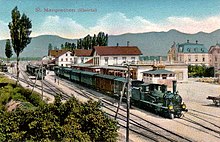
St. Margrethen is located on the north-south traffic route over the Splügen Pass, which was already used by the Romans . In 1858 the Rhine Valley line was opened via Sargans and Landquart to Chur and St. Margrethen also gained an international railway connection through the St. Margrethen – Lauterach railway to Austria, which was opened in 1872 . A Splügen railway tunnel desired by Eastern Switzerland was never tackled despite corresponding commitments from the capital Bern. With the opening of the Gotthard tunnel and the Gotthard railway in 1882, the traffic route through St. Margrethen lost its importance.
With the opening of the San Bernardino road tunnel in 1967 and the commissioning of the Gotthard road tunnel in 1980, the Rhine valley again became an important north-south transversal and St. Margrethen became an important border point for traffic. Since there is a gap in the motorway network on the two highly frequented routes Zurich - Munich and Munich - Milan from there to Bregenz (Austria) , the St. Margrethen customs office is often overloaded and there are frequent traffic jams.
After almost two months of closure due to the expansion of the line, the ÖBB line from St. Margrethen via Lustenau to Lauterach was put back into operation on March 23, 2013 . In this context, two arched suspension bridges have been built in the Bruggerhorn area, one each over the Rhine and one over the A 1 , shortly before it merges into the A 13 . The St. Margrethen – Bregenz section is part of the Munich – Zurich HGV line .
St. Margrethen is a stop for regional, Interregio-Express and Eurocity trains operated by the Swiss Federal Railways , the Austrian Federal Railways and the Deutsche Bahn .
The St. Gallen-Altenrhein airport is 10 km away and offers several scheduled flights to Vienna-Schwechat every day . The Zurich Airport ( Kloten ) is 110 km away and the Munich airport 225 km away.
St. Margrethen is also known as the eastern “gateway to Switzerland”.
history
antiquity
St. Margrethen was already an important traffic junction to the historically significant Alpine passes Splügen , Julier , Septimer and San Bernardino in Roman times . The river crossing of the Roman road Bregenz - Arbon was probably in the municipality . The Ad Rhenum mentioned on the Tabula Peutingeriana is suspected by recent research in St. Margrethen and not in Rheineck. The Roman settlement was under the administration of Brigantium / Bregenz. The prehistoric finds in St. Margrethen include a Neolithic stone ax and a late Bronze Age hilted sword .
Middle Ages and Modern Times

In the Middle Ages , St. Margrethen and Walzenhausen formed the part of the Reichshof Höchst (808 host radio) on the left bank of the Rhine . This belonged to the Rheingau , whose western border in 890 was the Eichenbach (Töbelibach) near Rheineck . The legal successors of the Rheingaugrafen - on the right of the Rhine from 1390 the Dukes of Austria , on the left of the Rhine 1490–1798 the federal places - exercised the sovereign rights. The lower court , manorial rule and collature were subordinate to the entire imperial court of the St. Gallen Abbey , which secured the area with two castles. Heldsberg Castle, built in 1271, was destroyed by the Appenzell people in 1405 . Grimmenstein Castle, built before 1254, was a fiefdom of the lords of the same name with the Lower Court , from 1315 of the Barons of Enne. In 1416 the citizens of Constance razed the castle and in 1418 the city of St. Gallen acquired the lower court. In 1483 the abbey regained full ownership of the rights, gave St. Margrethen an opening and made the court (the community) subordinate to the Obervogtei Rosenberg. In 1598, St. Margrethen and the Appenzeller ceded mutual common rights and in 1612 St. Margrethen- Höchst and St. Johann-Höchst divided them among themselves. 1831–2002 St. Margrethen was part of the Lower Rhine Valley district .
church
Ecclesiastically, St. Margrethen was a branch of St. Johann-Höchst . The church of St. Margaretha was built in the 10th century, first mentioned in 1384 and named and expanded as a parish in 1406 . From 1531 it was used equally , since 1874 it has served as a Catholic cemetery church. In 1638 Walzenhausen broke away from St. Margrethen and founded its own Reformed parish. In St. Margrethen a Reformed church was built in 1804 and a Catholic church in 1910.
economy
The village of St. Margrethen developed on the Rhine plain with the typical, loose courtyard structure of the Rhine villages. Arable and fruit growing, fishing, textile home production, sandstone quarries as well as water and land haulage offered work. The ferry between St. Margrethen and Höchst, which was occupied from the late Middle Ages , was replaced by a bridge in 1870. Until the 19th century, the vineyards in the hilly area belonged to Graubünden and St. Gallen patricians as well as the hospital and conductors' office of the city of St. Gallen. Building tools are u. a. the castle bailey (new building of 1602) and mountain climbing (1606) and the Brüggershof (1586), which in the 17th and 18th centuries Faktorei hosted the Schollnberger shipping. From the 16th century onwards, the risk of flooding increased, which was increased by the great meander of the Rhine, but St. Margrethen rejected the shortening of the river, which was planned from 1792 onwards. It was not until 1900 that the Fussacher puncture ended the threat.
In the 19th century, the state road built between 1825 and 1828 through the village of St. Margrethen, the connection to the railway network in 1858 and the rail connection to Austria in 1872 promoted development. Industrialization gave the townscape around the station urban features. In addition to machine embroidery, which dominated until 1920, a. HIAG Holzindustrie AG (founded in 1876), the lacquer factory Fey & Cie. (1902), the Rheintalische Gasgesellschaft (1903–1969 production), the import and market of timber and cattle as well as banks and freight forwarding companies. 1938–1940 the border fortress Heldsberg was built , which in 1993 was converted into a fortress museum. Thanks to the A1 / A13 national road opened in 1964 and its border location, St. Margrethen experienced an upswing, which resulted in population growth (44% foreigners in 2010) and the settlement of companies, etc. a. from the logistics and service industry. In addition, the Rheinpark shopping center opened its doors in 1974. In 2010 Bauwerk Parkett AG , founded in 1944, was the municipality's largest employer.
Culture and sights
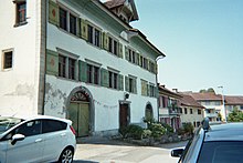
- The Grimmenstein castle ruins from the Middle Ages, located on a rocky spur that slopes steeply on three sides, are striking . In addition, there is the former fortress Heldsberg , an artillery fort from the time before the Second World War (built 1938–1940), which is now operated as a fortress museum, along with other well-preserved castles, noble mansions and manors from the time when St. Margrethen was still associated with the St. Gallen monastery .
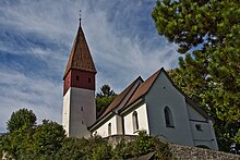
- On the north-western edge of the village stands the old church of St. Margaretha on a ridge of hills in the Appenzeller Vorderland. It is on the list of cultural assets of national importance in the canton of St. Gallen (A objects), KGS no. 8358.
- The best way to get to Schloss Weinberg is by taking the Rheineck – Walzenhausen mountain railway (Hof stop).
- The mineral spa is based on a 300-year tradition and offers a modern wellness area.
- The local recreation area Bruggerhorn has a natural outdoor pool, camping and tennis court.
- The Alter Rhein recreation area in Ruderbach has Vita Parcours, hiking trails and a nature reserve.
Personalities
Daughters and sons of the church
- Willi Rohner (1907–1977), politician (FDP)
- Albert Lampert (* 1930), architect
- Roland Zöffel (* 1938), racing cyclist
- Sepp Zellweger (* 1963), artistic gymnast and 24-time Swiss champion, participant in 2 Summer Olympic Games, 3 World Championships and 3 European Championships
See also
Web links
- Official website of the community of St. Margrethen
- Church history
- Fortress Museum Heldsberg
- St.Margrethen in the old days
Individual evidence
- ↑ Permanent and non-permanent resident population by year, canton, district, municipality, population type and gender (permanent resident population). In: bfs. admin.ch . Federal Statistical Office (FSO), August 31, 2019, accessed on December 22, 2019 .
- ↑ St. Margrethen on ortsnames.ch (online database), accessed on June 22, 2020
- ↑ Land cover statistics: Land cover (NOLC04) by district and municipality, in hectares
- ↑ Where there is construction, the population grows St. Galler Tagblatt from January 21, 2011, accessed on April 23, 2017
- ↑ Share of foreigners 44 percent: Leben in St. Margrethen srf.ch, Rundschau of May 12, 2010, accessed on April 23, 2017
- ^ Peter Müller, Markus Kaiser: Rheineck. In: Historical Lexicon of Switzerland .
-
^ A b c d e Markus Kaiser: Sankt Margrethen (SG). In: Historical Lexicon of Switzerland .
These sections are largely based on the entry in the Historical Lexicon of Switzerland (HLS), which, according to the HLS's usage information, is under the Creative Commons license - Attribution - Distribution under the same conditions 4.0 International (CC BY-SA 4.0). - ↑ Knowledge that counts: Sepp Zellweger. Munzinger Archiv GmbH, August 11, 1986, accessed December 6, 2013 .
Remarks
- ↑ The areas are given by the Federal Statistical Office in hectares (ha)


