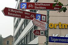
Rhine route
| Bike route 2 - Rhine route | |||||||||||||||||||||||||||||||||||||||||||||
|---|---|---|---|---|---|---|---|---|---|---|---|---|---|---|---|---|---|---|---|---|---|---|---|---|---|---|---|---|---|---|---|---|---|---|---|---|---|---|---|---|---|---|---|---|---|
| overall length | 430 km | ||||||||||||||||||||||||||||||||||||||||||||
| location |
|
||||||||||||||||||||||||||||||||||||||||||||
| Starting point |
Andermatt 46 ° 37 ′ 58.4 " N , 8 ° 35 ′ 41.4" E |
||||||||||||||||||||||||||||||||||||||||||||
| Target point |
Basel 47 ° 33 ′ 29.3 " N , 7 ° 35 ′ 15.7" E |
||||||||||||||||||||||||||||||||||||||||||||
| Flooring | Asphalt: 362 km, natural surface: 68 km | ||||||||||||||||||||||||||||||||||||||||||||
| Height difference | Elevation gain Basel - Andermatt 3200 m Elevation gain Andermatt - Basel 2000 m |
||||||||||||||||||||||||||||||||||||||||||||
| Website URL | Rhine route | ||||||||||||||||||||||||||||||||||||||||||||
|
Route
|
|||||||||||||||||||||||||||||||||||||||||||||
The Rhine Route is the national bicycle route 2 of Switzerland and forms the southernmost part of the international Rhine Cycle Route . It begins in Andermatt , leads up to the Oberalp Pass and then accompanies the Vorderrhein to Chur . It continues along the Alpine Rhine , Lake Constance and the High Rhine via St. Margrethen , Rorschach , Schaffhausen and Koblenz to Basel . The Rhine Route has a length of 430 km, 68 km of which are unsurfaced. In the direction of flow of the Rhine, 2,000 meters of altitude have to be conquered, up the Rhine 3,200 m.
Like the other national cycle routes in Switzerland, the route is marked with red signs and is maintained by Veloland Schweiz .
Connecting routes
The Baden-Württemberg Rhine Valley Trail begins in Constance and first leads around Lake Zell, Gnadensee and Untersee and, from Stein am Rhein on the German side, follows the Upper Rhine to Basel.
In Andermatt there is a connection to the Rhone route and the north-south route , in Chur to the Graubünden route , in St. Margrethen to the Alpine panorama route , in Romanshorn to the Mittelland route , in Koblenz in Aargau to the Aare route , in Basel on the Jura route and the north-south route. The route from Sargans to Rorschach forms part of both the Rhine route and the lakes route .
From Basel, the international Rhine Cycle Route continues to the mouth of the Rhine near Rotterdam .
Veloverlad
A train ride with bicycles ("Veloverlad") can save meters in altitude or avoid difficult sections. Veloland Switzerland recommends covering the following distances by train:
- Andermatt - Oberalppass or in the opposite direction Disentis - Oberalppass . An alternative recommendation is loading along the entire Andermatt – Disentis route. Meters in altitude saved: Andermatt – Oberalppass 610 m, Disentis – Oberalppass 900 m.
- Ilanz - Reichenau - Tamins . The train ride goes through the Ruinaulta . The following vertical meters are saved: Ilanz – Reichenau 300 m, in the opposite direction of travel 390 m.
Web links
- the Rhine route accessed on the Veloland Schweiz website on October 3rd
- BicycleRoutes & Tours: Rhine Route - with map, GPS download, elevation profile, sights and accommodation
Individual evidence
- ↑ a b Rhine Route , at www.schweizmobil.ch, accessed on March 7, 2018.


