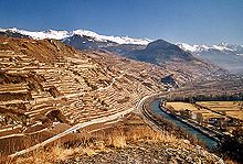
Rhone route
| Bike route 1 - Rhone route | |||||||||||||||||||||||||||||||||||||||||||||||||
|---|---|---|---|---|---|---|---|---|---|---|---|---|---|---|---|---|---|---|---|---|---|---|---|---|---|---|---|---|---|---|---|---|---|---|---|---|---|---|---|---|---|---|---|---|---|---|---|---|---|
| overall length | 350 km | ||||||||||||||||||||||||||||||||||||||||||||||||
| location |
|
||||||||||||||||||||||||||||||||||||||||||||||||
| Starting point |
Andermatt 46 ° 37 ′ 58.4 " N , 8 ° 35 ′ 41.4" E |
||||||||||||||||||||||||||||||||||||||||||||||||
| Target point |
Geneva 46 ° 12 ′ 0 ″ N , 6 ° 8 ′ 59.9 ″ E |
||||||||||||||||||||||||||||||||||||||||||||||||
| Flooring | 26 km unpaved | ||||||||||||||||||||||||||||||||||||||||||||||||
| Height difference | Altitude difference Andermatt - Geneva 2300 m Altitude difference Geneva - Andermatt 3400 m |
||||||||||||||||||||||||||||||||||||||||||||||||
| Website URL | Rhone route | ||||||||||||||||||||||||||||||||||||||||||||||||
|
Route
|
|||||||||||||||||||||||||||||||||||||||||||||||||
The Rhone Route is the National Cycle Route 1 of Switzerland . It has a length of 350 km, of which 26 km are unsurfaced.
course
It begins in Andermatt , leads over the Furka Pass and then in the canton of Valais along the Rhone over Gletsch , Brig , Sion and Martigny to Le Bouveret , where it crosses the Rhone Canal on the last bridge before Lake Geneva , the Passerelle des Grangettes . In the canton of Vaud , it continues through the Les Grangettes nature reserve and along the lake through Montreux , Lausanne and Nyon to Geneva .
The cycle path as indicated other national cycle routes in Switzerland, with red signs and of Cycling in Switzerland entertained.
Connecting routes
In Nyon there is a connection to the Jura route , in Montreux to the lakes route , in Aigle to the Alpine panorama route , in Gletsch to the Aare route , in Andermatt to the north-south route and the Rhine route .
Veloverlad
A so-called Veloverlad can save vertical meters . Using the Furka Base Tunnel , for example, saves 890 meters in altitude in the east-west direction ( Realp - Oberwald ), in the opposite direction it is 1070 meters in altitude.
Web links
- Rhone route on the Veloland Schweiz website accessed on October 3, 2017
- BicycleRoutes & Tours: Rhone route , with map, GPS download, elevation profile, sights and accommodation
Individual evidence
- ↑ a b Rhone Route , at www.schweizmobil.ch, accessed on March 7, 2018
