
Ufhusen
| Ufhusen | |
|---|---|
 |
|
| State : |
|
| Canton : |
|
| Constituency : | Willisau |
| BFS no. : | 1145 |
| Postal code : | 6153 |
| Coordinates : | 634 782 / 218510 |
| Height : | 714 m above sea level M. |
| Height range : | 612–861 m above sea level M. |
| Area : | 12.21 km² |
| Residents: | 902 (December 31, 2018) |
| Population density : | 74 inhabitants per km² |
|
Proportion of foreigners : (residents without citizenship ) |
6.7% (December 31, 2,015) |
| Website: | www.ufhusen.ch |
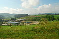
 Ufhusen from the village entrance |
|
| Location of the municipality | |
  |
|
Ufhusen is a municipality in the Willisau constituency in the canton of Lucerne in Switzerland .
geography
The municipality is located in the hill country 7 km west of Willisau on the canton border of Bern / Lucerne. The southern boundary of the municipality is formed by the Warmisbach , which first flows northeast from Hegenwald to Bärenhüsli (municipality of Luthern ) and then to the north, where it joins the (Gondiswiler-) Rotbach from the right in Hüswil (district of Zell LU ) . The north-western border and at the same time the canton border runs along the Ibach , which joins the (Gondiswiler-) Rotbach from the right at the Gondiswil stop . The Eschwald and the Gummerenwald lie south of the Ibach . The village is located in a high valley south of Hüswil. The hamlet of Engelprächtigen ( 658 m above sea level ) is 900 m northwest of the village south of the Rotbach. The municipality also includes the Ruefswil district ( 653 m above sea level ; 1.5 km southeast) on the Luthern in the valley of the same name. Many other small hamlets and farms can be found south of the village. The highest point of the community is on the Hilferdingerberg at 860 m above sea level. M. , the deepest on the Ibach at 616 m above sea level. M.
One fifth (20.7%) of the municipal area of 1225 ha is covered by forest. As a result of the many clearings, 73.6% is used for agriculture. Another 5.6% is settlement area.
Ufhusen borders on Fischbach , Luthern , Willisau and Zell in the canton of Lucerne, as well as on Eriswil , Gondiswil and Huttwil in the canton of Bern .
population
| Population development | |
|---|---|
| year | Residents |
| 1798 | 950 |
| 1850 | 1'003 |
| 1880 | 947 |
| 1888 | 851 |
| 1900 | 837 |
| 1941 | 975 |
| 1980 | 738 |
| 1990 | 774 |
| 2000 | 789 |
| 2004 | 841 |
The population grew only slightly from 1798 to 1850 (1798–1850: +5.6%). After that, the community was sucked into rural exodus, the migration from the rural communities to the industrial centers. The number of residents fell until 1900 (1850–1900: −16.6%); particularly strong from 1880 to 1888 (1880–1888: −10.1%). Apart from two short phases of stagnation, by 1941 it grew back to almost the level of 1850 (1900–1941: + 16.5%). After that, a second major wave of emigration began, which lasted until 1980 (1941–1980: –24.3%), when the population bottomed out. Since then, the population has been growing again (1980–2004: +14.0%).
languages
The population uses a highly Alemannic dialect as their everyday language. In the last census in 2000, 98.61% said German and 0.51% each of French and Albanian were the main languages.
Religions - denominations
In the past, all residents were members of the Roman Catholic Church. This has changed as a result of leaving the church and immigration from other regions in Switzerland and abroad. Today (as of 2000) the religious landscape looks like this. There are 72.62% Roman Catholic and 21.42% Evangelical Reformed Christians. In addition, there are 1.77% non-denominational and 0.51% Muslim.
Origin - nationality
At the end of 2014, 836 of the 876 inhabitants were Swiss and 40 (= 4.6%) were foreigners. The population consisted of 95.4% Swiss citizens. At the end of 2014, the foreign residents came from Germany (40.0%), Italy (2.5%) and Portugal (2.5%). 52.5% came from the rest of Europe and 2.5 % came from outside Europe.
history
The place was first mentioned in 1160 in the Acta Murensia , an inventory of the Muri monastery in the canton of Aargau. There a Ymzo nobilis de Ufhusen is listed as a patron. The community fell to the Habsburgs in the 13th century and became part of the county of Willisau. The city of Lucerne bought it in 1407 and made it the Landvogtei Willisau. The lower jurisdiction exercised - first on behalf of the Habsburgs, then from Lucerne - the lords of Büttikon . In 1516, Lucerne also took over lower jurisdiction . Until 1798 nothing changed in the balance of power. In that year Ufhusen became part of the Willisau district and in 1803 came to the then newly created office of Willisau .
politics
Municipal council
The Ufhusen municipal council consists of five members and is set up as follows:
- Claudia Bernet-Bättig: Mayor
- Renate Gerber-Schär
- Josef Müller-Agner
- Chantal Filliger-Renggli
- Marcel Schmid
Cantonal elections
In the 2015 Cantonal Council elections for the Canton of Lucerne, the share of the vote in Ufhusen was: CVP 64.0%, SVP 23.4%, FDP 10.1%, GPS 1.0%, SP 0.9%, glp 0.6%.
National Council elections
In the Swiss parliamentary elections 2015, the share of the vote in Ufhusen was: CVP 42.1%, SVP 39.5%, FDP 9.4%, SP 2.4%, glp 3.0%, BDP 1.7%, Greens 0, 8th %.
traffic
Ufhusen is connected to the public transport network by the Hüswil-Ufhusen post bus line. In Hüswil there is a stop on the Lucerne-Langenthal railway line. Ufhusen is not on any main road and the next motorway connections in Sursee and Dagmersellen on the A2 are both 19 km away.
photos

Ufhusen seen from the hill between Lochmüli and Ruefswil

Warmisbach near Lochmüli, Ufhusen
Quarry pond and gravel pit near Ruefswil


Web links
- Official website of the municipality of Ufhusen
- Community profile of the cantonal statistical office (PDF; 104 kB)
- Waltraud Hörsch: Ufhusen. In: Historical Lexicon of Switzerland .
Individual evidence
- ↑ Permanent and non-permanent resident population by year, canton, district, municipality, population type and gender (permanent resident population). In: bfs. admin.ch . Federal Statistical Office (FSO), August 31, 2019, accessed on December 22, 2019 .
- ↑ Permanent resident population according to nationality category, gender and municipality ( memento of the original from January 1, 2015 in the Internet Archive ) Info: The archive link was inserted automatically and has not yet been checked. Please check the original and archive link according to the instructions and then remove this notice. (Permanent resident population)
- ↑ Balance of the permanent resident population according to demographic components, institutional structure, nationality and gender (Federal Statistical Office, STAT-TAB)
- ↑ LUSTAT: Community profile Ufhusen ( Memento of the original from May 8, 2016 in the Internet Archive ) Info: The archive link has been inserted automatically and has not yet been checked. Please check the original and archive link according to the instructions and then remove this notice.
- ↑ LUSTAT: Community profile Ufhusen ( Memento of the original from May 8, 2016 in the Internet Archive ) Info: The archive link has been inserted automatically and has not yet been checked. Please check the original and archive link according to the instructions and then remove this notice.
- ↑ National Council elections 2015: strength of the parties and voter turnout by municipality. In: Results of the National Council elections 2015. Federal Statistical Office, 2016, accessed on June 3, 2016 .
Alberswil | Altbüron | Altishofen | Dagmersellen | Egolzwil | Ettiswil | Fischbach | Gettnau | Grossdietwil | Hergiswil near Willisau | Luther | Menznau | Nebikon | Pfaffnau | Reiden | Roggliswil | Schötz | Ufhusen | Wauwil | Wikon | Willisau | Cell
Former parishes: Buchs | Boar corners | Kottwil | Langnau near Reiden | Ohmstal | Richenthal | Uffikon | Willisau Land | Willisau city
Canton of Lucerne | Constituencies of the Canton of Lucerne | Municipalities of the Canton of Lucerne