
Richenthal
| Richenthal | ||
|---|---|---|
 |
||
| State : |
|
|
| Canton : |
|
|
| Constituency : | Willisau | |
| Residential municipality : | Reiden | |
| Postal code : | 6263 | |
| former BFS no. : | 1141 | |
| Coordinates : | 638 272 / 229741 | |
| Height : | 506 m above sea level M. | |
| Area : | 7.22 km² | |
| Residents: | 708 (December 31, 2004) | |
| Population density : | 98 inhabitants per km² | |
| Website: | www.richenthal.ch | |
| map | ||
|
||


Up until December 31, 2005, Richenthal was a political municipality in the Willisau district of the canton of Lucerne in Switzerland .
On January 1, 2006, Richenthal merged with the communities of Langnau bei Reiden and Reiden to form the new community of Reiden .
geography
Ridu , as the former community is called by the locals, is a farming village in a branch on the left of the Wiggertal in the north-west of the canton of Lucerne. The entire former municipality area is hilly. To the east of the village rises the partially wooded Schallberg (in the municipality up to a maximum of 614 m above sea level).
The hamlet of Kreuzstrasse (516 m above sea level) is 500 m south of the village. Another 1.3 km south is the Hueb district, through which the Huebbach flows, (524-537 m. Above sea level) with a spa center. At the Kurhaus the Ränzligenbach flows into the Huebbach. Inner Fronhofen lies further to the west (653 m above sea level; 2.7 km southwest of the village) south of the Klempenwald . The western border at Klempen leads to the highest point of the municipality at 716 m. ü. The hamlets of Reckenberg (west of Kurhaus Hueb) and Ränzligen 1 km west of the village (611 m. Above sea level) and the hamlet of Gugger (1 km northwest of the village) with the Guggerhöhe (704 m. Above sea level) are the most important of the remaining settlements. Of the total community area of 722 hectares, 67.0% is used for agricultural purposes; a quarter (25.2%) is covered by forest and 7.3% is settlement area.
Richenthal bordered Altishofen , Ebersecken , Grossdietwil , Langnau bei Reiden and Pfaffnau and Dagmersellen .
population
Population development
The community grew continuously until 1888. By 1900, there was a mass migration to the industrial centers (1888–1900: −15.1%). The next two decades brought significant population growth (1900–1920: + 20.0%). In the 1920s, the population began to decline again, but this was followed by population growth until 1950 - so that the population of 1950 corresponds exactly to that of 1920. The next two decades saw a slight population decline. The number of residents has been growing steadily since 1970 and has now reached the highest level of over 700 residents (1970–2004: +34.9%).
| Population development | |
|---|---|
| year | Residents |
| 1850 | 513 |
| 1888 | 570 |
| 1900 | 484 |
| 1920 | 581 |
| 1930 | 526 |
| 1950 | 581 |
| 1970 | 525 |
| 1990 | 613 |
| 2000 | 662 |
| 2004 | 708 |
languages
The population uses a highly Alemannic dialect as their everyday language. At the last census in 2000, 91.24% said German, 5.74% Albanian and 0.45% Portuguese were their main languages.
Religions - denominations
In the past, all residents were members of the Roman Catholic Church. This has changed as a result of leaving the church and immigration from other regions in Switzerland and abroad. Today (as of 2000) the religious composition of the population is as follows. There are 68.28% Roman Catholic and 12.99% Evangelical Reformed Christians. In addition, there are 8.76% Muslims and 4.38% non-denominational. 4.98% of the population refused to fill out the denomination information. With a few exceptions, the Muslims are of Albanian origin.
Origin - nationality
Of the 708 inhabitants at the end of 2004, 614 were Swiss and 94 (= 13.3%) were foreigners. At the last census, 84.29% (including dual citizens 86.25%) were Swiss citizens. The largest group of immigrants comes from Kosovo. In 2000, this group made up 74% (84.6% without dual citizenship) of all non-Swiss citizens. There are also individual foreigners from seven other countries.
traffic
Richenthal is connected to the public transport network by the Zofingen – Reiden – Richenthal bus line operated by Limmat Bus . In Reiden there is a train station on the Luzern-Olten line. The place is on the road Reiden-Richenthal-Ebersecken (-Fischbach LU). The next motorway connections to the A2 are not far away. Dagmersellen is 4 km away and Reiden is 5 km away, a major factor in the continued population growth.
history
Richentale is first mentioned in 1036 when Count Ulrich I von Lenzburg donated the local church to the Beromünster Canons. So the church must actually have existed before. The sovereignty passes from the Lenzburgers to the Habsburgs . In fact, they lost this to the expanding city of Lucerne after the battle of Sempach in 1386 . Nevertheless, Lucerne did not officially take over the reign until 1415. Together with Langnau bei Reiden, Richenthal formed the Richenthal office until 1478, in which the Beromünster canon monastery had lower jurisdiction. From then until 1798 the place belongs to the Landvogtei Willisau. From 1798 to 1803 Richenthal belonged to the Altishofen district, since then to the newly established Willisau Office .
In 1846 Langnau separated from Reiden and became an independent municipality. On January 1, 2006, both communities were merged with Reiden .
Attractions
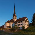
Parish church and rectory

Primary school building

Gasthaus Lamm

former Kurhaus

Gut-Hirt-Chapel (Kurhaus)


Web links
- Max Huber: Richenthal. In: Historical Lexicon of Switzerland .
Alberswil | Altbüron | Altishofen | Dagmersellen | Egolzwil | Ettiswil | Fischbach | Gettnau | Grossdietwil | Hergiswil near Willisau | Luther | Menznau | Nebikon | Pfaffnau | Reiden | Roggliswil | Schötz | Ufhusen | Wauwil | Wikon | Willisau | Cell
Former parishes: Buchs | Boar corners | Kottwil | Langnau near Reiden | Ohmstal | Richenthal | Uffikon | Willisau Land | Willisau city
Canton of Lucerne | Constituencies of the Canton of Lucerne | Municipalities of the Canton of Lucerne