Beromünster
| Beromünster | |
|---|---|
| State : |
|
| Canton : |
|
| Constituency : | Sursee |
| BFS no. : | 1081 |
| Postal code : | 6025 Neudorf 6215 Beromünster 6215 Schwarzenbach 6222 Gunzwil |
| Coordinates : | 657 691 / 227952 |
| Height : | 642 m above sea level M. |
| Height range : | 449–854 m above sea level M. |
| Area : | 42.13 km² |
| Residents: | 6580 (December 31, 2018) |
| Population density : | 156 inhabitants per km² |
|
Proportion of foreigners : (residents without citizenship ) |
12.7% (December 31, 2,015) |
| Website: | www.beromuenster.ch |
|
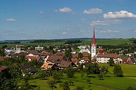
View of Beromünster |
|
| Location of the municipality | |
Beromünster ( ; until 1934 Münster, Swiss German Möischter ) is a municipality in the Swiss canton of Lucerne . It belongs to the Sursee constituency .
geography
Beromünster is located in the upper area of the Wynental and is traversed by the Wyna . With the exception of small areas on the banks of the Wyna and part of the Wiholz forest in the south of the village, the entire municipality has been cleared. Of the total municipal area, 65.2% is agricultural land, 25.4% is settlement area and only 9.1% is forest and wood.
The formerly independent community of Schwarzenbach ( 662 m above sea level ; 3.2 km north-northeast of Beromünster) formed an exclave since it was merged with Beromünster on September 1, 2004 and until the merger with Gunzwil on January 1, 2009 . The village lies on the northern tip of the Erlosen between Wynen- and Lake Valley . The eastern slope of the Erlosen towards Seetal is still partly heavily forested. South-southeast of the village is the Hohwacht hill , which is 691 m above sea level. M. forms the highest point of the municipality. In addition to the actual village, there are the hamlets Lüsch (in the north), Grüt (in the northeast) and the group of houses Rüti (in the south-southeast). The Schwarzenbach rises to the west of Beromünster and , after a short run, flows into the Wyna.
Beromünster borders the communities of Eich , Ermensee , Geuensee , Hildisrieden , Hitzkirch , Rickenbach LU , Römerswil ( Herlisberg district ), Schenkon and Sempach in the canton of Lucerne, as well as the communities of Beinwil am See and Menziken in the canton of Aargau .
population
At the end of 2015 the community had 6,444 inhabitants. Of these, 5,623 were Swiss citizens and 821 (= 12.7%) were foreigners. The following table shows the population development of the municipality in today's borders (old municipalities Beromünster, Schwarzenbach and Gunzwil):
| year | 2000 | 2005 | 2006 | 2007 | 2008 | 2009 | 2010 | 2011 | 2012 | 2013 | 2014 | 2015 |
| Residents | 4,414 | 4,419 | 4,407 | 4,412 | 4,437 | 4,497 | 4,665 | 5,963 | 6,033 | 6,112 | 6'234 | 6'444 |
Population development
The population of Beromünster grew from 1798 to 1860 (1798-1860: + 27.6%). Thereafter it remained stable with the exception of the year 1900–1930. Thereafter, it grew sharply until 2000 (with the exception of the 1950s) (1930–2000: +98.2%).
The population of Schwarzenbach rose slightly from 1850 to 1870 and then fell to its historical low by 1888. Otherwise, it remained between 171 and 188 inhabitants until 1970. With the exception of the 1980s, there was strong growth until 2000 (1970–2000: + 23.9%). Since then the population has stagnated.
| Population development in the district of Schwarzenbach |
|
|---|---|
| year | Residents |
| 1850 | 189 |
| 1870 | 196 |
| 1888 | 169 |
| 1900 | 183 |
| 1920 | 179 |
| 1941 | 178 |
| 1960 | 182 |
| 1970 | 188 |
| 1980 | 204 |
| 1990 | 208 |
| 2000 | 233 |
| 2004 | 231 |
| Population development in the Beromünster district |
|
|---|---|
| year | Residents |
| 1798 | 939 |
| 1837 | 1,071 |
| 1860 | 1,198 |
| 1900 | 973 |
| 1930 | 1'190 |
| 1950 | 1,434 |
| 1960 | 1,443 |
| 1970 | 1,552 |
| 1980 | 1,836 |
| 1990 | 2,094 |
| 2000 | 2,358 |
| 2004 | 2,301 |
language
The population speaks a highly Alemannic dialect as everyday language. The last census in 2000 showed the following:
- Beromünster community
90.1% gave German, 4.6% Albanian and 2.1% Serbo-Croatian as their main language.
- Schwarzenbach district
96.57% gave German, 1.72% Italian and 0.86% French as their main language.
Religions - denominations
In the past, all residents were members of the Roman Catholic Church. Today the religious landscape looks like this (as of 2000):
- Beromünster district
80.41% Roman Catholic, 7.08% Evangelical Reformed and 1.91% Orthodox Christians. In addition, 5.47% Muslims and 2.80% non-denominational.
- Schwarzenbach district
77.68% Roman Catholic, 14.59% Evangelical Reformed and 1.72% Free Church Christians. In addition, 3.86% non-denominational and 1.29% Muslim.
- Beromünster community
80.16% Roman Catholic, 7.76% Evangelical Reformed and 1.74% Orthodox Christians. In addition, 5.09% Muslims and 2.89% non-denominational.
Origin - nationality
At the end of 2014, 5,491 of the 6,234 inhabitants were Swiss and 743 (= 11.9%) were foreigners. The population consisted of 88.1% Swiss citizens. At the end of 2014, the foreign residents came from Serbia including Kosovo (32.6%), Germany (23.6%), Italy (9.8%), Portugal (6.5%), Turkey (1.9%) and Spain (0.5%). 18.8% came from the rest of Europe and 6.3 % came from outside Europe.
history

Place name
In the Old Confederation, the name Münster im Aargau was used to differentiate between them until the end of the 18th century. Until 1934 the community was officially called Münster . After the construction of the state transmitter Beromünster (1931), the village was renamed Beromünster to differentiate it on the radio transmitter scale from the MW station Münster in Westphalia. If the municipality had not agreed to the name change, the state transmitter located in the municipality of Gunzwil would have been named after the nearby town of Sursee . It was named after the Beromünster canon monastery located in the village , which, according to legend, was built by Count Bero von Lenzburg in memory of his son Adalbert, who died in a duel with a bear.
Event history
The political communities Beromünster, Gunzwil and Schwarzenbach were formed in the area of the Canons' Monastery. From the mergers of the municipalities in 2004 and 2009, today's municipality of Beromünster was created with the districts of Beromünster, Gunzwil and Schwarzenbach.
On the night of March 12, 1764, the so-called Fläckenfire destroyed 86 residential and commercial buildings and six barns. Around 360 people were left homeless. Just a few days after the fire, the destroyed town center was measured and new plans for the reconstruction were prepared. It was rebuilt within four years and has remained largely unchanged to this day.
Mergers
The old municipality of Beromünster merged on September 1, 2004 with the municipality of Schwarzenbach. On June 17, 2007, the voters of the communities Beromünster and Gunzwil approved the merger of the two communities. This merger was completed on January 1, 2009. In June 2011 the “Michelsamt together” project, which envisaged a merger of the municipalities of Beromünster, Neudorf, Pfeffikon and Rickenbach, was stopped after negotiations with the canton, as Beromünster judged the cantonal contribution of 18 million francs offered to be too low. Then two merger projects between Beromünster and Neudorf and Rickenbach and Pfeffikon were launched. The merger of Beromünster with the neighboring municipality to the south of Neudorf took place on January 1, 2013. The name “Beromünster” was retained in all these mergers.
On January 1, 2015, the area of 29,069 m² in the hamlet of Tann changed from the municipality of Beromünster to the municipality of Schenkon .
politics
Municipal council
The Beromünster municipal council consists of five members and is set up as follows:
- Hans-Peter Arnold (FDP): Mayor
- Carmen Beeli-Zimmermann (CVP): Social
- Hanspeter Lang (CVP): Construction and finance
- Lukas Steiger (FDP): Security and Environment
- Manuela Jost-Schmidiger (CVP): Education
Cantonal elections
In the 2015 cantonal elections for the Canton of Lucerne, the share of the vote in Beromünster was: CVP 40.5%, FDP 24.4%, SVP 21.7%, SP 5.0%, GPS 3.7%, glp 3.5%.
National Council elections
In the 2015 Swiss parliamentary elections, the share of the vote in Beromünster was: CVP 31.4%, FDP 26.8%, SVP 25.3%, SP 6.2%, glp 4.3%, GPS 3.9%, BDP 1, 2%.
In the Swiss parliamentary elections 2019, the voter shares in Beromünster were: CVP 40%, SVP 25%, FDP 15%, SP 6%, Greens 7%, GLP 5%
traffic
In 1905/1906 a railway was built from Reinach AG to Beromünster . In Beinwil there was a connection to the Seetalbahn; however, this branch line was abolished in 1992. Today Beromünster is served by three bus lines: Beromünster-Beinwil am See (with connection to the Lucerne – Lenzburg railway line ), Lucerne-Beromünster (–Rickenbach or –Menziken) and Sursee – Schenkon – Beromünster (with a connection in Sursee to the Lucerne railway line –Olten).
The place is on the main roads Sursee-Reinach AG and Lucerne-Aarau . The closest motorway connections are Sursee 10 km away and Sempach 12 km away - both on the A2 .
Between the Sempacher and Baldeggersee lakes, closer to Neudorf than to Beromünster, there is the small Lucerne-Beromünster airfield ( ICAO code : LSZO) with a grass runway that is used by motorized and glider pilots as well as parachutists and helicopter pilots. The airfield is located at an altitude of 2146 ft (654 m above sea level ). The airport coordinates are 47 ° 11 '22 "N / 8 ° 12' 16" E
education
Beromünster is the seat of the Beromünster Cantonal School , which is the successor to the old collegiate school. This is attended by almost 400 schoolchildren and around fifty teachers are taught. The community also has a primary school with its own secondary school.
Beromünster Abbey

The collegiate monastery, newly founded in 1036 by the Counts of Lenzburg and still in existence today, had an extraordinary number of secular and ecclesiastical rights until 1798 and was considered to be one of the richest ecclesiastical lords on federal territory. A few key words about its cultural wealth: the school, first mentioned in 1226, the first dated Swiss book printing press in 1470 and a rich musical collection with works from the Middle Ages to the Classical written especially for the pen.
In 1415, the city of Lucerne took over the imperial fiefdom of the cast or umbrella bailiwick and in 1420 acquired the area belonging to it, the so-called Michelamt . The local rule was only partially integrated into the state rule. In this territorially almost closed area, the monastery also had the lower court, i.e. twing and ban, in addition to its dominant position as landlord . At the same time it was the sole tithe over the incorporated parishes. As the actual "rule within the rule", the provost in Beromünster exercised not only police and military functions but also the high level of jurisdiction; in the Michelsamt Landvogtei he shared this task and income with the city governor.
The Michelsamt was neither the largest nor the most profitable Lucerne Landvogtei. Nevertheless, the monastery was particularly important for the Lucerne authorities: On the one hand, because of its exposed location on the border with the Bernese, after the Reformation, Aargau , which was of different faiths, it was an important outpost of the Catholic state. In addition, the monastery played an important role in politics.
In this Michelsamt the provost embodied the rule, because Lucerne was far away and the city bailiffs were rarely present. The provost was responsible for the military organization. He appointed the pastors and - in the Reformed areas - the preachers in the name of the monastery. Through its manorial rule , the monastery was the largest land and forest owner in Michelsamt, almost everyone in the village or in the villages received house and farm as fiefs from the provost's hands.
Country transmitter Beromünster
The state transmitter Beromünster , which used to be in the neighboring municipality of Gunzwil , was opened on June 11, 1931 and expanded with the Blosenberg tower built in 1937 . In this way, Beromünster became widely known, especially during the Second World War , when intellectual national defense was also based largely on the new propaganda medium of radio. Radio Beromünster, from which the Swiss radio DRS emerged , on medium wave 529 kHz (from 1978 531 kHz), could be received in large parts of Europe. The system broadcast the DRS Musikwelle program until December 28, 2008 at midnight (CET) and was shut down and shut down on December 31, 2008 at midnight (CET) after 77 years.
Attractions
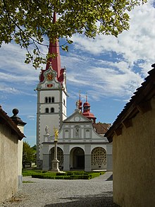
The collegiate church of St. Michael emerged from an early Romanesque building, the proportions of which are still recognizable despite several renovations in the late Middle Ages and the Baroque era. Church and monastery buildings form a baroque ensemble of buildings.
On the day of the ascent there is the tradition of a ride around.
Personalities
- Helias Helye (around 1400–1475), canon in Beromünster, printed the first dated book in Switzerland
- Heinrich von Gundelfingen (1440 / 50–1490), canon in Beromünster, is considered a pioneer of humanism
- Josef Felix Ineichen (1745–1818), pastor and pioneer of dialect literature
- Franz Joseph Stalder (1757–1833), pastor, educator and dialectologist
- Marian Herzog (1758–1828), Benedictine priest, university professor and opposition to the French invasion
- Jost Bernhard Häfliger (1759–1837), pastor, promoter of rural education and pioneer of dialect literature
- Franz Bernhard Göldlin von Tiefenau (1762–1819), provost of the Abbey in Beromünster, saved the Abbey in Helveticia from being dissolved
- Ignaz Paul Vitalis Troxler (1780–1866), doctor, politician and philosopher
- Januarius I, Dangel, von Beromünster, abbot of the Rheinau monastery 1758–1775
- Joseph Eutych Kopp (1793–1866), historian and politician
- Renward Brandstetter (1860–1942), linguist and theater historian
- Lorenz Rogger (1878–1954), provost of the Beromünster monastery
- Josef Vital Kopp (1906–1966), writer and priest
- Ludwig Hasler (* 1944), philosopher and publicist
- Pirmin Meier (* 1947), canton school teacher in Beromünster and writer
- Alois Estermann (1954–1998), 31st Commander of the Pontifical Swiss Guard
literature
- Anton Gössi: Beromünster (municipality). In: Historical Lexicon of Switzerland .
- Waltraud Hörsch: Schwarzenbach (community). In: Historical Lexicon of Switzerland .
- Beromünster - Stiftstheater & Schol , Nethalie Wey, Miriam Wirthner, Monument Preservation and Archeology of the Canton of Lucerne, 2013
- Anton Dormann, Josef Wallimann: The history of the parish St. Stephan Beromünster. 1959.
- Fritz Glauser, JJ Siegrist: The Lucerne parishes and bailiffs. Lucerne 1977.
- Adolf Reinle : The art monuments of the canton of Lucerne. Volume IV: The Sursee Office. (= Art Monuments of Switzerland. Volume 35). Edited by the Society for Swiss Art History GSK. Bern 1956, ISBN 978-3-906131-23-8 .
- Philipp Anton von Segesser : Legal history of the city and republic of Lucerne. 4 vol., Lucerne 1850–58.
- Anton Suter: Beromünster then and now. Beromünster 1986.
- Beromünster fifty years ago , Xaver Herzog, Beromünster 1944.
pen
- Anton Gössi: Beromünster (pen). In: Historical Lexicon of Switzerland .
- Helene Büchler-Mattmann: The Beromünster Abbey in the late Middle Ages. 1976.
- Peter Eggenberger : The Beromünster Abbey. 1986.
- Gregor Egloff: Herr in Münster: The rule of the collegiate monastery St. Michael in Beromünster in the Lucerne Landvogtei Michelsamt at the end of the Middle Ages and in the early modern period (1420-1700). Basel 2003, ISBN 3-7965-1918-0 .
- André Meyer: Schweizerische Kunstführer GSK, Volume 660/670: Stift und Stiftskirche St. Michael in Beromünster. Bern 2000, ISBN 3-85782-669-X .
Web links
- Website of the Beromünster community
- Community profile of the cantonal statistical office (PDF, 113 kB)
- Beromünster photographs and history in the Beromünster community portal of the Fotodok Foundation
- 360-degree panorama of the Beromünster canon monastery
- Sounds from the edge of the history Beromünster Radioweg
Individual evidence
- ↑ Permanent and non-permanent resident population by year, canton, district, municipality, population type and gender (permanent resident population). In: bfs. admin.ch . Federal Statistical Office (FSO), August 31, 2019, accessed on December 22, 2019 .
- ↑ Permanent resident population by nationality category, gender and municipality ( memento from January 1, 2015 in the Internet Archive ) (permanent resident population)
- ↑ ortsnames.ch , accessed January 3, 2020.
- ↑ Balance of the permanent resident population according to demographic components, institutional structure, nationality and gender (Federal Statistical Office, STAT-TAB)
- ↑ LUSTAT: Beromünster community profile ( Memento from May 7, 2016 in the Internet Archive )
- ↑ Documentation Fleckenbrand 1764
- ^ Parish mergers and planned parish mergers in the canton of Lucerne
- ↑ Change of the municipal boundary "Tann area" between the municipality of Beromünster and municipality of Schenkon (pdf)
- ↑ LUSTAT: Beromünster community profile ( Memento from May 7, 2016 in the Internet Archive )
- ↑ National Council elections 2015: strength of the parties and voter turnout by municipality. In: Results of the National Council elections 2015. Federal Statistical Office, 2016, accessed on June 1, 2016 .
- ^ Aegidius Tschudi: Cronicon Helveticum
- ↑ Facts on the myth of Radio Beromünster - a look back at the era of 77 years of radio history , NZZ , December 27, 2008
- ↑ Driveway ride ( Memento from May 29, 2016 in the Internet Archive )


