
Römerswil
| Römerswil | |
|---|---|
 |
|
| State : |
|
| Canton : |
|
| Constituency : | Hochdorf |
| BFS no. : | 1039 |
| Postal code : | 6027 Römerswil 6028 Herlisberg |
| Coordinates : | 661 199 / 224 624 |
| Height : | 723 m above sea level M. |
| Height range : | 463–807 m above sea level M. |
| Area : | 16.60 km² |
| Residents: | 1789 (December 31, 2018) |
| Population density : | 108 inhabitants per km² |
|
Proportion of foreigners : (residents without citizenship ) |
6.4% (December 31, 2,015) |
| Website: | www.roemerswil.ch |
_220.JPG) Village center of Römerswil |
|
| Location of the municipality | |
  |
|
Römerswil is a municipality in the Hochdorf constituency in the canton of Lucerne in Switzerland .
geography
The village of Römerswil is located southwest of the Baldeggersee 3 km west of Hochdorf on the eastern slope of the Erlosen . The village of Herlisberg ( 737 m above sea level ), an independent municipality until January 1, 2005 and now a district, is 3.3 km northwest of it. The municipal area includes numerous hamlets, groups of houses and individual farms. The northernmost settlements in the municipality are Waldhaus ( 794 m above sea level ; 4 km northwest) and the hamlet of Laufenberg ( 593 m above sea level ; 4 km north of the village of Römerswil). In the hamlet of Ober-Reinach ( 734 m above sea level ; 2.2 km north of the village) are the ruins of Ober-Reinach Castle. The hamlet of Ludigen ( 753 m above sea level ) lies exactly between the village and Ober-Reinach . The community extends with the district Nunwil ( 476 m above sea level ; 2 km northeast of the village) down to the south bank of the Baldeggersee. Immediately west of Hochdorf, already in the Seetal plane, is the district of Huwil ( 471 m above sea level ; 2.3 km east of the village), through which the Sagenbach flows. 2.3 km to the south-east is the southernmost point of the municipality, the hamlet of Rehag. In the south of the municipality is the Williswil district ( 686 m above sea level ; 1.1 km south of the village).
The municipality covers an area of 1739 hectares, of which only 1665 hectares are land. The rest is the community part on Baldeggersee. 77.1% of this land area is used for agriculture; 16.2% of the community area is covered with forest and wood and only 6.5% settlement area.
Neighboring communities of the community according to the new territorial status from January 1, 2009 are Beromünster , Ermensee , Hildisrieden , Hitzkirch , Hochdorf and Rain .
population
| Population development | |
|---|---|
| year | Total population |
| 1850 | 1,451 |
| 1888 | 1,015 |
| 1900 | 1,043 |
| 1910 | 1'230 |
| 1941 | 1'303 |
| 1950 | 1,340 |
| 1970 | 1'236 |
| 1990 | 1,333 |
| 2000 | 1,468 |
| 2010 | 1,627 |
| Population development | |
|---|---|
| year | Inhabitants of Römerswil old municipal area |
| 1850 | 1,189 |
| 1888 | 840 |
| 1900 | 851 |
| 1910 | 1,040 |
| 1920 | 1,109 |
| 1930 | 1,063 |
| 1970 | 1,071 |
| 1990 | 1,112 |
| 2000 | 1,229 |
- Römerswil (old municipality)
The population decreased massively by 29.4% from 1850 to 1888 due to emigration and then increased massively between 1900 and 1910. A constant ups and downs in the range from 1,040 to 1,150 followed until 1990. Since then, the population has increased again at a moderate pace and, before the merger with Herlisberg, numbered 1,270 people.
- Herlisberg
The number of inhabitants grew in small but steady steps between 1798 and 1860. After that, it fell massively through emigration until 1888. From this time until 1960 it was constantly in the range between 175 and 192 people (except in the year 1941, where it was slightly higher). The low of 1970 was followed by a surge in growth up to the year 2000. Since then it has fallen a little. Before the merger with Römerswil, Herlisberg had 225 inhabitants. More at Herlisberg
languages
The population speaks a highly Alemannic dialect in everyday life . At the last census in 2000, the language situation looked like this:
- Römerswil (old municipality)
98.70% German and 0.16% French and Romansh were the main languages.
- Herlisberg
96.23% gave German, 2.93% Serbo-Croatian and 0.42% French as their main language.
Religions - denominations

In both merged parishes, the population is traditionally Roman Catholic. As a result of leaving the church and immigration, the religious landscape looks as follows today (as of 2000):
- Römerswil (old municipality)
Of the population, 83.97% were Roman Catholic and 6.59% Evangelical Reformed Christians. There were also 5.21% non-religious and 0.49% Muslim.
- Herlisberg
78.66% of the population were Roman Catholic and 7.53% Protestant Reformed Christians. In addition, there were 6.28% non-denominational and 2.51% Muslim.
- Römerswil (new municipal area)
Of the population, 83.11% were Roman Catholic and 6.74% Evangelical Reformed Christians. There were also 5.38% non-religious and 0.89% Muslim.
Origin - nationality
At the end of 2014, of the 1,669 inhabitants, 1,580 were Swiss and 89 (= 5.3%) were foreigners. The population consisted of 94.7% Swiss citizens. At the end of 2014, the foreign residents came from Germany (53.9%), Italy (10.1%), Serbia including Kosovo (9.0%), Portugal (3.4%) and Spain (1.1%). 19.1% came from the rest of Europe and 3.4 % came from outside Europe.
history


The Herlisberg district appears for the first time as Erlinsberg in 1150 in a confirmation of ownership from the Allerheiligen monastery in Schaffhausen . The community was first subordinate to the Counts of Lenzburg , then from 1173 to the Counts of Kyburg and as their successors from 1263 to the Habsburgs . All these gentlemen left the administration to the Knights of Reinach, who had their seat in Oberrinach Castle. In 1386 at the Battle of Sempach , however, they fought on the side of the losers, the castle was destroyed and Lords of Reinach left for Alsace . Herlisberg belonged to the free offices until 1803 as part of the Richensee-Hitzkirch office and then came to the newly created Hochdorf office . Until the end of 2004 it was an independent municipality. Since January 1, 2005 it has been a district of Römerswil.
The district of Römerswil has been a settlement area for a long time, as finds from Roman times prove. In the Acta Murensia of the Muri Monastery , two places with the names Regensfridswile and Reinfridswile are listed. One of these names could mean Römerswil. In 1270 the name Remerswil appears in a document , with which the present day Römerswil can be clearly identified. Until 1798 it belonged to the Landvogtei Rothenburg. From 1798 to 1803 it is part of the Sempach district. Since then it has belonged to the then newly created Hochdorf Office . However, the place has only existed as an independent municipality since 1838. Until then, it formed the Berghof municipality together with Rain and Hildisrieden. Since January 1, 2005, the formerly independent municipality of Herlisberg has belonged to Römerswil as a district.
Attractions
politics
Municipal council
The Römerswil municipal council consists of five members and is set up as follows:
- Ruth Spielhofer-Meyer ( CVP ): Mayor
- Hubert Bösch (FDP): Education
- Gilbert Roos-Isler ( FDP ): Finances
- Thomas Steenaerts-Leu (independent): Social
- Josef Troxler-Doppmann (CVP): Construction
Cantonal elections
In the 2015 cantonal elections for the canton of Lucerne, the share of the vote in Römerswil was: SVP 38.8%, CVP 35.5%, FDP 10.7%, GPS 5.9%, SP 5.6%, glp 2.8%.
National Council elections
In the Swiss parliamentary elections 2015, the share of the vote in Römerswil was: SVP 39.9%, CVP 31.0%, FDP 12.0%, SP 5.6%, GPS 4.2%, glp 3.7%, BDP 1, 7%.
traffic
Herlisberg and Römerswil are integrated into the public transport network by the Beromünster – Hochdorf bus line. Hochdorf has a train station on the Lucerne – Lenzburg line . And from Beromünster there is a bus to Sursee on the Lucerne – Olten railway line .
Both communities are on the Sempach – Rain – Beromünster road, a side road. Römerswil is 7 km from the Sempach motorway junction on the A2; Herlisberg 11 km from Sempach and 13 km from the Sursee junction on the A2.
photos
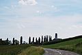
Römerswil seen from the northeast
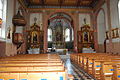
Interior of the church

Parish hall

Village shop

school
_181.JPG)
_193.JPG)
_217.JPG)
_189.JPG)
_231.JPG)
Web links
- Official website of the municipality of Römerswil
- Community profile of the cantonal statistical office (PDF, 101 kB)
- Waltraud Hörsch: Herlisberg. In: Historical Lexicon of Switzerland .
- Waltraud Hörsch: Römerswil. In: Historical Lexicon of Switzerland .
Individual evidence
- ↑ Permanent and non-permanent resident population by year, canton, district, municipality, population type and gender (permanent resident population). In: bfs. admin.ch . Federal Statistical Office (FSO), August 31, 2019, accessed on December 22, 2019 .
- ↑ Permanent resident population according to nationality category, gender and municipality ( memento of the original from January 1, 2015 in the Internet Archive ) Info: The archive link was inserted automatically and has not yet been checked. Please check the original and archive link according to the instructions and then remove this notice. (Permanent resident population)
- ↑ Balance of the permanent resident population according to demographic components, institutional structure, nationality and gender (Federal Statistical Office, STAT-TAB)
- ↑ LUSTAT: Community profile Römerswil ( Memento of the original from May 8, 2016 in the Internet Archive ) Info: The archive link has been inserted automatically and has not yet been checked. Please check the original and archive link according to the instructions and then remove this notice.
- ↑ LUSTAT: Community profile Römerswil ( Memento of the original from May 8, 2016 in the Internet Archive ) Info: The archive link has been inserted automatically and has not yet been checked. Please check the original and archive link according to the instructions and then remove this notice.
- ↑ National Council elections 2015: strength of the parties and voter turnout by municipality. In: Results of the National Council elections 2015. Federal Statistical Office, 2016, accessed on June 1, 2016 .
Aesch | Altwis | Ballwil | Emmen | Ermensee | Eschenbach | Hitzkirch | Hochdorf | Hohenrain | Inwil | Rain | Römerswil | Rothenburg | Schongau
Former communities: Gelfingen | Hemicon | Herlisberg | Lieli | Mosen | Müswangen | Retschwil | Richensee | Sulz
Canton of Lucerne | Constituencies of the Canton of Lucerne | Municipalities of the Canton of Lucerne