
Inwil
| Inwil | |
|---|---|
 |
|
| State : |
|
| Canton : |
|
| Constituency : | Hochdorf |
| BFS no. : | 1033 |
| Postal code : | 6034 |
| Coordinates : | 669 164 / 219425 |
| Height : | 424 m above sea level M. |
| Height range : | 399–551 m above sea level M. |
| Area : | 10.32 km² |
| Residents: | 2620 (December 31, 2018) |
| Population density : | 254 inhabitants per km² |
|
Proportion of foreigners : (residents without citizenship ) |
10.7% (December 31, 2,015) |
| Website: | www.inwil.ch |
| Location of the municipality | |
  |
|
Inwil (in the Swiss German local dialect Eibu [ ˈeibʊ ]) is a political municipality in the constituency of Hochdorf in the Swiss canton of Lucerne .
geography
The community extends from the foothills of the Lindenberg, the Inwilerberg 551 m above sea level. M. to the north bank of the Reuss and lies between Lucerne and Zug.
The village of Inwil and the hamlet of Oberhofen 420 m above sea level. M. have now grown together. The district of Pfaffwil 411 m above sea level. M. is 2.7 km northeast of the village. The hamlet of Ausserschachen is 415 m above sea level to the south of the village . M. and in a southeast direction at a distance of 1.5 km on the Reuss is the former monastery of St. Kathrinen .
The municipality covers an area of 1032 hectares. 70.6% of this is used for agriculture; 16.2% is covered by forest and wood and 11.6% is settlement area. The highest point of the municipality is at 551 m above sea level. M. on the Inwilerberg, the deepest on the border with Gisikon at 406 m above sea level. M.
The neighboring communities of Ballwil , Buchrain , Eschenbach , Gisikon , Honau and Root are located in the canton of Lucerne . To the east, Inwil borders the canton of Aargau , more precisely the communities Dietwil and Sins .
population
| Population development | |
|---|---|
| year | Residents |
| 1798 | 670 |
| 1837 | 1,014 |
| 1888 | 733 |
| 1941 | 1,028 |
| 1950 | 1,040 |
| 1960 | 1,165 |
| 1970 | 1,242 |
| 1980 | 1,375 |
| 1990 | 1,466 |
| 2000 | 1,783 |
| 2008 | 2,140 |
| 2010 | 2,094 |
The population grew rapidly until 1837. As a result of emigration, it then fell by 27.7% in the few decades up to 1888, after which it recovered and reached the level of 1837 again in 1941. After stagnating in the 1940s, steady growth began and continues to this day.
languages
The population speaks a highly Alemannic dialect. In the 2000 census, 95.63% gave German, 1.51% Serbo-Croatian and 1.18% Portuguese as their main / everyday language.
Religions - denominations
The previously purely Roman Catholic population today offers the following picture: 83.29% Roman Catholic, 7.35% Evangelical Reformed and 1.74% Orthodox Christians. In addition, there were 4.66% without religious affiliation and 0.67% Muslim. The Orthodox are Serbs and Montenegrins by origin, the Muslims Albanians and Bosniaks (as of 2000).
Origin - nationality
At the end of 2014, 2,179 of the 2,429 inhabitants were Swiss and 250 (= 10.3%) were foreigners. The population consisted of 89.7% Swiss citizens. At the end of 2014, the foreign residents came from Germany (27.6%), Serbia including Kosovo (17.2%), Italy (8.8%), Portugal (3.2%), Spain (3.2%) and the Turkey (2.4%). 28.0% came from the rest of Europe and 9.6% were of non-European origin.
history
The earliest mentioned district of today's municipality Inwil is the hamlet of Utigen (north of the village) in 1045 as a place of the Beromünster Abbey subject to interest . Today's village of Inwil is first mentioned by name in 1145 as Ingenwilare in a confirmation of ownership to the Allerheiligen monastery in Schaffhausen .


However, the main settlement in the municipality was Alt-Eschenbach , ancestral seat of the Barons of Eschenbach . The castle was built on a flat hill on the Reuss. Around 1300 a small town was built around it. In 1285 a women's monastery was even built there (the St. Katharinen chapel is a remnant), today's Eschenbach monastery , which was moved to Obereschenbach in 1309. Because Walter IV von Eschenbach, who grew up in poverty through the fault of the Habsburgs, was involved in the regicide of Albrecht von Habsburg on May 1, 1308, he was placed under imperial ban and the castle and town were destroyed.
Another castle was built in Iberg ruins (today a homestead 3 km northeast of the village), which gave its name to a knight family of the Lords of Iberg . Since the knights were partisans of the Habsburgs, the castle was destroyed by the confederates in 1386.
During the great Swiss Peasants' War , parts of the peasant army holed up on the Reuss. Because of the importance of the river crossing, the bridgehead played an important role several times ( Villmerger Wars , Sonderbund War ).
The community came under the rule of the Habsburgs as early as the 13th century. Until the murder of the emperor, the people of Eschenbach exercised the administration. Then it came under the administration of the barons of Rothenburg . After the defeat of the Habsburgs in the Battle of Sempach in 1386, the city of Lucerne took over the role of the Habsburgs. Inwil belonged to the Landvogtei Rothenburg until 1798 . It was then part of the Hochdorf district until 1803 - this then went under in the then newly created Hochdorf office , to which the community still belongs to this day.
politics
Municipal council
The Inwil municipal council consists of five members and is set up as follows:
- Josef Mattmann: Mayor
- Gregor Jung: Finances
- Fabian Peter: Building, planning, developing
- Heidi Rohrer: Social
- Brigitta Jozsa-Jans: Education
Cantonal elections
In the 2015 Cantonal Council elections for the Canton of Lucerne, the proportion of voters in Inwil was: FDP 38.1%, CVP 26.6%, SVP 24.2%, SP 5.3%, GPS 2.7%, glp 2.5%.
National Council elections
In the 2015 Swiss parliamentary elections, the share of the vote in Inwil was: SVP 34.3%, CVP 26.8%, FDP 20.8%, SP 6.7%, glp 5.6%, GPS 3.5%, BDP 1, 7%.
traffic
The municipality is connected to the public transport network by bus line 22 of the Lucerne public transport company (Lucerne – Inwil / Perlen). The nearest train stops are Eschenbach LU and Waldibrücke LU on the Lucerne – Lenzburg line and Gisikon-Root on the Lucerne – Zurich line . There is also a bus between Hochdorf and Rotkreuz with a stop in Inwil and a bus to Emmen.
The place is on the Gisikon – Eschenbach LU road. The motorway connections Inwil – Gisikon on the A14 in 4 km and Emmen-Süd on the A2 in 8 km provide a good connection to the motorway network. Another motorway connection is in Buchrain (neighboring municipality).
Attractions
photos

Inwil Church

Interior of the church

Entrance to Inwil
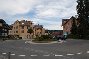
Roundabout in the village center
_409.JPG)
_423.JPG)
_404.JPG)
_415.JPG)
Web links
- Official website of the municipality of Inwil
- Community profile of the cantonal statistical office (PDF, 109 kB)
- Waltraud Hörsch: Inwil (LU). In: Historical Lexicon of Switzerland .
Individual evidence
- ↑ Permanent and non-permanent resident population by year, canton, district, municipality, population type and gender (permanent resident population). In: bfs. admin.ch . Federal Statistical Office (FSO), August 31, 2019, accessed on December 22, 2019 .
- ↑ Permanent resident population according to nationality category, gender and municipality ( memento of the original from January 1, 2015 in the Internet Archive ) Info: The archive link was inserted automatically and has not yet been checked. Please check the original and archive link according to the instructions and then remove this notice. (Permanent resident population)
- ↑ Basic material of the language atlas of German-speaking Switzerland ; the specification [ ˈæibʊ ] in the lexicon of Swiss municipality names is incorrect.
- ↑ Balance of the permanent resident population according to demographic components, institutional structure, nationality and gender (Federal Statistical Office, STAT-TAB)
- ↑ LUSTAT: Community profile Inwil ( Memento of the original from May 8, 2016 in the Internet Archive ) Info: The archive link was inserted automatically and has not yet been checked. Please check the original and archive link according to the instructions and then remove this notice.
- ^ Seetal, castles, palaces, mounds of earth: Iberg, Inwil , seetal-plus.ch
- ↑ LUSTAT: Community profile Inwil ( Memento of the original from May 8, 2016 in the Internet Archive ) Info: The archive link was inserted automatically and has not yet been checked. Please check the original and archive link according to the instructions and then remove this notice.
- ↑ National Council elections 2015: strength of the parties and voter turnout by municipality. In: Results of the National Council elections 2015. Federal Statistical Office, 2016, accessed on June 1, 2016 .
Aesch | Altwis | Ballwil | Emmen | Ermensee | Eschenbach | Hitzkirch | Hochdorf | Hohenrain | Inwil | Rain | Römerswil | Rothenburg | Schongau
Former communities: Gelfingen | Hemicon | Herlisberg | Lieli | Mosen | Müswangen | Retschwil | Richensee | Sulz
Canton of Lucerne | Constituencies of the Canton of Lucerne | Municipalities of the Canton of Lucerne