Highway 14 (Switzerland)
| Autobahn 14 in Switzerland | |

|
|
| map | |
| Basic data | |
| Operator: | Federal Roads Office |
| Start of the street: |
Emmenbrücke ( 47 ° 4 ′ N , 8 ° 18 ′ E ) |
| End of the road: |
Sihlbrugg ( 47 ° 13 ′ N , 8 ° 33 ′ E ) |
| Overall length: | approx. 29 km |
|
Canton : |
|
| Development condition: | to Sihlbrugg completely |
|
Course of the road
|
|
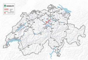
The Swiss motorway A14 in central Switzerland is a link between the motorway A2 and Sihlbrugg . It runs together with the A4 between the Rütihof and Blegi junction . The A14 is part of the national road 14, which connects Lucerne in central Switzerland with Wädenswil on Lake Zurich .
The motorway begins at the Rotsee junction with km −0.100 and runs mostly along the Reuss , which it crosses twice. The second time you cross the Reuss on the Reussbrücke, the second highest bridge in the canton of Zug , before it joins the A4 at the Rütihof junction at about 15 km. There is an automatic cruise control system almost throughout this section. During peak hours the speed limit is often 80 km / h. The second section between Blegi and Sihlbrugg is around nine kilometers long. This was a cantonal road until 2020 and was considered the A4a motorway feeder before it was added to the national road network.
