Hauptstrasse 16
| Hauptstrasse 16 in Switzerland | |||||||||||||||||||||||||||||||||||||||||||||||||||||||||||||||||||||||||||||||||||||||||||||||||||||||||||||||||||||||||||||||||||||||||||||||||||||||||||||||||||||||||||||||||||||||||||||||||||||||||||||||||||||||||||||||||||||||||||||||||||||||||||||||||||||||||||||||||||||||||||||||||||||||||||||||||||

|
|||||||||||||||||||||||||||||||||||||||||||||||||||||||||||||||||||||||||||||||||||||||||||||||||||||||||||||||||||||||||||||||||||||||||||||||||||||||||||||||||||||||||||||||||||||||||||||||||||||||||||||||||||||||||||||||||||||||||||||||||||||||||||||||||||||||||||||||||||||||||||||||||||||||||||||||||||
| map | |||||||||||||||||||||||||||||||||||||||||||||||||||||||||||||||||||||||||||||||||||||||||||||||||||||||||||||||||||||||||||||||||||||||||||||||||||||||||||||||||||||||||||||||||||||||||||||||||||||||||||||||||||||||||||||||||||||||||||||||||||||||||||||||||||||||||||||||||||||||||||||||||||||||||||||||||||
| Basic data | |||||||||||||||||||||||||||||||||||||||||||||||||||||||||||||||||||||||||||||||||||||||||||||||||||||||||||||||||||||||||||||||||||||||||||||||||||||||||||||||||||||||||||||||||||||||||||||||||||||||||||||||||||||||||||||||||||||||||||||||||||||||||||||||||||||||||||||||||||||||||||||||||||||||||||||||||||
| Operator: | Canton Thurgau: state border D / CH - canton border TG / SG Canton St. Gallen: |
||||||||||||||||||||||||||||||||||||||||||||||||||||||||||||||||||||||||||||||||||||||||||||||||||||||||||||||||||||||||||||||||||||||||||||||||||||||||||||||||||||||||||||||||||||||||||||||||||||||||||||||||||||||||||||||||||||||||||||||||||||||||||||||||||||||||||||||||||||||||||||||||||||||||||||||||||
| Start of the street: |
Constance ( 47 ° 40 ′ N , 9 ° 10 ′ E ) |
||||||||||||||||||||||||||||||||||||||||||||||||||||||||||||||||||||||||||||||||||||||||||||||||||||||||||||||||||||||||||||||||||||||||||||||||||||||||||||||||||||||||||||||||||||||||||||||||||||||||||||||||||||||||||||||||||||||||||||||||||||||||||||||||||||||||||||||||||||||||||||||||||||||||||||||||||
| End of the road: |
Schaanwald ( 47 ° 13 ′ N , 9 ° 34 ′ E ) |
||||||||||||||||||||||||||||||||||||||||||||||||||||||||||||||||||||||||||||||||||||||||||||||||||||||||||||||||||||||||||||||||||||||||||||||||||||||||||||||||||||||||||||||||||||||||||||||||||||||||||||||||||||||||||||||||||||||||||||||||||||||||||||||||||||||||||||||||||||||||||||||||||||||||||||||||||
| Overall length: | approx. 103 km Switzerland: approx. 94 km Liechtenstein: approx. 9 km |
||||||||||||||||||||||||||||||||||||||||||||||||||||||||||||||||||||||||||||||||||||||||||||||||||||||||||||||||||||||||||||||||||||||||||||||||||||||||||||||||||||||||||||||||||||||||||||||||||||||||||||||||||||||||||||||||||||||||||||||||||||||||||||||||||||||||||||||||||||||||||||||||||||||||||||||||||
|
Canton : |
|||||||||||||||||||||||||||||||||||||||||||||||||||||||||||||||||||||||||||||||||||||||||||||||||||||||||||||||||||||||||||||||||||||||||||||||||||||||||||||||||||||||||||||||||||||||||||||||||||||||||||||||||||||||||||||||||||||||||||||||||||||||||||||||||||||||||||||||||||||||||||||||||||||||||||||||||||
| Development condition: | double lane, non-separated carriageway |
||||||||||||||||||||||||||||||||||||||||||||||||||||||||||||||||||||||||||||||||||||||||||||||||||||||||||||||||||||||||||||||||||||||||||||||||||||||||||||||||||||||||||||||||||||||||||||||||||||||||||||||||||||||||||||||||||||||||||||||||||||||||||||||||||||||||||||||||||||||||||||||||||||||||||||||||||
|
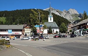
Wildhauserpass (highest point on Hauptstrasse 16) |
|||||||||||||||||||||||||||||||||||||||||||||||||||||||||||||||||||||||||||||||||||||||||||||||||||||||||||||||||||||||||||||||||||||||||||||||||||||||||||||||||||||||||||||||||||||||||||||||||||||||||||||||||||||||||||||||||||||||||||||||||||||||||||||||||||||||||||||||||||||||||||||||||||||||||||||||||||
|
Course of the road
|
|||||||||||||||||||||||||||||||||||||||||||||||||||||||||||||||||||||||||||||||||||||||||||||||||||||||||||||||||||||||||||||||||||||||||||||||||||||||||||||||||||||||||||||||||||||||||||||||||||||||||||||||||||||||||||||||||||||||||||||||||||||||||||||||||||||||||||||||||||||||||||||||||||||||||||||||||||
The main road 16 is a main road in Switzerland and the Principality of Liechtenstein .
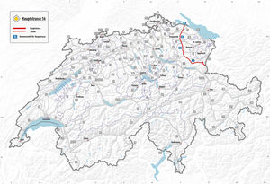
It begins near Konstanz / Kreuzlingen and runs through the Toggenburg , the Rhine Valley and the Principality of Liechtenstein and ends at the border with Austria near Feldkirch .
course
The road begins at Tägermoos in Tägerwilen on the border with Germany at Gottlieber Zoll, connected by a small connecting road with federal highway 33 . From there the road runs over the Seerücken into the Thur Valley near Märstetten . The road then runs through the Fürstenland to Wil SG .
From there the main road runs along the Thur to Wildhaus . At Bazenheid the main road is interrupted and replaced by a bypass road, which is classified as a car road , and the main road is signaled accordingly. At Lichtensteig and Ebnat-Kappel there is a bypass road as a car road, which relieves the main road that runs through these places.
From 1090 m above sea level From the Wildhauserpass , the road leads down into the Rhine Valley to Gams and Buchs . The road crosses the Rhine between Buchs and Schaan and reaches the Principality of Liechtenstein. There the road runs via Schaan and Schaanwald to the border with Austria near Feldkirch, where it continues as the Liechtensteiner Straße .
The total length of this mostly non-directional thoroughfare is around 103 kilometers, of which around 9 kilometers are in the principality.
history
Liechtenstein
The Deutsche Strasse from Feldkirch via Schaan to Chur was completed in 1786. In Austria today it is known as Liechtensteiner Strasse .
St. Gallen
Beda Angehrn , Abbot of the St. Gallen Monastery , promoted road construction in his territory. The Toggenburgerstrasse was built between Wil and Wattwil between 1774 and 1787 . This road crossed the county of Toggenburg and connected it with the city of Wil in the Fürstenland . The Toggenburgerstrasse was entirely on the territory of the Abbey of what simplified trading in peacetime and military transports in wartime.
The state road from Gams to Liechtenstein was not completed until 1836, when the swamps of the Alpine Rhine Valley were no longer flooded as a result of the Rhine correction .
On the St. Gallen section, the main road, with the exception of the sections for which a bypass exists, is canton road 13 Wil – Haag. Since 1963, local bypasses have been opened along the main road in the canton of St. Gallen:
Thurgau
Until 1803, Thurgau was a common rule , i.e. a subject area with no rights and administered jointly by the federal city-states. Since 1803, the newly founded canton of Thurgau has been able to dispose of its own tax revenue and decided on an extensive road construction program. In 1806 the government decided to build a road between Märstetten and Wil. In 1811 the decision was made to build a road between Wäldi and Märstetten.
Project planning
The canton council has decided to bypass the villages of Bütschwil , Dietfurt and Wattwil . The Bütschwil bypass was under construction in 2017, and it should be opened to traffic in 2020. The Wattwil bypass was tackled in 2018 and should be ready by 2022 or 2023. After these bypasses have been expanded, the autostrasse will lead from Wil-Süd to Ebnat-Kappel, interrupted by a section near Lütisburg between Bazenheid and Bütschwil and all town centers between Wil and Wildhaus with the exception of Nesslau-Neu St. Johann and Stein SG will be bypassed.
Individual evidence
- ↑ Canton Bulletin St. Gallen
- ↑ St. Galler Tagblatt: Core measures of the agglo program . In: St.Galler Tagblatt . March 12, 2016 ( tagblatt.ch [accessed November 7, 2017]).
- ↑ http://www.tagblatt.ch/ostschweiz/ Werdenberg/Kantonsstrasse-bis-Oktober-nur-noch-einspurig-befahrbar; art415141,4185413
- ↑ Canton of Thurgau
- ↑ Martin Knoepfel: Provisional road for the construction of the tunnel . In: St.Galler Tagblatt . September 7, 2017 ( tagblatt.ch [accessed November 7, 2017]).
- ↑ Start preparatory work for the 2nd stage of the Wattwil bypass. Canton of St.Gallen, accessed on November 7, 2017 .


