
Amlikon
| Amlikon | ||
|---|---|---|
 |
||
| State : |
|
|
| Canton : |
|
|
| District : | Weinfelden | |
| Political community : | Amlikon-Bissegg | |
| Postal code : | 8514 | |
| former BFS no. : | 4881 | |
| Coordinates : | 721 957 / 270236 | |
| Height : | 422 m above sea level M. | |
| Area : | 2.79 km² (local parish ) 14.47 km² (municipality) |
|
| Residents: | 534 (December 31, 2018) | |
| Population density : | 191 inhabitants per km² | |
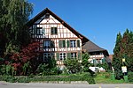
 Picturesque half-timbered houses in Amlikon |
||
| map | ||
|
||

Amlikon is a former local and municipal municipality and part of the municipality of Amlikon-Bissegg in the Weinfelden district of the canton of Thurgau in Switzerland . The municipality of Amlikon comprised the municipalities of Amlikon, Bissegg , Griesenberg and Strohwilen . On January 1, 1995 , the five municipalities merged to form the political municipality of Amlikon-Bissegg.
geography
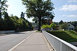
The bridge village Amlikon on the Konstanz - Wil SG road on the left bank of the Thur extends over both banks of the Thur .
history

The place is first mentioned in 1282 as Amlikon . In the High Middle Ages, Amlikon belonged to the territory of the Barons of Bussnang . From the middle of the 13th century until 1798 it was under the jurisdiction of Griesenberg . Amlikon has always been part of the Bussnang parish. A ferry connection across the Thur is first mentioned in the 14th century. This was replaced by a bridge in 1727. In 1821 a covered bridge was built and in 1832 the steep road leading to the village was replaced by an S-curvy village road. The bridge from 1821 was destroyed by a flood on June 15, 1910, whereupon an iron construction bridge was built from 1911 to 1912, which in turn was replaced by a concrete bridge in 1995.
Up until the 19th century, three-field grain cultivation and hemp cultivation were the main agricultural livelihoods. In the 19th century the majority went over to cattle and dairy farming. The first cheese factory was built in 1908. In the 19th century, Amlikon had an oil mill. Vines are still cultivated today. At the beginning of the 20th century, there were several embroidery shops in the village. The permanent settlement of industry was not successful. To this end, a number of businesses have set up, z. B. in construction company since 1934. In 1990, 54% of jobs were in the second, but 19% still in the first economic sector .
| year | 1850 | 1900 | 1960 | 1970 | 1990 | 2000 | 2010 | 2018 |
|---|---|---|---|---|---|---|---|---|
| Municipal parish | 1181 | 1097 | 1033 | 990 | 963 | |||
| Local parish | 278 | 303 | 258 | 352 | ||||
| settlement | 376 | 450 | 534 | |||||
| source | ||||||||
coat of arms
Blazon : Azure, a yellow boat, pale as covered by two yellow rowing.
The ship is reminiscent of the former Thur ferry in Amlikon.

traffic
In public transport Amlikon is from the post bus line Frauenfeld - Thundorf TG - Weinfelden developed. On the southern bank of the Thur north of the village of Amlikon, the Amlikon glider airfield has been located since 1963 , which serves as the home base of the Cumulus glider group . It was created after the airfield on the Allmend near Frauenfeld was needed by the military.
Attractions
Amlikon has a village square with picturesque half-timbered buildings . The list of cultural assets in Amlikon-Bissegg includes the half-timbered houses Klösterli 1 and Klösterli 3 in Amlikon .
photos
Entrance to Amlikon at the Thur bridge

"Ox" on Schwabenweg from Konstanz to Einsiedeln
Half-timbered house Klösterli 1

Half-timbered house Klösterli 3
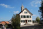
Old school house
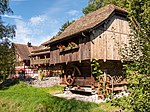
Speicher, Remise and residential building "Alte Mühle"
_004.JPG)

_013.JPG)
_015.JPG)
_029.JPG)

Web links
Individual evidence
- ↑ Swiss land use statistics. Completed on July 1, 1912. Published by the Federal Statistical Bureau. ( Memento from April 12, 2016 in the Internet Archive )
- ↑ Thurgau in figures 2019 . On the website of the Statistical Office of the Canton of Thurgau (PDF file; 1.8 MB), accessed on April 28, 2020.
- ↑ a b List of Settlements. Canton of Thurgau, edition 2019 . On the website of the Statistical Office of the Canton of Thurgau (Excel table; 0.2 MB), accessed on May 10, 2020.
- ↑ Localities and their resident population. Edition 2019 . On the website of the Statistical Office of the Canton of Thurgau (Excel table; 0.1 MB), accessed on April 28, 2020.
-
^ A b c
André Salathé: Amlikon. In: Historical Lexicon of Switzerland .
These sections are largely based on the entry in the Historical Lexicon of Switzerland (HLS), which, according to the HLS's usage information, is under the Creative Commons license - Attribution - Share under the same conditions 4.0 International (CC BY-SA 4.0). - ↑ Population development of the municipalities. Canton Thurgau, 1850–2000 and resident population of the municipalities and change from the previous year. Canton of Thurgau, 1990–2018. On the website of the Statistical Office of the Canton of Thurgau (Excel tables; 0.1 MB each), accessed on April 28, 2020.
- ↑ Locations and Settlements Directory. Canton of Thurgau, 2005 edition . On the website of the Statistical Office of the Canton of Thurgau (PDF; 1.7 MB), accessed on April 28, 2020.
- ↑ Locations and Settlements Directory. Canton of Thurgau, 2012 edition. On the website of the Statistical Office of the Canton of Thurgau (PDF; 3.4 MB), accessed on May 11, 2020.
- ↑ a b municipal coat of arms . On the website of the State Archives of the Canton of Thurgau, accessed on December 8, 2019
← Previous location: Märstetten | Amlikon | Next town: Affeltrangen →
Affeltrangen | Amlikon-Bissegg | Mountain | Birwinken | Bischofszell | Bürglen | Bussnang | Alder | Hauptwil-Gottshaus | Hohentannen | Kradolf-Schönenberg | Märstetten | Schönholzerswilen | Sulgen | Weinfelden | Wigoltingen | Wuppenau | Zihlschlacht-Sitterdorf
Former municipalities: Amlikon | Andhausen | Andwil | Bissegg | Bleiken | Bonau | Book at Märwil | Buchackern | Buhwil | Donzhausen | Engishofen | Engwang | Ennetaach | Friltschen | Götighofen | House of God | Graltshausen | Griesenberg | Guntershausen near Birwinken | Heaps | Happerswil book | Hauptwil | Holy Cross | Heldswil | Hessenreuti | Pants jerk | Illhart | Istighofen | Klarsreuti | Kradolf | Kümmertshausen | Lamperswil | Lanterswil | Leimbach | People mark | Märwil | Mattwil | Mettlen | Neukirch an der Thur | Oberbussnang | Opfershofen | Oppikon | Ottoberg | Reuti | Riedt | Rothenhausen | Schönenberg | Swiss wood | Sitterdorf | Strohwilen | Toos | Weerswilen | Zezikon | Zihlschlacht
Canton of Thurgau |
Districts of the Canton of Thurgau |
Municipalities of the Canton of Thurgau