Lippoldswilen
| Lippoldswilen | ||
|---|---|---|
| State : |
|
|
| Canton : |
|
|
| District : | Kreuzlingen | |
| Political community : | Kemmental | |
| Postal code : | 8566 | |
| former BFS no. : | 4635 | |
| Coordinates : | 725 855 / 274 845 | |
| Height : | 508 m above sea level M. | |
| Area : | 1.88 km² | |
| Residents: | 170 (December 31, 2018) | |
| Population density : | 90 inhabitants per km² | |
|
Lippoldswilen |
||
| map | ||
|
|
||
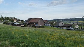
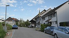
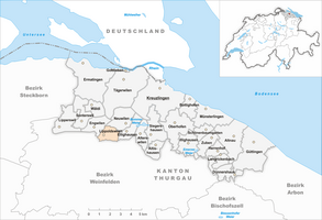
Lippoldswilen is a former municipality and a village in the municipality of Kemmental in the Kreuzlingen district of the canton of Thurgau in Switzerland . The village, which belonged to the municipality of Alterswilen until 1995, is located in the Kemmental off the through routes and includes Lippoldswilen, Unterstöcken and six other farms. On January 1, 1996 , the former local church merged to form the Kemmental municipality.
history
Lippoldswilen was first mentioned in 1303 as Lupoltwile . The Zapfenloh or Scheidbach castle site is not mentioned in a document.
![]()
As a fiefdom of the Bishop of Constance , the bailiwick of the village came from Ulrich von Klingenberg to the Constance residents Johannes and Ulrich Pfefferhard in 1308 . After the conquest of Thurgau by the Confederates in 1460, Lippoldswilen, as a so-called High Court, was subject to the high as well as the lower jurisdiction of the federal bailiff in Frauenfeld . Unteröcken and Krachenburg belonged to the Raiti court .
Lippoldswilen was always parish in accordance with Alterswilen. After the Reformation in 1529, the few Catholics went to church in Bernrain , and since 1831 they have belonged to the Catholic parish of Emmishofen .
From 1847 to 1852 Lippoldswilen was under state administration. The Lippoldswiler school dispute in 1862/63, a trial of strength between the cantonal government with Philipp Gottlieb Labhardt and the education council presided over by Eduard Häberlin , heralded the democratic movement in the canton of Thurgau.
In the 19th century, Lippoldswilen went from growing grain in three tents to cattle and dairy farming. In 1934 a cheese dairy was opened. Numerous hand stickers lived in Lippoldswilen from 1870 to 1910. Between 1967 and 1987 the goods were amalgamated.
population
| year | 1850 | 1900 | 1950 | 1990 | 2000 | 2010 | 2018 |
| Local parish | 153 | 154 | 138 | 97 | |||
| Locality | 48 | 86 | 170 | ||||
| source | |||||||
Of the total of 170 inhabitants in Lippoldswilen in 2018, 29 or 17.1% were foreign nationals. 97 (57.1%) were Protestant Reformed and 33 (19.4%) were Roman Catholic.
literature
- André Salathé: Lippoldswilen. In: Historical Lexicon of Switzerland .
This article is largely based on the entry in the Historisches Lexikon der Schweiz (HLS), which, according to the HLS's usage information, is licensed under the Creative Commons - Attribution - Distribution under the same conditions 4.0 International (CC BY-SA 4.0) license .
Web links
Individual evidence
- ↑ Swiss land use statistics. Completed on July 1, 1912. Published by the Federal Statistical Bureau. ( Memento from April 12, 2016 in the Internet Archive )
- ↑ a b c d Localities and their resident population. Edition 2019 . On the website of the Statistical Office of the Canton of Thurgau (Excel table; 0.1 MB), accessed on April 28, 2020.
- ↑ Locations and Settlements Directory. Canton of Thurgau, 2005 edition . On the website of the Statistical Office of the Canton of Thurgau (PDF; 1.7 MB), accessed on April 28, 2020.
- ↑ Locations and Settlements Directory. Canton of Thurgau, 2012 edition. On the website of the Statistical Office of the Canton of Thurgau (PDF; 3.4 MB), accessed on May 11, 2020.
Remarks
- ↑ with outside courtyards
← Previous location: Ellighausen | Lippoldswilen | Next town: Märstetten →


